


The Holy Land and surrounding regions in the Levant contain some of the most sacred and enigmatic places in the world. It has been determined that some of these places contain structures that are aligned to what could have been previous locations of the North Pole over the past 100,000 years or more. This article reveals that these places are not exceptional in this regard but are among numerous other sites in this part of the world that appear to be aligned to former poles and thus could be much older than mainstream archaeological theories maintain.
Click here to read the full paper.
I put to Emir Hangar the question, who built Baalbeck? His answer was – “There have been three builders; the first was Sanoud, the second was (I have forgotten the name), and then came the Deluge; after that it was repaired by Solomon.”
David Urquhardt, The Lebanon: A History and a Diary, 1860
Baalbek
This site on which a succession of temples and other structures have been built contains, at its base, the largest megalithic blocks in the world. In all, seven stages of construction are evident. The plan of the original structure is a square enclosure (Urquhardt 1860):
A small portion only of this has been completed in the old work, namely, the angle of the north-west, and the adjoining walls. It is there that may be seen the 70 feet stones built into the walls in tiers, and hoisted up 20 feet, and placed on several layers of smaller stones.
Two unknown periods of construction are above this:
The remainder of the space is filled up with piles of stones, entirely of another order. Through these, two vaults are open, leading to the inference, that it is all vaulted below: these again may be divided into two orders; one [second period] may be called Cyclopic, the stones being irregular, the sides varying from 5 to 6 and 7 feet. The other [third period] is more systematic, and combines some thing of the Etruscan and the Egyptian, an arch being traceable in the one style, and a portal in the other.

Above these ancient foundations are four historical periods of construction. According to Urquhardt
In one of the vaults, about eight feet from the ground, a stone has, by some accident, been removed, and my attention having been called to it by traces of fodder, I had myself lifted up, and got into a crypt beyond… I could not doubt that I stood in a Phoenician Temple, perhaps the only one that still exists.
Next are the restored Greek and Roman ruins, an enormous peristyle known as the Temple of Jupiter.
Robinson (1852) describes Baalbek’s megalithic foundation in greater detail:
Not less wonderful than the other parts of the great temple are the immense external substructions, by which the walls supporting the peristyle are enclosed and covered; if indeed that term can be properly applied to huge masses of masonry, on which nothing rests. This external substruction wall is found on the north side and west end of the peristyle; and exists also probably on the south side beneath the mounds of rubbish…
The most imposing of these substructions is the western wall, as viewed from the outside. It rises to the level of the bottom of the columns, some fifty feet above the surface of the ground; and in it is seen the layer of three immense stones celebrated by all travelers. Of these stones, the length of one is sixty-four feet; of another, sixty-three feet eight inches; and of the third, sixty-three feet; in all one hundred ninety feet eight inches. Their height is about thirteen feet; and the thickness apparently the same, or perhaps greater. They are laid about twenty feet above the ground; and below them are seven others of like thickness, and extending somewhat beyond the upper ones at each end.
In a quarry less than a kilometer from the temple lies an enormous stone block approximately 20 x 4 x 4 meters in size and weighing an estimated one thousand tons. It is likely the quarry dates back to the time of the original construction:
On the north, the substruction wall is only about twenty feet in height, and was never completed. It also is built up of cyclopean work; immense stones laid as brought from the quarry, but never dressed smooth. Here are nine stones, measuring on an average thirty-one feet in length, nine feet seven inches in breadth, and thirteen feet in depth. In speaking of the huge block still lying in the quarry, I have said that there would seem to be no place for it in the plan of the present structures. Still, it may not be impossible, that the said block was intended to be placed upon this very wall, in a line with the similar course at the west end; but for some reason the work was abandoned, and the wall left in its present unfinished state.
Interesting, like the uncompleted temple at Ollantaytambo containing the Wall of the Six Monoliths, the megalithic foundations at Baalbek were never completed. To Urquhardt, its great antiquity is clear:
The builders of Baalbeck must have been a people who had attained to the highest pinnacle of power and science; and this region must have been the centre of their dominion. We are perfectly acquainted with the nations who have flourished here or around, and their works; they are the Assyrians, Chaldeans, Medes, Persians, Egyptians, Canaanites, and Jews. These complete the catalogue of ancient empires, and this work is none of theirs.

The orientation of the original square enclosure is rotated approximately 12° west of north. This direction, which has no known astronomical or cultural significance, points directly toward the Greenland pole. By virtue to its alignment to this former pole the earliest foundations at Baalbek could be 85,000 to 130,000 years old.
Jerusalem
No less remarkable than Baalbek are the megalithic foundations in Jerusalem. The Temple Mount is a flat trapezoidal plaza surrounded by retaining walls built during the reign of Herod. The northern wall, together with the northern section of the western wall, is hidden behind residential buildings. The eastern wall is 1530 feet long and oriented approximately 7.5° west of north. The western wall, which includes the Wailing Wall, is about 1560 feet long and oriented 11.5° west of north. The southern wall, a little over 900 feet long, is laid out at a right angle to the western wall. Robinson (1852) observes:
A comparison of the antique portions of the southern wall with the masonry of the Jews’ wailing place, and that at the southwest and southeast corners, left upon our minds the strong impression, that instead of this portion of the substructions being of later date than those further north, these remains of the southern wall and southeast corner present decided evidence of higher antiquity, than almost any other portions.

The largest stone block is in a section of the western wall foundation that is now below ground. Its estimated weight is 200-300 tons. According to Robinson “it might certainly be conceded that Herod may at least have rebuilt these vaults and substructions upon more ancient foundations. In this way, if necessary, most of the present appearances might doubtless be satisfactorily accounted for.”
The cardinal orientation of the site, defined by its western and southern walls to the Greenland pole, suggests the original foundations that defined the plan of Temple Mount, such as those at Baalbek, could be 85,000 to 130,000 years old. Like the Romans, nearly a thousand years later, perhaps Solomon built his temple over an even more ancient foundations that had already been in existence for many tens of thousands of years.

Other Sites Aligned to the Greenland Pole
Of all the former poles, almost as many sites are aligned to the Greenland pole alone than to the current North Pole. A site known as Ain Dara in northern Syria noted for its similarities to King Solomon’s Temple is aligned to the summer solstice sunrise/winter solstice sunset relative to the Greenland pole. Several Roman temples in Niha, Lebanon are aligned in the direction of the Greenland pole, which again raises the question as to the extent to which Roman and other previous civilizations built over earlier sites preserving their relation to former poles.


The Dead Cities
There are more than 700 ruins in northwest Syria that are believed to have been ancient settlements along long-abandoned trade routes dating back to the Byzantine Empire and earlier times. Ten of these locations have been found to contain structures aligned to former poles.


Petra
The rock-hewn city ancient city of Petra in southern Jordan is thought to have been built by the Nabateans, a nomadic people, in the fourth century BCE. Independent researcher Brien Forrester argues that the Nabateans did not build Petra but co-opted and embellished what were already ancient structures.
Recent discoveries made during an excavation at the site of the Temple of the Winged Lions (Corbett and Ronza 2014) support Forrester’s hypothesis. A goal of the excavation was to attempt to reach the level of the natural sandstone bedrock over which the temple was built:
Most perplexing was the discovery that the temple appears to have been built without proper foundations, with the bottom courses of its west wall laid down directly on a thick layer of compacted soil and rubble. What is more, there are indications that the temple was built atop earlier structures, evidenced most clearly by a fragmentary stone pavement that was laid down before the west wall of the temple was built.
Following up with geophysical survey methods they found “clearly defined, higher resistivity anomalies to a depth of 2 m below the surface, suggesting the presence of a lower layer of previously unknown structures, walls, and pavements associated with the temple. Particularly intriguing and worthy of further investigation are several chamber-like voids identified beneath the temple’s inner sanctuary.
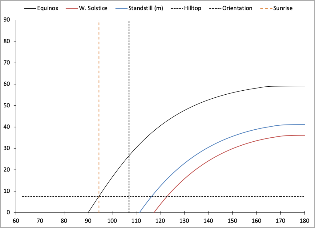
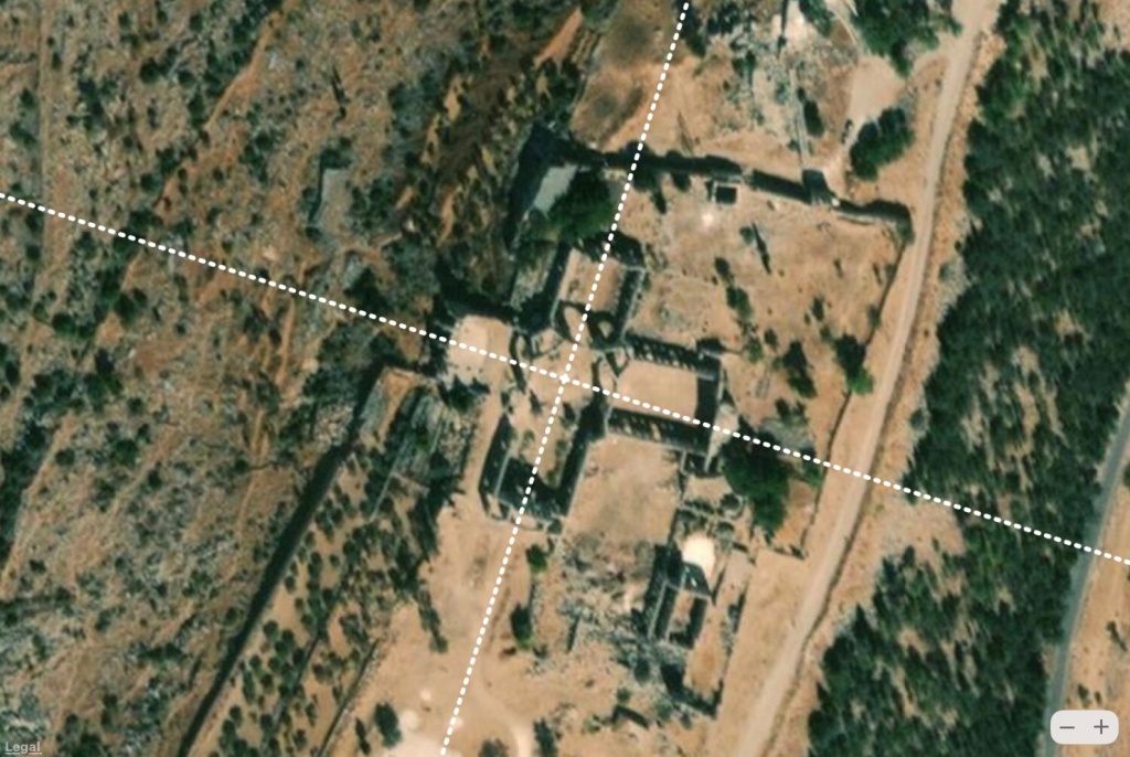
The Temple of the Winged Lions, along with a temple to the south known as Qasr el-Bint, and the surrounding landscape are all oriented in the same direction. Due to the presence of a hill to the east, if the sites were designed to face sunrise on the equinox, they would have to be rotated clockwise by a specific amount, about 4.5° as calculated graphically (see above figure). Plotting the paths of the sun on the equinox and winter solstice and the path of moon during a minor lunar standstill shows that these structures do not line up to the sun or the moon. The orientation of these sites, approximately 17° south of east, is in line with the Bering Sea pole suggesting the original foundations could have been established more than 130,000 years ago.


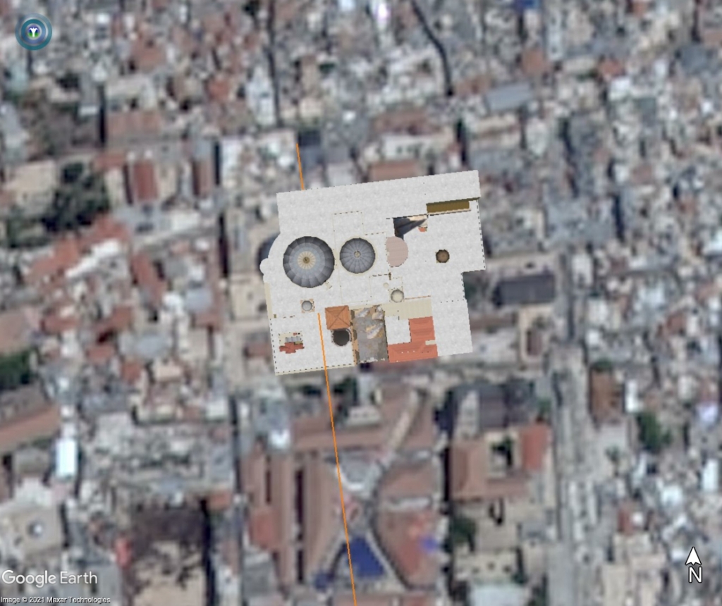
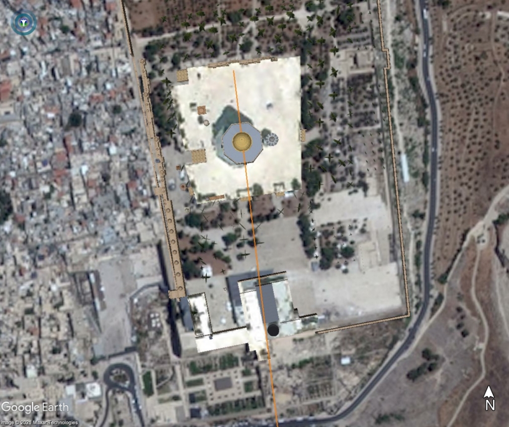
In the hills to the south, using satellite imagery to cue higher resolution UAV surveys, Parcak and Tuttle (2016) discovered a flat plaza approximately 56×49 meters in size with remains of the foundation stones of an old building, paving stones, and a column drum. The site does not appear to be aligned astronomically but is oriented in the same direction as The Great Temple east of the Qasr el-Bint. This direction is toward Baalbek about 250 miles to the north. In a similar manner, the eastern wall of Temple Mount, the Dome of the Rock, and the Church of the Holy Sepulcher in Jerusalem, and several Nabatean sites in the Levant appear to be oriented toward Petra.
Conclusion
Why do certain structures in Jerusalem appear to face Petra, and certain structures in Petra face Baalbek? Why are the ancient foundations of these sites constructed from stones weighing hundreds to thousands of tons? Why do these and dozens of other sites in this part of the Levant reference four former locations of the North Pole?
Proving what ancient people in this part of the world could or could not have done using the technology of the times is problematic. That the layout of so many sites here and in other parts of the world cannot be explained in conventional terms is a problem that has yet to be solved by the mainstream academic community. Like the legend of the Gordian Knot perhaps the solution involves “cutting the knot” by looking at the problem in a different way. We propose the simple explanation that the ancient builders aligned these sites to the sun and moon much as we have for thousands of years. But due to shifts in the location in the North Pole over the past 100,000 years the sites no longer line up in our current frame of reference, that is in relation to the current pole in the Arctic. By analyzing sites relative to former poles, the alignments of a significant number of sites are easily explained.
Our findings reveal that a series of previous (unknown) civilizations could have existed in the Levant far longer than scholars currently believe suggesting that a new interpretation of the archeological evidence may be in order.
References
Edward Robinson (1852) Later Biblical Researches in Palestine, and in the Adjacent Regions: A Journal of Travels in the Year 1852.
David Urquhardt (1860) The Lebanon (Mount Souria): A History and a Diary (Vol 2).
G. Corbett and M. Elena Ronza (2014) “What Lies Beneath—New Insights into Petra’s Temple of the Winged Lions.” ACOR 26, 4: 1-6.
Sarah Parcak and Christopher A. Tuttle (2016) “Hiding in Plain Sight: The Discovery of a New Monumental Structure at Petra, Jordan, Using WorldView-1 and WorldView-2 Satellite Imagery,” American Schools of Oriental Research. BASOR 375 (2016): 35–51.
Mark Carlotto (2019) “Computing Solar, Lunar, and Geographical Alignments of Archaeological Sites,” Available at SSRN: http://dx.doi.org/10.2139/ssrn.3484144
Mark Carlotto (2020) “A New Model to Explain the Alignment of Certain Ancient Sites,” Journal of Scientific Exploration 34(2):209-232. DOI: 10.31275/20201619.
Feature image at the top of the article, “Aerial views of the Temple Mount and parts of the Old City of Jerusalem (2007),” courtesy Andrew Shiva / Wikipedia / CC BY-SA 4.0


Mark, this is an excellent, well written, post. The photographic pole alignment visual evidence, combined with the data in the tables and prior research excerpts, is literally, and intellectually, quite illuminating! 🧐🤔 Please share this latest post with the rest of our “interested parties.” Randy 🙏🙏👍👍🔥🔥😊
Sent from Yahoo Mail for iPhone
LikeLiked by 1 person
One of my favorite ancient aliens episode was all about the large rock construction mentioned in this article. In that show a 6 1/2 ton rock that was moved in california with a specially made trailer with close to 150 wheels. A puny little rock in comparison to these ancient sites. After many years of reading and seeing things on tv, my guess is the ancients moved rocks around with vibrations. Imagine putting large tuning forks into rocks and hitting the correct vibration to levitate the rock. A lot of the sites seem to have notches in the rocks for just this purpose….
LikeLike