


Ruins of ancient shrines, temples, forts, and settlements in and around the Taklamakan Desert are generally thought to have been established no later than the third century BCE. Some of the structures at these sites excavated by M. Aurel Stein in the early 20th century were built over more ancient foundations and so could be considerably older based on their alignment to previous locations of the North Pole.
The Sand-Buried Ruins of Khotan
The Kingdom of Khotan was an ancient Iranian Saka Buddhist kingdom located on the branch of the Silk Road that ran along the southern edge of the Taklamakan Desert. The ancient capital is thought to have been founded around the third century BCE during the reign of the Indian emperor Ashoka. Stein’s interest in this region can be summarized in the following section taken from his 1904 book The Sand-Buried Ruins of Khotan:
For systematic excavations, which alone could supply this evidence, the region of Khotan appeared from the first a field of particular promise. In scattered notices of Chinese records there was much to suggest that this little kingdom, situated on the important route that led from China to the Oxus Valley and hence to India as well as to the West, had played a prominent part in developing the impulses received from India and transmitting them eastwards. The close connection with ancient Indian art seemed particularly marked in whatever of small antiques, such as pottery fragments, coins and seals, native agency had supplied from Khotan. And fortunately for our research, archaeology could here rely on the help of a very effective ally—the moving sand of the desert which preserves what it buries. Ever since human activity first created the oases of Khotan territory, their outskirts must have witnessed a continuous struggle with that most formidable of deserts, the Taklamakan; while local traditions, attested from an early date, told of settlements that had been abandoned before its advance.
More than mere stopping points along the Silk Road, Stein goes on to say:
The ruined sites explored by me have more than justified the hopes which led me to Khotan and into its desert. Scattered over an area which in a straight line extends for more than three hundred miles from west and east, and dating back to very different periods, these ruins throughout reveal to us a uniform and well-defined civilization. It is easy to recognise now that this bygone culture rested mainly on Indian foundations. But there has also come to light unmistakable evidence of other powerful influences, both from the West and from China, which helped to shape its growth and to invest it with an individual character and fascination of its own.
Using Stein’s original photos and narratives together with current high resolution satellite imagery we examine several of the sites he first uncovered. The locations of these and other sites discussed in this article are shown below.

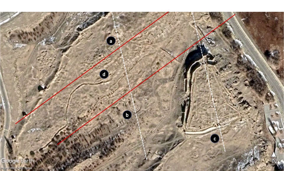
Tashkurghan
Tashkurgan is a town on the western edge of the Taklamakan Desert. The area of interest contains the ruins of a Chinese fort that Stein describes as:
A line of massive but crumbling stone walls crowns the edges of a quadrangular plateau of conglomerate cliffs, roughly one-third of a mile in length on each of its faces. A small portion of the area thus enclosed, on the east side facing the river, is occupied by the Chinese fort. Its high and carefully plastered walls of sun-dried bricks stand undoubtedly on far more ancient foundations.

Shown below, an analysis of the area reveals a circular feature (a), perhaps the remains of a Buddhist stupa, in the ruins north of the fort area. A rectilinear structure at the center rotated west of north is in the same direction of a line that passes through (a) and another circular feature (b) to the south. A line in the same direction passes through two small features along the outer wall of the fort (c). This line is in the direction of a former pole in Hudson Bay suggesting the original foundations Stein alludes to in his narrative could have been first established tens of thousands of years ago and later co-opted by the Chinese. Rectilinear patterns of ruined structures north and west of the fort (d) lie in the direction of the summer solstice sunrise/winter solstice sunset relative to the Hudson Bay pole.
2. Rawak
East of Tashkurgan in the western portion of the Taklamakan Desert is Rawak, perhaps Stein’s most remarkable find:
Here an unexpected and most gratifying discovery awaited me. Our honest old guide had spoken only of “an old house” to be seen there half-buried in the sand, but in reality the first glimpse showed a large Stupa with its enclosing quadrangle, by far the most imposing structure I had seen among the extant ruins of the Khotan region. Large dunes of coarse sand, rising over 25 feet in height, covered the quadrangle and part of the massive square base of the Stupa on the north-west and north-east faces. But towards the south the drift-sand was lower, and there great portions of the Stupa base, as well as the lines of masonry marking the quadrangular enclosure of the Stupa court, could be readily made out.
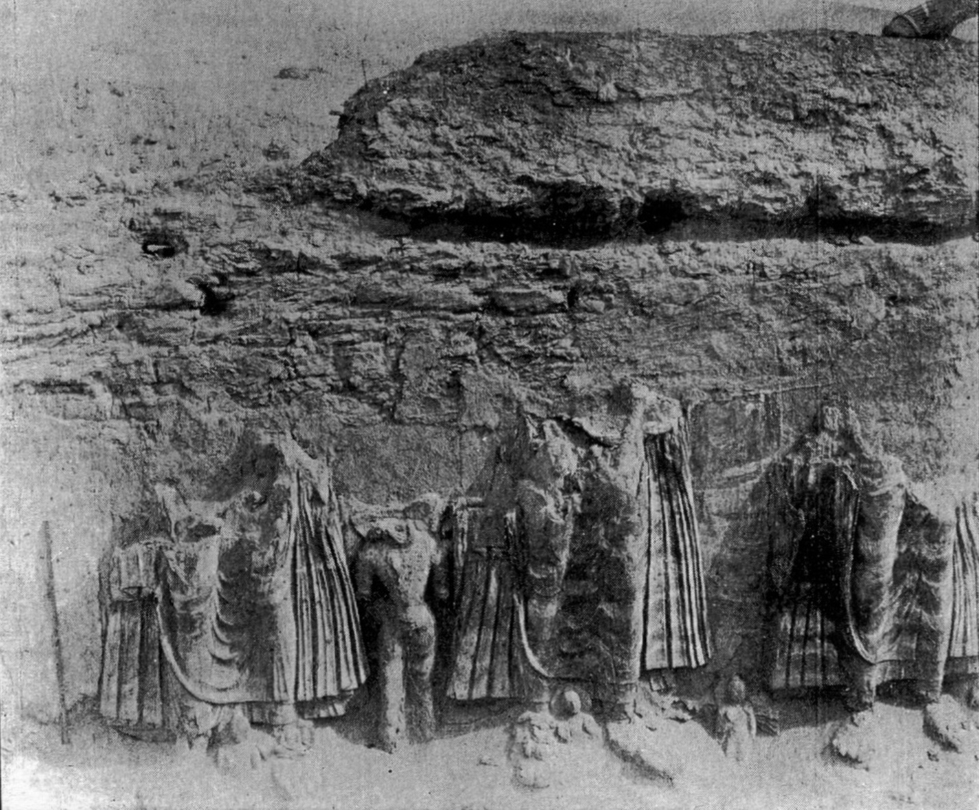
What Stein found most interesting was not the stupa itself but the sculptures decorating the walls of the courtyard that had been buried in the sand for centuries if not millennia. The geometry of the site is perhaps even more remarkable. The axes of the stupa and its quadrangular enclosure are rotated too far away from the cardinal directions to be aligned to the sun (solstices) or moon (lunar standstills). However, like Tashkurgan, if we assume a different reference frame, the southwest-northeast axis turns out to be very closely aligned in the direction of major lunar standstills relative to the Hudson Bay pole placing its origin in the same epoch as Tashkurgan – at least 12,000 to 18,000 years ago.


3. Endere
Continuing west to east, an extensive array of ruins can be found in Endere including an ancient fort and Buddhist temple. Stein’s exploration of the fort raised more questions than answers:
During the days following I had almost all the buildings within the enclosing ramparts cleared of sand. These excavations furnished interesting data as to the methods of construction employed, but failed to throw much light on the original destination of the whole of this ruined settlement. The large brick building to the east of the temple, of which a portion left exposed by the sand occupies with its massive walls of sun-dried bricks three sides of a quadrangle over 100 feet square. The dimensions of its rooms suggest public use; but as, with the exception of a walled fireplace or two, they were found completely empty, there was nothing to prove the true character of the structure. Were these the quarters of a well-to-do monastic establishment which found it advisable to protect itself by walls and ramparts? Or do the latter mark a fortified frontier-post which sheltered also a Buddhist temple?
Where Stein felt that he “had reached the border-line beyond which Indian influences yielded to Chinese,” other structures at Endere seem to straddle an even more ancient border-line between history and prehistory.


Surviving features of the fort (top right) are aligned in the direction of the geomagnetic pole circa 200 BCE, which corresponds to the period when the area was under the control of the Han Dynasty. A stupa northwest of the fort (bottom right) appears to be aligned in a different direction that corresponds to the direction of major lunar standstills relative to the Hudson Bay pole. Nearby ruins (left) are cardinally aligned (N-S-E-W) relative to the same pole suggesting these structures could be considerably older than the fort.

4. Miran
The pattern of structures aligned to the Hudson Bay pole extends to Miran, at the eastern end of the Taklamakan Desert. At Miran, Stein first encountered four ancient structures including two stupas – one “well-preserved” and the other “much decayed.” Two remaining ruins were “square structures solidly built in sun-dried bricks of unusual hardness.” Visible structures appear to be rotated slightly west of north in the direction of the Hudson Bay pole.
About a kilometer east of these ruins, lies an ancient Tibetan fort that Stein found to be less than remarkable, stating “the crumbling walls and bastions were massive enough in dimensions, but their inferior construction seemed to suggest a relatively late date.“ Less than 2 km northeast of the fort he found a ruined temple in which he uncovered an enormous Buddha head. Based on his findings Stein concluded that “the temple dated from a period far more ancient than that ascertained for the Tibetan fort. A number of observations made it appear a priori probable that a site of considerable antiquity had been reoccupied here, as in the case of Endere.”

5. Discussion
The above table summarizes the alignments of these and other ancient sites in the Taklamakan Desert and surrounding regions. Most of the sites appear to reference previous poles, especially the Hudson Bay pole. This is particularly interesting as it extends a pattern discussed in previous articles that appears to stretch from the Arabian Peninsula, through India, into and now across Central Asia. That the alignments of so many structures appear to reference the Hudson Bay pole supports the hypothesis that these sites were first established by an earlier pre-cursor civilization that existed in this part of the world no less than 12,000 to 18,000 years ago (Carlotto 2022). Although this hypothesis explains the alignment of these sites in a simple way it does not account for the alignment of all of the sites in the region or the possibility that some of the sites might have been aligned in other ways such as to the geomagnetic pole, a possibility that will be considered in a forthcoming article.
Feature image at the top of the article of the Rawak stupa is courtesy of The International Dunhuang Project.
Discover more from Before Atlantis
Subscribe to get the latest posts sent to your email.


I couldn’t refrain from commenting. Exceptionally well written!
LikeLiked by 1 person
Khotan isn’t before Atlantis. It could be Atlantis!! Plato’s description of the plain Atlantis had forms an eye shape like the Taklamakan desert. We know this because he said the plain would be rectangular and oblong. The definition of oblong means something that is elongated. We know if it was a rectangle it would already be elongated. because that’s what a rectangle is, it’s an elongated square. So there wasn’t a need for him to say it was oblong. Unless he was trying to describe a shape that he didn’t have a direct word for like oval because it wasn’t invented yet. He could have said it was circular and oblong but he didn’t for some reason. He did go and say that there was a ditch that followed the plain that was circular. Indicating that the plain itself was circular and oblong. He then said the plain was surrounded by mountains. The Taklamakan desert is also surrounded by mountains. Which makes me believe more that it is the plain of Atlantis.
LikeLike