


In The Pyramid Network – Part I, The Valley of Mexico Marco Vigato identifies a collection of archaeological sites in and around Mexico City that appear to be aligned to one another. Although they are generally regarded to be of Aztec, or more broadly Nuaha origin, an examination of these sites in the context of our Before Atlantis hypothesis suggests that they could be much older.
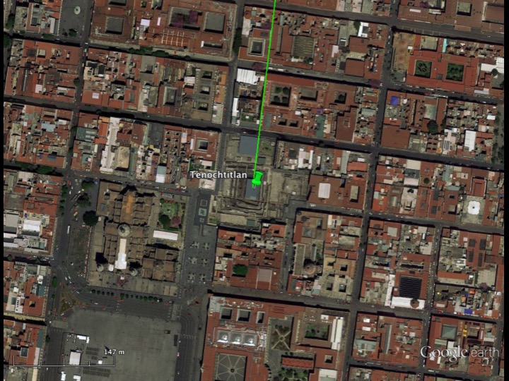
Tenochtitlan
Beginning around 500 CE waves of Nahuatl-speaking people began to migrate into the Valley of Mexico from the north. The last wave who called themselves the Mexica arrived on a marshy island in Lake Texcoco known as Tenochtitlan at a spot that, according to legend, had been pre-ordained by Huitzilopochli, the Aztec god of the Sun and war. There they built a pyramid with twin temples on the top – one dedicated to the rain god Tlaloc and the other to Huitzilopochli.

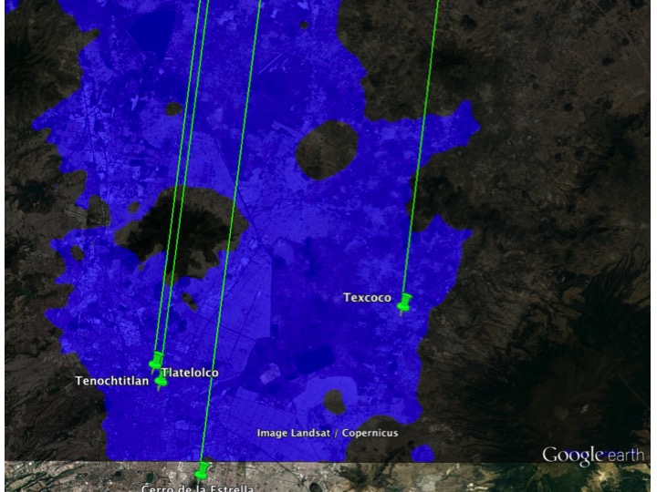
By the time of the Spanish Conquest this structure, which is now known as Templo Mayor at the heart of modern-day Mexico City, had been expanded a number of times, each time preserving the original design with later pyramids built over and around the original pyramid in a manner not unlike that of a Russian nesting doll. Pyramids of similar design were built at Tenayuca, Acatitlan, Tlatelolco, and Texcoco.

An unsolved mystery of Templo Mayor and the surrounding area in Mexico City is why they are misaligned with respect to the cardinal directions – north, south, east, and west – by approximately 6.5° south of east.
According to a Spanish friar who arrived in Mexico soon after the Conquest, the Aztec feast of Tlacaxipehualiztli “took place when the sun stood in the middle of [the Temple of] Huitzilopochtli, which was at the equinox, and because it was a little out of line, [King] Moctezuma wished to pull it down and set it right” (Aveni 2001). One explanation for why Templo Mayor is not aligned due east-west is that it had to be rotated to compensate for the elevation of the sun by the time it had risen high enough to be seen between the two temples at the top of the pyramid.
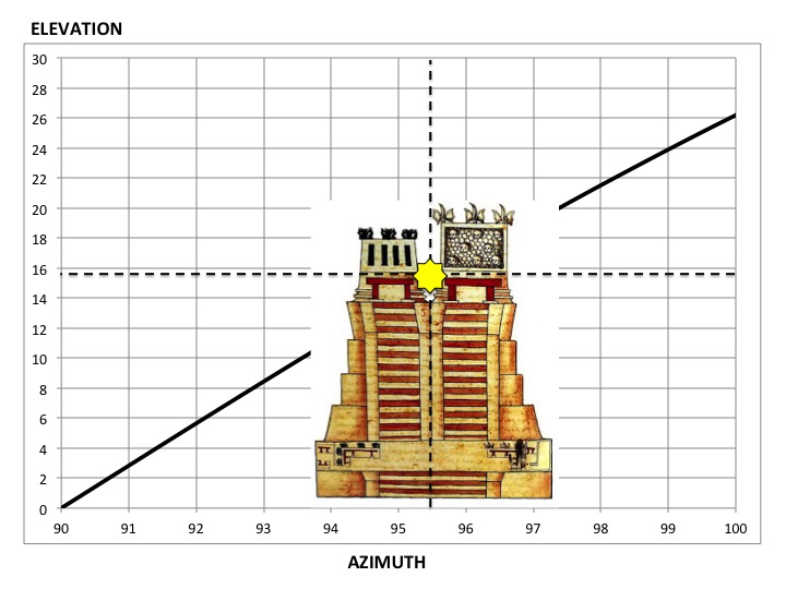
If this explanation were correct, as the structure was expanded, the rotation angle of the later phases should be greater than the rotation angle of earlier phases. The following measurements made by Sprajc (2000) give the orientations of the north-south, east, and west-facing sides of Templo Mayor.
Phase II:
East: 97°42'±30'
West: 277°42' ± 30'
North-South: 6°30' ± 1°

Later phases:
East: 95°36' ± 30'
West: 275°36' ± 30'
North-South: 6°40' ± 30'
Notice the east orientation of the Phase II structure is greater (not less) than the east orientation of later phases. Although later phases of the pyramid may have been rotated under Moctezuma’s rule to make it line up, the Phase II temple could not have been aligned to the equinox.
Various researchers have suggested other possible explanations for the orientation of Templo Mayor (and other pyramids) related to important Aztec calendar dates, agricultural cycles, and horizon features such as mountain peaks. Before considering another explanation, let us examine several nearby sites.
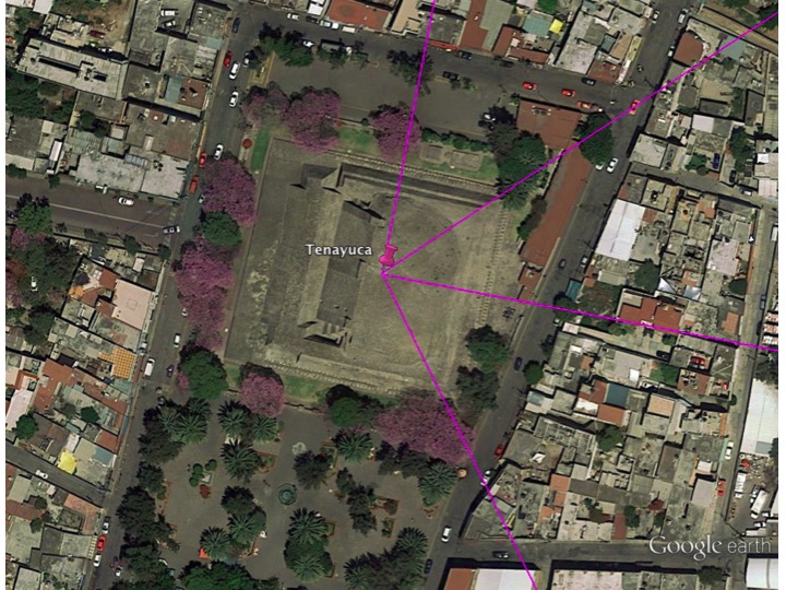
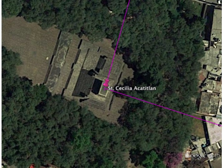
Tenayuca and Acatitlan
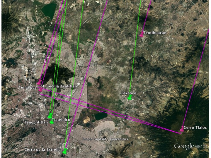
Due to the similarity in design, it is generally assumed that Templo Mayor was modeled after the pyramid of Tenayuca to the north. The orientation of this pyramid is quite interesting. Like Templo Mayor it is rotated clockwise but by a different amount. The east-facing side of the pyramid points directly toward the peak of a currently extinct volcano known as Cerro Tlaloc, 31 miles to the east-southeast. The diagonals of the pyramid closely align with Teotihuacan to the northeast and Cerro de la Estrella to the southeast. It turns out that structures at all three of these sites are aligned in the same direction, approximately 15.5° east of north. Another pyramid at St. Cecilia Acatitlan that has undergone extensive reconstruction a short distance to the north of Tenayuca is also oriented in this direction and faces Cerro Tlaloc.
Tlatelolco
Twelve years after it was founded, a group of dissident Mexica left Tenochtitlan to settle on a marshy island to the north that had been previously occupied by earlier waves of Nahua who had migrated to the Valley of Mexico. Over time, this settlement came to be known as Tlatelolco, which means “a built-up mound of earth.” Interestingly the alignments of some structures at Tlatelolco are similar to those at Tenochtitlan. The Temple of the Calendar and the Temple Of Ehecatl-Quetzalcoatl closely line up with the north-south alignment of 6.5° measured at Templo Mayor. On the other hand, the pyramid at Tlatelolco that is similar in design to Templo Mayor is rotated even further clockwise, 8 to 9°. Like Templo Mayor was this structure also rotated so that the sun would be seen to rise in between the twin temples at the top of the pyramid at the time of the equinox? If so the increased rotation angle of the structure implies that it was taller than Templo Mayor, which is unlikely (Marco Vigato, private communication).

Texcoco
A twin pyramid similar to those at Tenochtitlan, Tlatelolco, Tenayuca, and Acatitlan once existed in the ancient city of Texcoco, which was east of Lake Texcoco. Among the above-ground ruins in modern-day Texcoco, those at Los Melones appear to be oriented in the same direction as Tenochtitlan and Tlatelolco.

A Far More Ancient Origin?
Unlike Tenayuca and Acatitlan, neither Templo Mayor nor Tlatelolco directly face in the direction of Cerro Tlaloc.
In Before Atlantis we propose that a series of crustal displacements shifted the North Pole four times over the past 125,000 years, first from the Bering Sea north of the Aleutian Islands to a location in the Norwegian Sea 125,000 years ago, then to northern Greenland 75,000 years ago, then to a location east of Hudson Bay in Canada 50,000 years ago, and to finally to its present location in the Arctic 12,000-18,000 years ago.
Notice in Sprajc’s measurements that the north-south alignment of both the Phase II and later phases of Templo Mayor is the same – approximately 6.5° east of north. As noted above Tlatelolco, Los Melones, and an early structure atop Cerro de la Estrella (discussed later) are also aligned in the same direction, a direction that faces a hypothesized prior location of the North Pole in Greenland. We propose that the original structures at these sites were built by a much earlier, prehistoric civilization that inhabited the Valley of Mexico when the North Pole was in Greenland, some 50,000 to 75,000 years ago.

The pyramids of Templo Mayor at Tenochitchan, Tlatelolco, Texcoco, Tenayuca, and Acatitlan were all of the same design. That the orientation of the pyramids at Tenochitchan, Tlatelolco, and Texcoco are different from those at Tenayuca and Acatitlan suggests there were different alignment schemes. Both of these schemes are evident in the two superimposed sets of orientations present in a structure atop Cerro de la Estrella. The alignment of the bottom (earlier) structure (in green) like Tenochitchan, Tlatelolco, and Texcoco is toward the Greenland pole. The structure above it (in magenta) is, like that of Tenayuca and Acatitlan, oriented toward the Hudson Bay pole.

A Prehistoric Timeline
If structures in Tenochitchan, Tlatelolco, Texcoco, and Cerro de la Estrella were first built when the North Pole was in Greenland, the latitude of the Valley of Mexico would have been about 10° further north than it is now with a climate similar to that in northern Mexico or the southwest US.
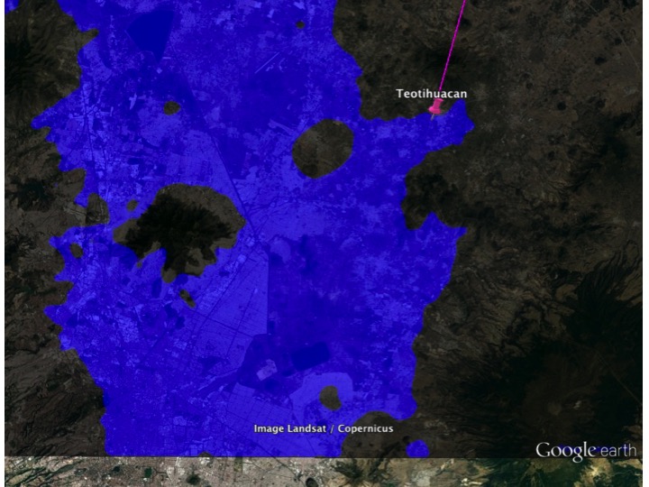
Several tens of thousands of years later, during the last glacial period in North America, the Valley of Mexico had a temperate climate and Lake Texcoco was much larger than it was at the time of the Spanish Conquest. Teotihuacan, which translates as “birthplace of the gods” in the Nahuatl language was also known to the Mayans as the “place of reeds” and suggests that the site was once on or near the shoreline of Lake Texcoco. This is consistent with the climate-change consequences of a pole shift from Greenland to Hudson Bay that would have moved the Valley of Mexico 20° further north well into the temperate climate zone. With a climate similar to that in northern Canada, fed by snowmelt and rain runoff from the surrounding mountains, Lake Texcoco could have been much larger than it ever was during the historical period reaching as far north as Teotihuacan.
Site                              Elevation
Cerro Tlaloc                      4124
Cerro de la Estrella              2404
Teotihuacan                       2280
Texcoco                           2263
Acatitlan                         2266
Tenayuca                          2254
Tlatelolco                        2233
Tenochtitlan                      2232
After the Greenland to Hudson Bay pole shift, much of what is now Mexico City and what was then the first settlements at Tenochitchan, Tlatelolco, and Texcoco would have been flooded, submerged, and eventually forgotten.
At Teotihuacan, an enormous statue dedicated to the water goddess Chalchiuhtlicue was found within the Pyramid of the Moon. Chalchiuhtlicue was the fourth Sun in the Aztec myth of the Five Suns and is associated in with the time when the North Pole was in Hudson Bay. In an earlier post we showed that based on archaeoastronomy evidence, the Pyramid of the Moon might have been the first structure built at Teotihuacán approximately 35,000 years ago.
The last violent eruption of Cerro Tlaloc is estimated to have occurred 21,000 to 25,000 years ago (Macías et al 2012). It is possible that by this time the water level of Lake Texcoco had fallen somewhat exposing more land in the Valley of Mexico. We propose that following the eruption of Cerro Tlaloc the first structures were built at Tenayuca and Acatitlan near the shoreline (Acatitlan is translated as “the place among the reeds”) and positioned to be in alignment both with the Hudson Bay pole to the north and Cerro Tlaloc to the east. Cerro de la Estrella also could have been modified at this time.

The last crustal displacement shifted the North Pole from Hudson Bay to its current position in the Arctic and thrust the Valley of Mexico more than 40° south from a cool temperate climate to a dry arid one. The effect of such a large displacement in this part of the world probably devastated the civilization that had developed here when the North Pole was in Hudson Bay.
After the pole shift as the climate warmed the water level began to drop revealing ancient shoreline and islands that had been submerged for thousands of years. When the Nahua people entered the Valley of Mexico in historical times we propose that they found the remains of these two previous civilizations in the form of ancient architecture aligned in non-cardinal (and non-astronomical) directions. Teotihuacanos co-opt Teotihuacan, the Chichimec Tenayuca, and so on. The Mexica build Templo Mayor patterned after the design of Tenayuca over ruins oriented in the direction of the old Greenland pole, which was considered sacred by virtue of its alignment with Cerro Tlaloc.
Conclusion
The Aztecs had set out to find a place marked by an eagle sitting on a cactus eating a serpent. We propose that they also found the ruins of pre-existing structures that had been built tens of thousands of years earlier by an unknown prehistoric civilization. Establishing a pattern that would be repeated many times, they built their first temple over the old.
Although the pre-existing ruins were aligned to the Greenland pole, which is associated with the Third Sun Tlaloc, the Mexica’s reverence for both Tlaloc and Huitzilopochtli required a structure that would reference both deities. The original temple aligned to the Greenland pole was rebuilt and rotated slightly north to align to the equinox sun at the point where it would be seen between the two temples.
References and Sources
Anthony Aveni, Skywatchers of Ancient Mexico, Austin and London: University of Texas Press, 1980), 236–238.
Manuel Aguilar-Moreno, Aztec Architecture – Part 1
Manuel Aguilar-Moreno, Aztec Architecture – Part 2
Discover more from Before Atlantis
Subscribe to get the latest posts sent to your email.


One Reply to “”