


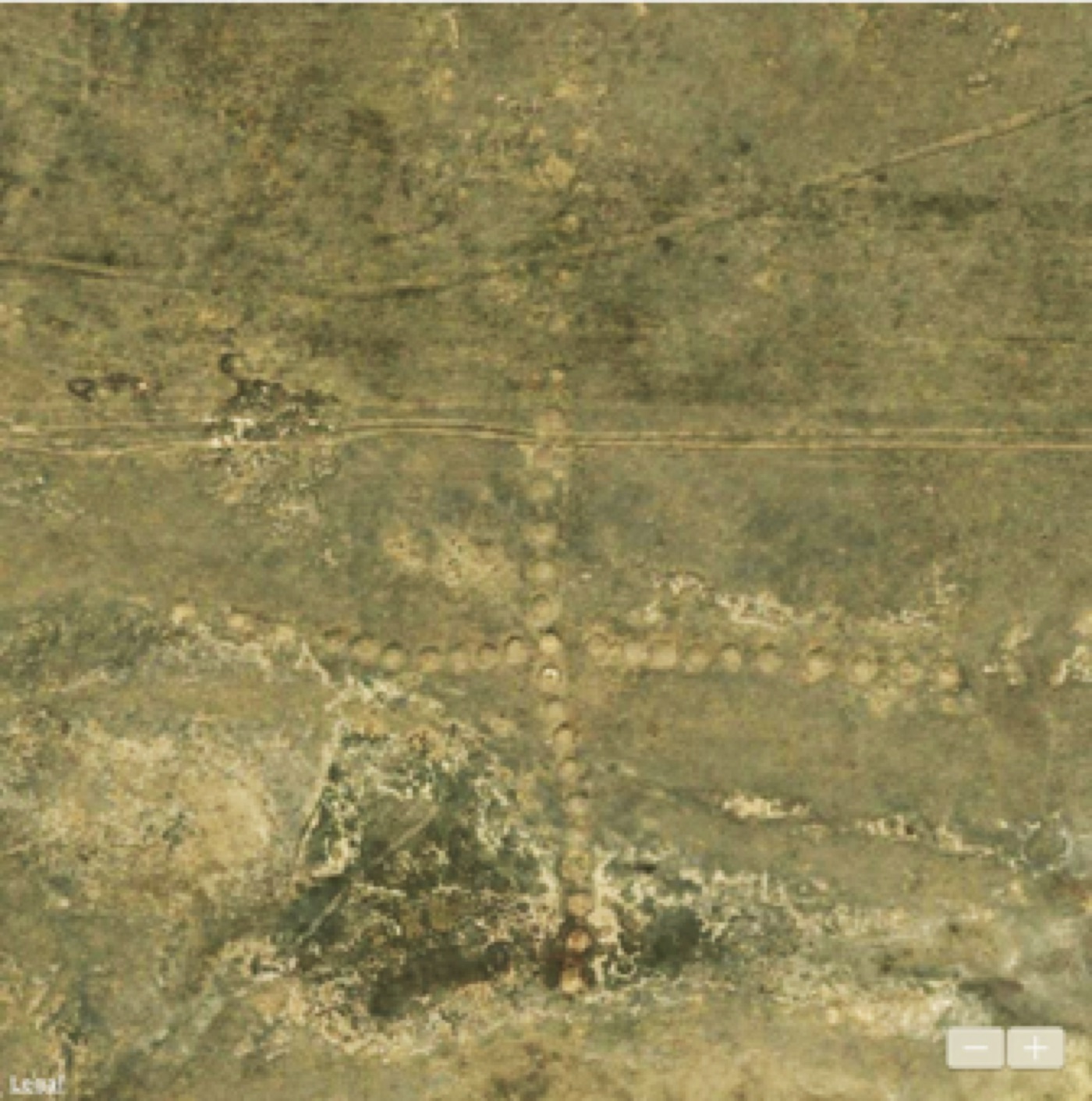
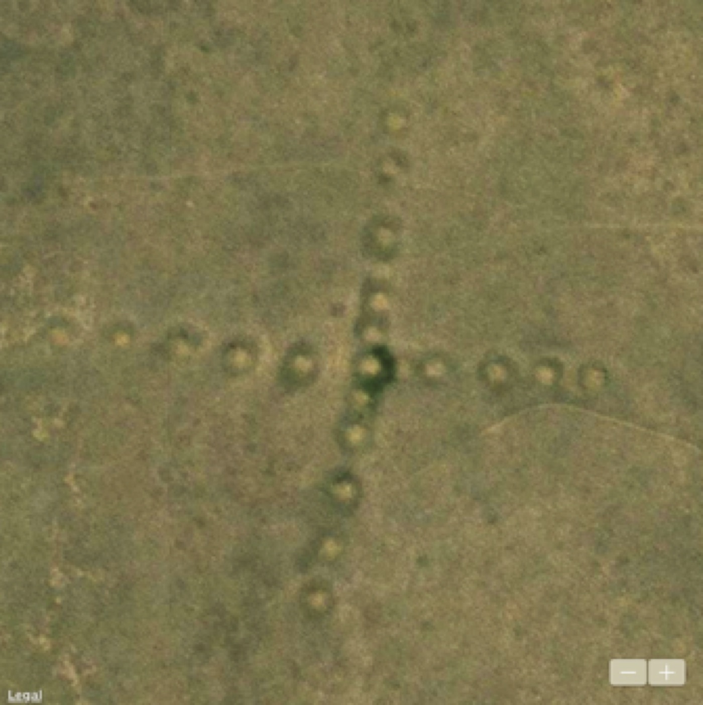
In 2007, Dimitriy Dey discovered a large number of “geometric earthworks” in the steppes of northern Kazakhstan including linear arrangements of earthen mounds, cross figures, squares, and other shapes. These features are found at points of high relief, such as on plateaus and river divides. Like the Blythe Intaglios in California along the Colorado River and other geoglyphs discussed in previous articles, those in Kazakhstan can only be seen from above.
Alignments of Earthwork Crosses to Solstices
Six of the Torgai geoglyphs are cross-shaped: Akshiganak, Kara-Torgai, Zharsai, Ashutasty, South Torgai, and Makhsat. The Ashutasty and South Torgai crosses have bent and curved arms that make it difficult to determine their orientation. The Makhsat cross is also irregular and bisected by a paved road. It is not immediately evident that the other three crosses rotated 9° to 13° from north are aligned in any obvious direction, astronomical or otherwise.


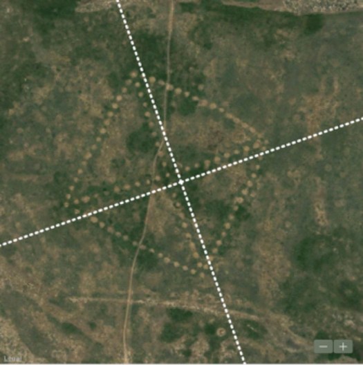
In an attempt to understand their orientation an interesting alignment has been discovered. Instead of using the arms to define the direction of a cross, consider the series of lines that pass through successive pairs of mounds equally spaced from the center.
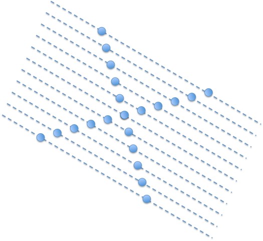
The Akshiganak Cross is rotated approximately 13° counterclockwise relative to the cardinal directions. If a cross were aligned to the cardinal directions lines passing through successive pairs of mounds emanating from the center would run from 135° to -45°. Subtracting the 13° counterclockwise rotation of the Akshiganak Cross produces a series of equally spaced lines running from 122° to -58° or from 32° south of east to 32° north of west. At this latitude, these lines lie in the direction of the winter solstice sunrise and summer solstice sunset circa 7200 BCE.
The Kara-Torgai and Zharsai crosses are rotated clockwise relative to true north. The Zharsai Cross is rotated 11° east of north. Lines passing through pairs of mounds along the northern and western arms run from 56° to -124° or 34° north of east to 34° south of west and lie in the direction of the summer solstice sunrise and winter solstice sunset circa 3880 BCE. The Kara-Torgai Cross is rotated by a lesser amount, 9.2° east of north, and so it’s dating is more recent around 900 BCE.
Using changes in the earth’s obliquity to date the crosses, we hypothesis that the Akshiganak and Zharsai crosses are more ancient than the Kara-Torgai Cross. The Akshiganak and Zharsai crosses also appear to be better executed than the Kara-Torgai Cross, which contains unmatched mounds just above and below the central mound. Even more irregular in shape, neither the Ashutasty nor the South Torgai crosses would have been able to function as solstice markers. Optically stimulated luminescence (OSL) dating of the Ashutasty Cross is early Iron Age around 800 BCE (Matuzeviciute et al 2015). If their intended purpose were to function as solstice markers one could conclude that the astronomical knowledge used to construct the Akshiganak, Kara-Torgai, and Zharsai crosses was lost by the first century BCE.
Alignments to Other Places
That the oldest astronomically dated cross figure appears to be the best executed suggests the possibility that some of these figures could have been built by an earlier pre-Iron Age civilization. In the 1970s, Viktor Sarianidi discovered the ruins of an ancient civilization that he termed the Bactrian-Margina Civilization also known as the Oxus Civilization centered in the Murghab Oasis, Turkmenistan and dated to the Bronze Age, 2200-1700 BCE (Lamberg-Karlovsky 2013).
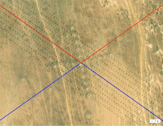
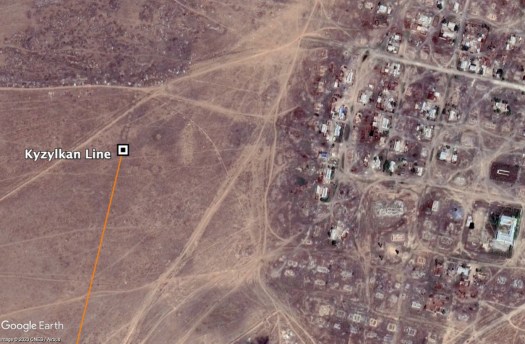
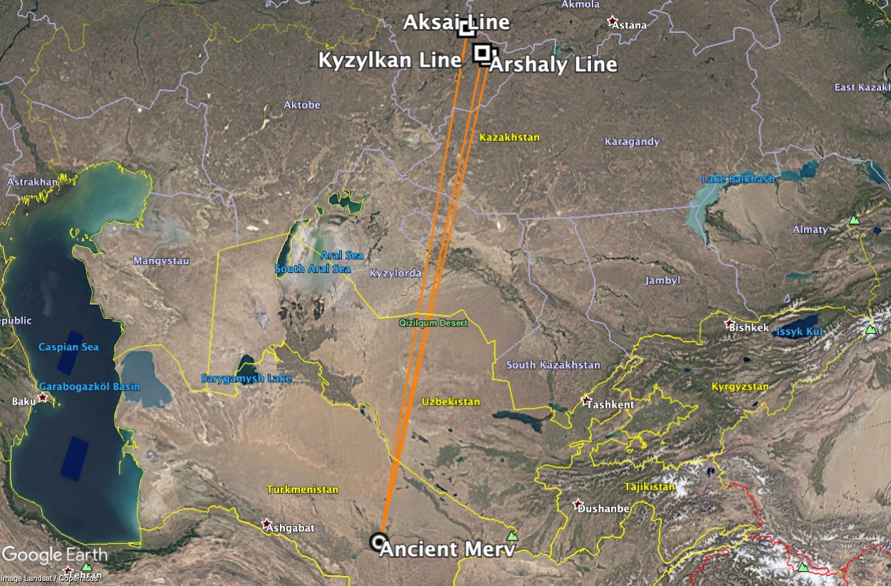
In a study of the alignment of ancient sites in Greece, it was determined that either the ancient Greeks or their ancestors aligned certain temples to face older oracle sites as far as 700 miles away (Carlotto 2019). Here we have found that the Kyzylkan Line and the nearby town of Tasty, the Arshaly Line, and possibly the Aksai Line appear to point to the direction of the ancient city of Merv over 900 miles to the south-southwest.
Earthwork Alignments to Previous Poles
The Ushtogaiskii Square, which is perhaps the most unique and sophisticated of the earthen structures appears to be deliberately facing a particular direction, but unlike the crosses analyzed in the previous section, it is rotated too much to be aligned to the sun or moon.
Thousands of years before Abu Rayhan al-Biruni’s earliest geodesy algorithms for calculating Islamic qibla (Nasr 1976), there is no evidence that a Bronze Age civilization in this or any other part of the world was capable of aligning sites hundred of miles apart to one another. If the alignment of these three geoglyphs to Merv is not a coincidence, then such knowledge must have been inherited from an even earlier prehistoric civilization.
We have found that four of the Torgai geoglyphs appear to be aligned to three former pole locations. According to Hapgood’s theory, the North Pole was located in Hudson Bay 12,000 to 18,000 years ago (Hapgood 1958). Ushtogaiskii Square and a rectangular structure approximately 62 miles to the southeast are aligned to the Hudson Bay pole. By virtue of its alignment to the Hudson Bay pole, we propose that Ushtogaiskii Square was built tens of thousands of years ago by an unknown prehistoric civilization. The Kandy and Kara-Torgai lines could be even older. The Kandy Line is aligned perpendicular to the Norwegian Sea pole, which is thought to have been the location of the North Pole before Hudson Bay approximately 60,000 years ago. The Kara-Torgai Line is aligned in the direction of an even earlier pole in Greenland estimated to have existed 80,000 years ago.
Summary
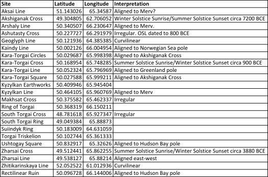
As shown in the above table only one geoglyph is aligned in the cardinal directions. Three could have functioned as solstice markers, two or possibly three appear to point to the ancient city of Merv, one to another geoglyph, and four to previous locations of the North Pole. Together, these explanations account for the alignment of most of the geoglyphs examined except for the curved and irregularly shaped including the ring geoglyphs and the “Torgai Triskelion.” The presence of more and less precise geometries aligned in different ways suggests that the geoglyphs were not the product of a single period or civilization but were created over an extended time with earlier figures more precisely aligned and better executed than the later ones.
References
Mark Carlotto (2019) “New Models to Explain the Alignments of Greek Temples,” SSRN http://dx.doi.org/10.2139/ssrn.3501950.
Charles Hapgood (1958) The Earth’s Shifting Crust: A Key To Some Basic Problems Of Earth Science, CreateSpace.
C.C. Lamberg-Karlovsky (2013) “The Oxus Civilization,” CuPAUAM39, 2013: 21-63 ISSN 0211-1608 22.
Motuzaite Matuzeviciute, A.V. Logvin, I. Shevnina, A.M. Seitov, J. Feng, and L. Zhou (2015) “OSL dates for the ancient geometric earthworks of Kazakhstan,” Archaeological Research in Asia, http://dx.doi.org/10.1016/j.ara.2015.12.001.
Seyyed Hossein Nasr (1976) Islamic Science: An Illustrated Study, World of Islam Festival Publishing Company Ltd.: 92-93.
Acknowledgement
Featured image at the top of the article is courtesy CNES/Airbus/Google Earth.
Discover more from Before Atlantis
Subscribe to get the latest posts sent to your email.

