


The term geoglyph has become synonymous with almost any kind of large organized pattern on the ground. Some are the remains of ancient structures long since abandoned, others were created to express an idea, perhaps even to communicate some kind of message. Most defy explanation either in terms of what they represent or attempt to communicate, how they were constructed, or for whom were they intended.
A previous post examined a geoglyph known as the Badlands Guardian east of Medicine Hat, in Alberta, Canada. The Badlands Guardian is thought by many to be simply an example of a hollow-face illusion resulting from natural erosional processes. We showed that this feature is oriented to the cardinal directions and by virtue of its orientation with respect to the path of the sun will tend to maintain its facial appearance over the course of the year.
In this article, we discuss the alignment of other geoglyphs aligned to the poles (i.e., north-south) and to other geographic locations.
Directional Markers in the Southern Hemisphere
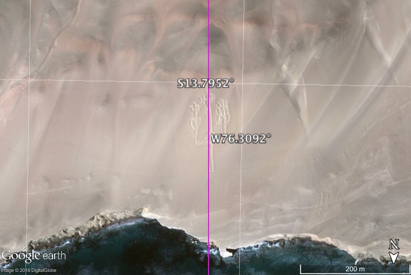
Those of us who live in the northern hemisphere forget that the southern hemisphere currently has no pole star. The Paracas Candelabra is on the north side of a hill on Peru’s Paracas Peninsula. Lacking a celestial reference to north, the Candelabra faces within a couple of degrees of due south (Figure 1). Almost two hundred meters tall, the geoglyph would have provided ancient mariners with a directional reference that can be seen twenty kilometers out at sea.
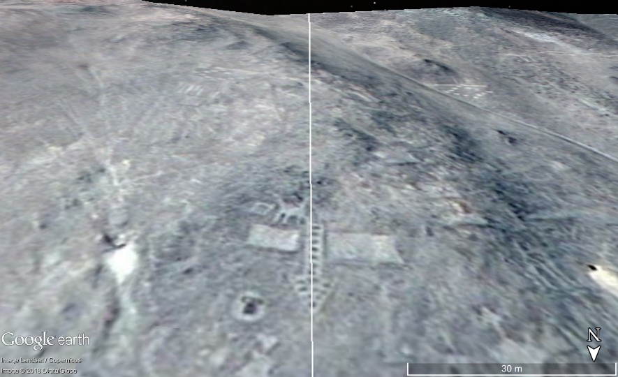
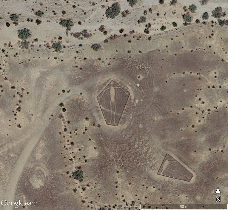
More than a thousand kilometers southeast of Paracas in the northern Atacama Desert near the town of Pintados Chile lie an assortment of geometric, anthropometric, and animal forms on the side of a hill. These figures are smaller, on the order of tens of meters in size. One is an arrow that points due south (Figure 2).
Unlike these features rendered on hillsides that can be seen at ground level, the following geoglyphs can only be seen from above.
Blythe Intaglios
The Blythe Intaglios are a number of large biomorphic glyphs etched into the ground in California along the Colorado River. Three are humanoid forms with outstretched arms. One is aligned to the north (Figure 3). A second figure is aligned with a third that, in turn, points north, northeast. There is also a fourth humanoid figure forty kilometers due east in Bouse AZ that faces south.
None of these figures can be fully visualized at ground level. There are no hills high enough or close enough to be able to see these features from above. The inescapable conclusion is that they were built for someone who could view them from the air.
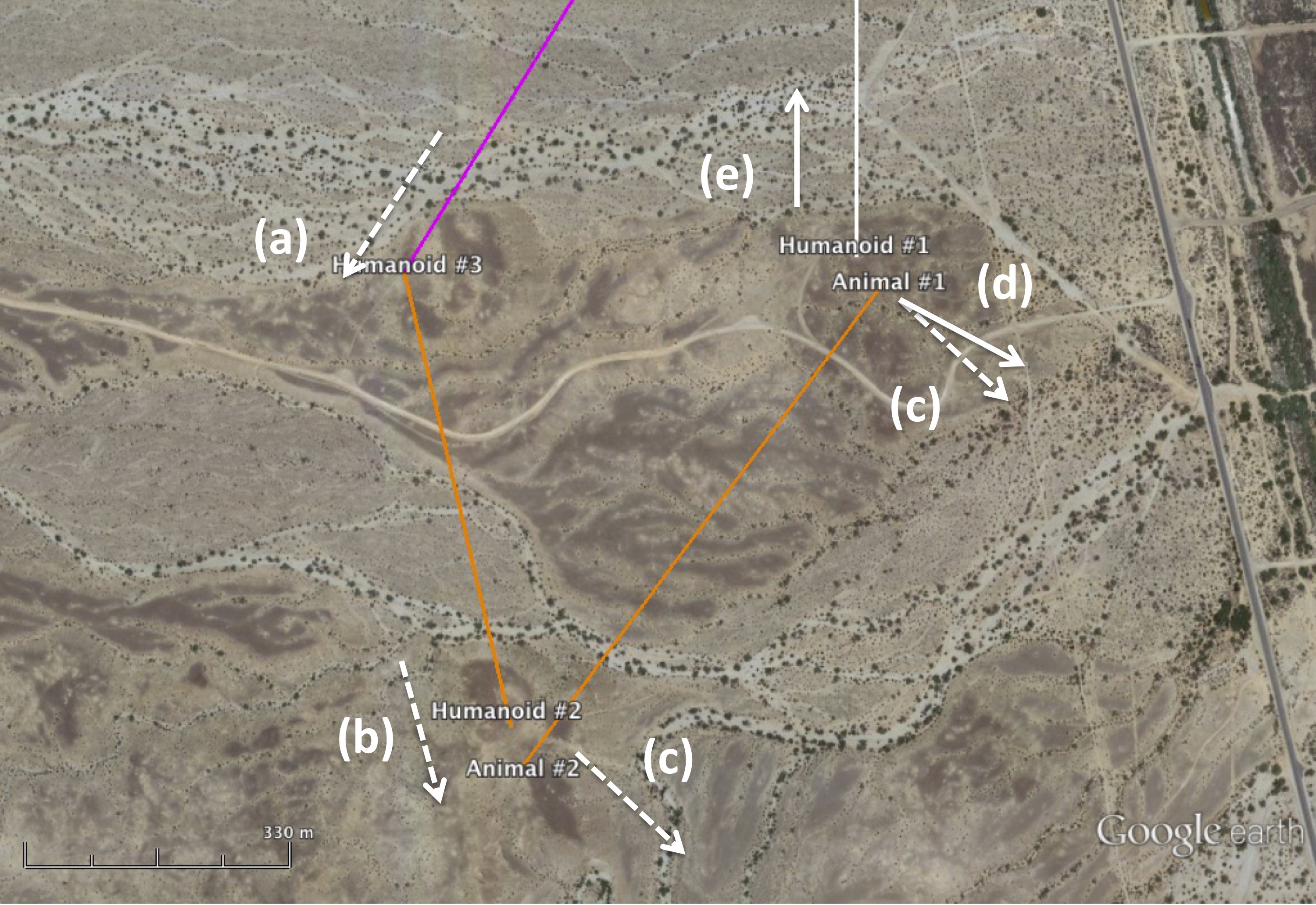
Charles Hapgood proposed that the ice ages were caused by shifts in the geographic location of Earth’s poles. He hypothesized that the North Pole was near Hudson Bay during the last ice age. Figure 4 summarizes a series of inter-related alignments. The third humanoid figure mentioned above that points north, northeast is aligned to the Hudson Bay pole, which is approximately 31° east of north. The figure (a) is upside down with its feet facing the former pole. The second humanoid mentioned earlier and an adjacent animal figure are both in line with the third figure (a). The feet of the second figure face the third figure (b). It can be shown that this angle was in the direction of the winter solstice sunrise/summer solstice sunset when the North Pole was in Hudson Bay. This angle is approximately 43° south of east, which is greater than the current solstice angle of 28°. The difference is due to the fact the latitude of the site changed after the Hudson Bay pole shift. The animal figure (c) is rotated counterclockwise relative to (b). The first humanoid figure (e) is aligned to north. The adjacent animal figure is aligned in the current solstice direction (d) as shown in Figure 3. The difference in alignment between the two animal figures (c) and (d) is approximately 15°, which is equal to the difference between the solstice angles.
According to Hapgood, during the last ice age when the North Pole was in Hudson Bay, this part of the United States was ice-free with a much more temperate climate than it has today. Thus, unlike other parts of North America, the Southwest has probably been inhabited continuously for tens of thousands of years. Perhaps the alignment of these geoglyphs along with what they represent might be able to tell us something about the history of this part of the world over this period of time.
Nazca Lines
In Before Atlantis it was shown that the two brightest Nazca lines are aligned to two former hypothesized pole locations in the Bering Sea and the Norway Sea. Numerous sites in Peru including the ancient city of Cuzco were also once aligned with the Bering Sea pole.
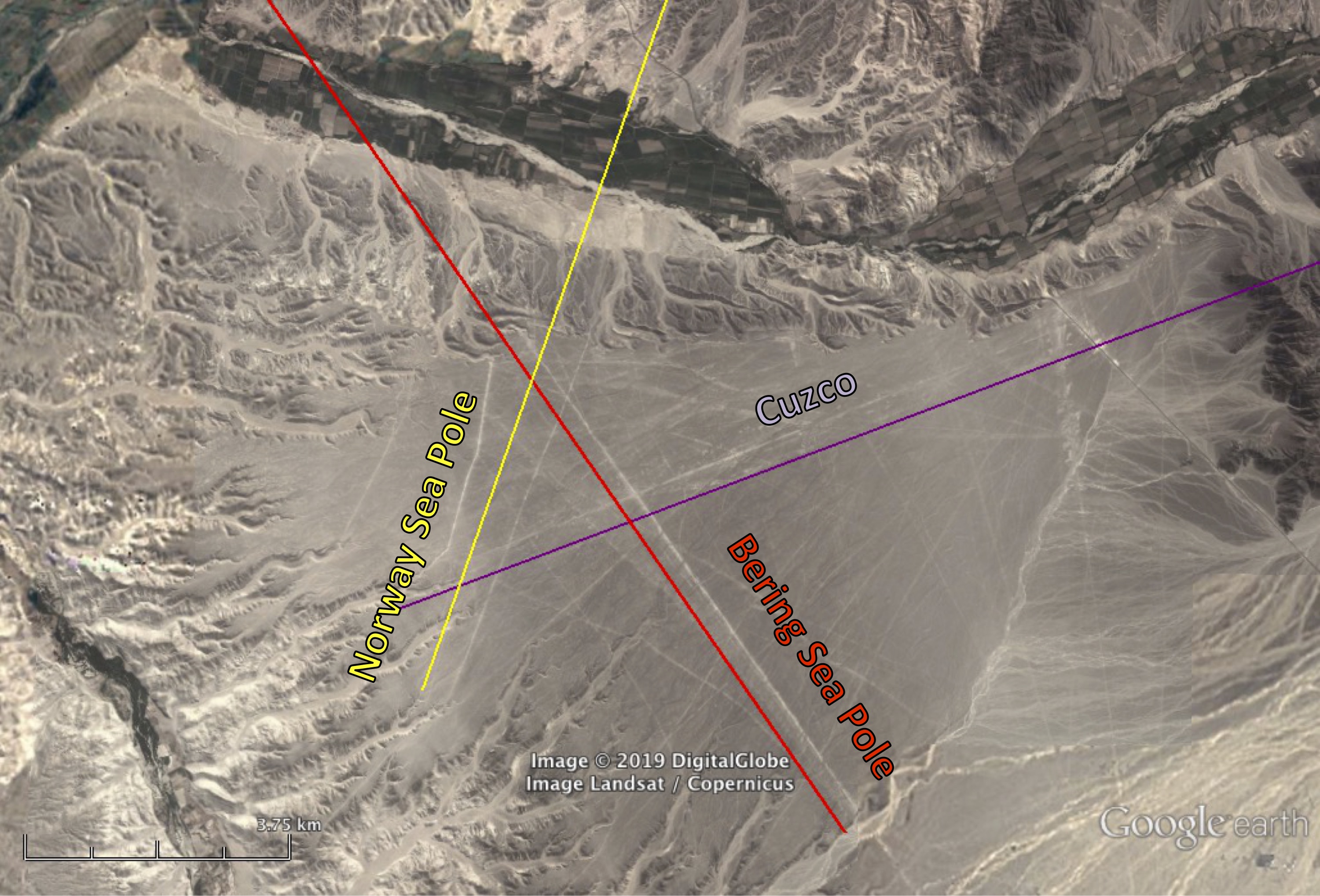
Although many explanations have been proposed for the alignments at Nazca, none have considered their relation to other sites, other geographic locations. Figure 5 shows the correlation of Nazca lines with the direction of the two former poles mentioned above and the city of Cuzco some 370 kilometers east, northeast of Nazca. One can find numerous linear features along the purple line that are oriented toward Cuzco.
An examination of the orientation of Nazca’s zoomorphic geoglyphs reveals that seven appear to be oriented with respect to Cuzco as well (Figure 6). The human figure sometimes called the Astronaut (top photo) faces toward Cuzco, as does the Heron. The Condor seems to be flying at a right angle relative to the direction Cuzco. The Dog and Parrot face away from Cuzco. The Spider is also aligned in the same general direction as is the Tree.
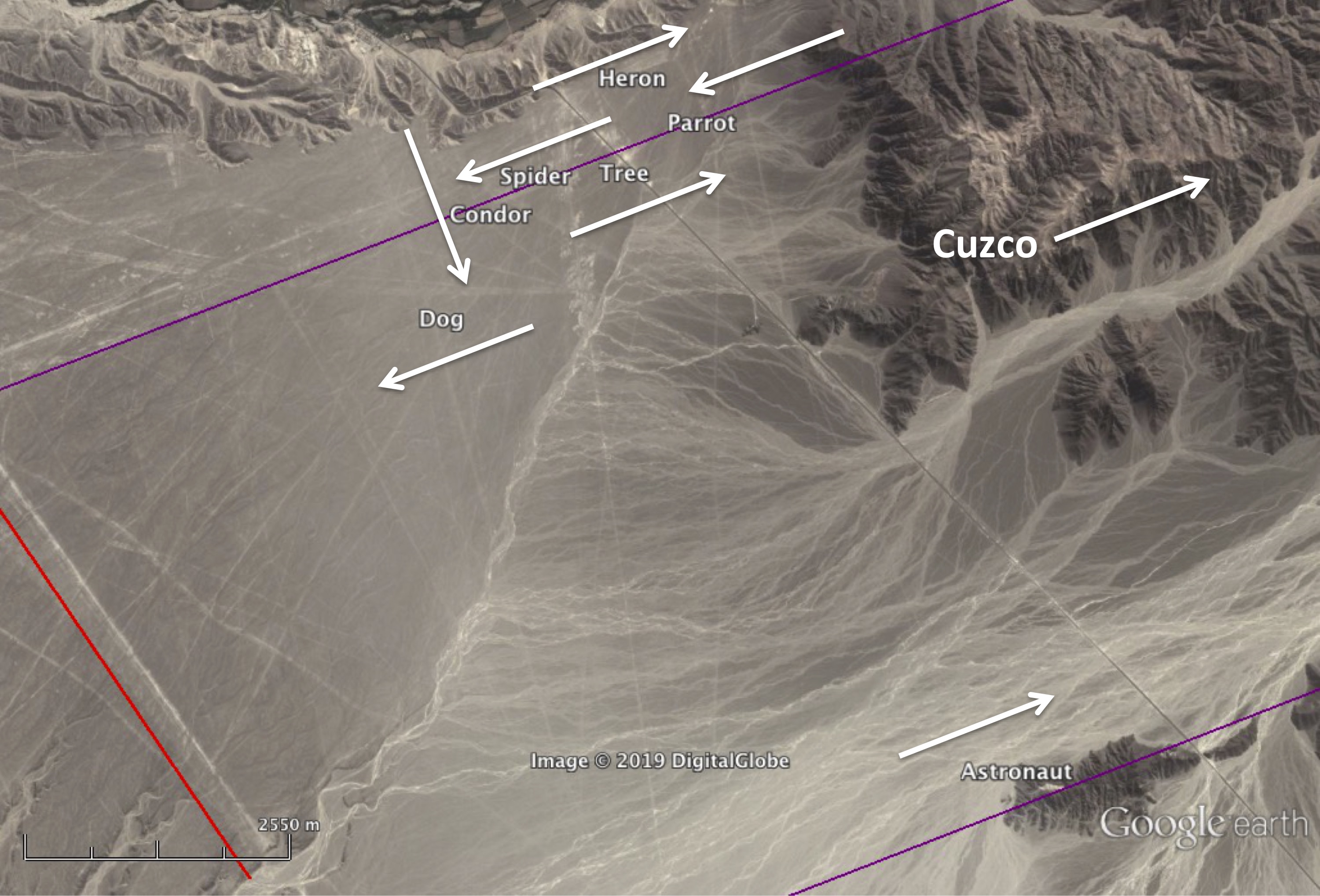
That at least some part of Nazca at some point in time referenced the ancient city of Cuzco is apparent. Although it is beyond the scope of this article to speculate about its purpose, one wonders whether the Nazca lines could have once been a kind of map to help guide someone or something approaching Cuzco in the air from the west?
Uffington White Horse
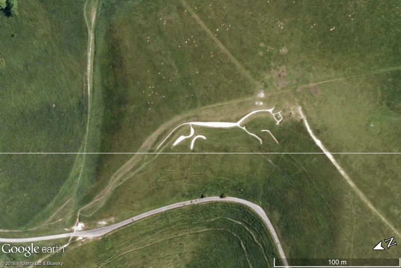
The Uffington White Horse is located on a hillside in Oxfordshire, England. The figure, deeply cut into the soil and filled with chalk, is oriented south, southwest. One theory for why the horse is aligned in this direction is that in midwinter the sun appears to overtake the horse, reflecting a mythological belief that the sun was carried across the sky on a horse or in a chariot. We propose another explanation. If we draw a line between here and Stonehenge, the horse appears to be headed precisely in that direction (Figure 7). Dated to 1380 to 550 BCE, a relatively short time after the completion of the last phase of construction at Stonehenge around 1600 BCE, could the Uffington White Horse have been a directional marker pointing toward Stonehenge?
Top image courtesy Marilyn Bridges.
Discover more from Before Atlantis
Subscribe to get the latest posts sent to your email.

