In this article, we digress from our investigation of ancient mysteries on Earth to examine an unresolved mystery on the moon.
Half a century ago Apollo landed the first men on the moon. A few years later the Soviet Union continued their unmanned exploration program with the landing of the Luna 21/Lunokhod 2 spacecraft in the crater Le Monnier. A month later, on Thursday, February 15, 1973, the Soviet news agency Tass reported that the Lunokhod 2 was investigating “an unusual piece of lunar material.” The report stated that a “one-meter long plate, resembling a modern house panel, has proven to be a strong monolith” and goes on to describe the plate as having “a smooth surface.” An article in the January-February 1973 issue of the ARPO Bulletin contained excerpts from a story in the February 19 issue of Soviet Aerospace:
“The article [in Soviet Aerospace] stated that the ‘stone plate which has so puzzled scientists’ has a smooth surface which is unlike the large stones in the area and that it withstood ‘the buggy’s pressure of a hundred atmospheres’ (1,407 lb. per square inch) which left only slight traces on the thin layer of dust which covered the plate. Also, the article said, scientists have determined that the plate ‘seems much younger’ than other stone material in the area.”
“Because of the monolith’s uniqueness, scientists decided to continue to investigate it to determine its chemical composition and magnetic properties, as well as transmit TV photos. The object was found on February 13 and plans were made to continue the investigation through the 16th. The bedrock in the immediate area was described as being different from the material observed and tested earlier and because the monolith is also so different from the surrounding bedrock the scientists were wondering if such a combination is accidental.”
News of this discovery was also reported by NASA:
“A monolith one meter (three feet) long of unusual lunar material was discovered Feb. 13. The plate had a strong, smooth surface unlike surrounding pockmarked stones and appeared to be much younger.”

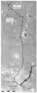
Figure 1 summarizes the first three months of the probe’s operation on the moon. According to Phillip Stooke in the International Atlas of Lunar Exploration
“From 12 to 16 February the rover parked near a large fresh boulder as the high Sun made visibility difficult. The rover then drove rapidly south to the nearby hills where it took new panoramic images and performed experiments.”
This is when, according to both the Tass and Soviet Aerospace stories, the rover was analyzing and taking photos of the monolith. The location of the rover over this period of time is marked in the figure with the label “12-2-73 to 16-2-73 X, P” where “X” and “P” indicate that x-ray fluorescence spectrometer measurements and panoramic photographs were taken, presumably after the rover had left the shade of the boulder and traveled south.
The Laboratory for Comparative Planetology website lists 92 pan photos captured in 44 sessions. The map in Figure 1 plus three other maps depicting the later movement of the rover show 26 locations where photos were taken. Stooke states that the map does not list all of the panoramas. It is also not clear if the website includes all of the photos that were taken.
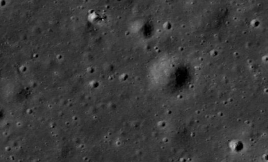
Most of the panoramas show rolling, relatively featureless terrain. Figure 2 shows one of the photos taken during the second month (lunation) of lunar operations. Notice the angular rock in the center of the photo. The length of its shadow indicates the picture was taken late in the day, not around noon, when the rover was said to have been parked next to the large boulder. Other than Figure 2, none of the photos shows anything resembling a slab, let alone a monolith.

If this rock encountered by the Lunokhod rover was so extraordinary why is there no photo of it? Was the announcement by Tass simply propaganda – an attempt to match the accomplishments of the US Apollo program? Or did the Soviets discover something remarkable on the moon, so remarkable that the photos and scientific data were withheld from their own scientists and the international community?
Where on the Moon?
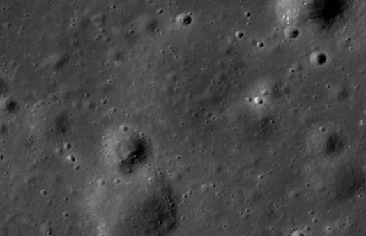
After exhausting the available historical data we have reached a dead end. Still, it might be possible to use this information in conjunction with current imagery to search for the monolith using future probes. The Lunar Reconnaissance Orbiter has imaged numerous manned and unmanned spacecraft on the lunar surface including the Luna 21 lander (Figure 3).

The tracks left by the rover are also visible over much of the terrain, which can be viewed using ASU’s Quickmap viewer. By correlating Figure 1 with LRO imagery we can determine the general area where the rover was parked from February 12-16. An area around 25.87°N 30.45° E is shown in Figure 4. This location, somewhat less than three miles from the landing site, is near several unusual rectangular craters but appears otherwise unremarkable.

Although it is not possible to image an object only a meter long from lunar orbit, it may be possible one day to revisit this area on the moon, now that we know where it is, and rediscover what Lunokhod might have found almost a half-century ago.
The author would like to thank Rick Sterling, Fran Ridge, and Ananda Sirisena for their contributions.
Top image from the move 2001: A Space Odyssey.


One Reply to “”