


The theory that civilization developed in India as the result of the migration of Aryans from the north had to be revised after the discovery of the Indus Valley Civilization in the 1920s. In 1999-2000, a marine archaeological survey found the remains of an ancient civilization beneath the Gulf of Cambay. The similarity of structures submerged for more than 10,000 years to those in Harappa, Mohenjo-daro, and other Indus Valley cities that are thought to have been built in the 3rdmillennium BCE raised the question of whether or not an even earlier civilization once existed in this part of the world.
This article presents new evidence suggesting that certain sites in the Indus Valley and in other parts of India were first established during and possibly even before the last ice age based on their alignments to previous locations of the North Pole.
Click here to read the full paper.
Indus Valley Sites
The Nile and Tigris-Euphrates valleys were once regarded as the birthplace of modern civilization. Excavations of the ancient cities at Harappa and Mohenjo-daro in the 1920s offered the first hint that another equally advanced, contemporaneous civilization once existed in the Indus Valley.
Harappa
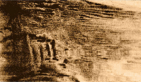
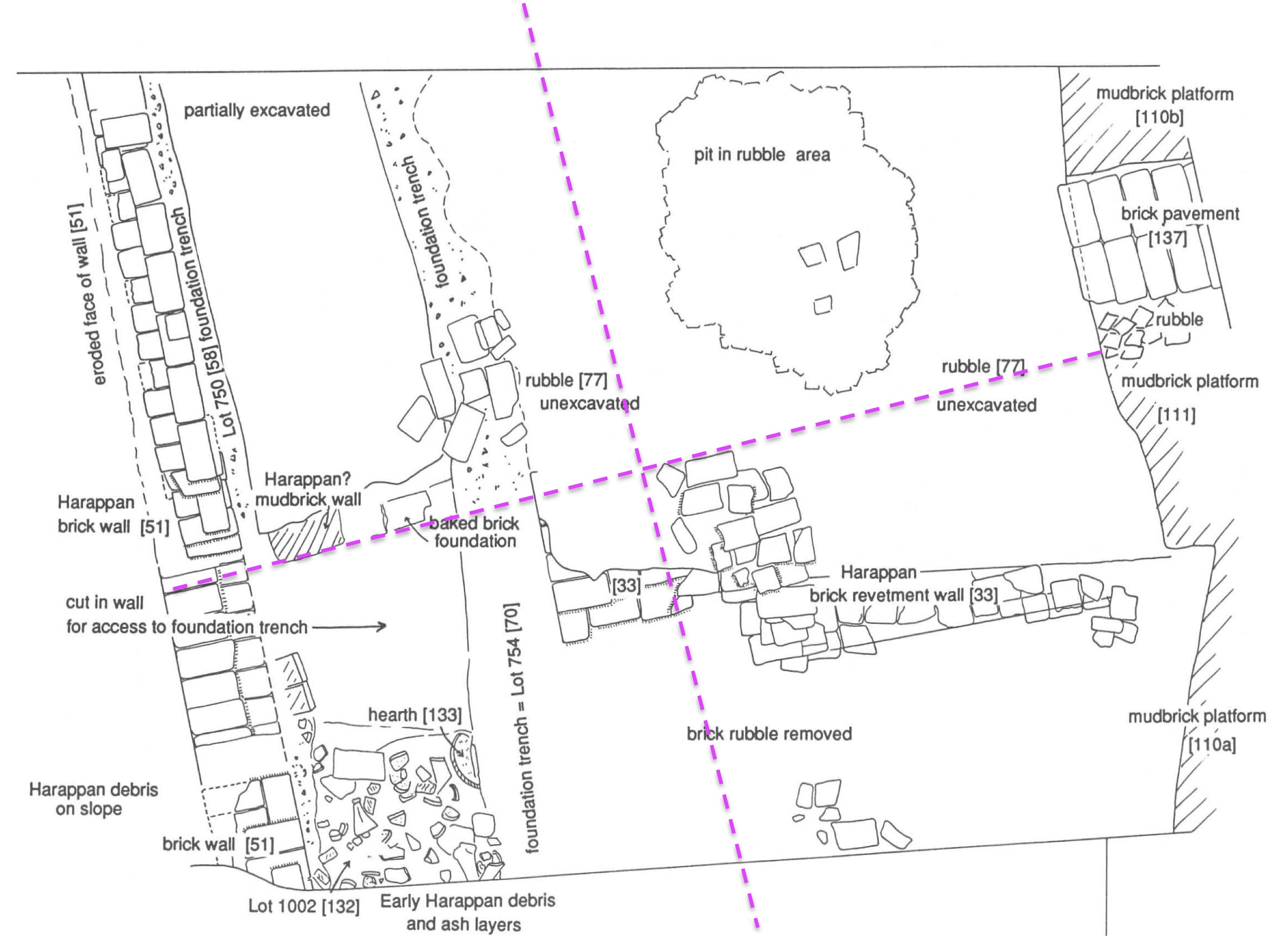
The first excavations at Harappa were led by Daya Ram Sahni who uncovered as many as eight levels of construction within the ancient city. Dales and Kenoyer (1991) describe the lowest levels:
Beneath these latest Harappan structures are earlier mud-brick platforms that overlay a series of eroded and reconstructed platforms. The mud-brick platforms and retaining wall appear to have been strengthened by a baked brick revetment or facing. Traces of this baked brick revetment have been found to the west of the mud-brick revetment wall. This structure was about 2 meters wide at the base, with a sloping exterior face. Based on calculations of toppled courses of brick, it is estimated that this baked brick facing stood some 3 to 4 meters high from natural soil to the crest of the mound…
Wanzke (1984) notes that structures at Harappa are misaligned with respect to the cardinal directions. Detailed drawings (Dales and Kenoyer 1991) show that extended sections of brick walls and platforms within Mound E are rotated approximately 14° west of north. Kak (2010) discusses Harappan (i.e., Indus Valley Civilization) astronomy but does not comment on the alignment of the ancient city itself. As shown below this direction is toward the previous location of the North Pole near Hudson Bay. Based on its alignment to the Hudson Bay pole, Harappa may be as old as the structures beneath the Gulf of Cambay.
Mohenjo-daro
According to Jansen (1984), the goal of the excavations at Mohenjo-Daro was to reach “virgin soil.” He states
Since virgin soil was never reached through vertical diggings the full horizontal extent of the site beyond the mounds visible at present, which were normally regarded as being the outer limits of the former site, remains unknown.
Archaeologists date Harappa, Mohenjo-daro, and other Indus Valley cities to around 2600 BCE. The results of several deep digs at Mohenjo-daro suggest that it could be much older. Drilling reports at what is known as the “old site” found bricks and pottery down as far as 70 feet below the surface. An early report from 1931 stated: “The excavation revealed the existence superimposed one above the other of structural remains belonging to the three latest cities and remains of other structures underneath them.” An attempt in 1950 to find the bottom-most level of the site was unsuccessful. It can be argued that if archaeologists cannot find the bottom-most layer of a site they cannot state with any certainty its age.

Aerial imagery over Mohenjo-daro clearly shows the site is not aligned to the cardinal directions. Wanzke (1984) made detailed measurements of the site that he was unable to explain. The figure above shows the stupa, bath, grainary and other structures atop the acropolis are aligned in solstice directions relative to the Hudson Bay pole. Similar alignments can be found throughout the ancient city. What is particularly interesting is that these alignments are identical to those found at Merv and Gonur Tepe in Central Asia (Carlotto 2020). We thus hypothesize that based on its alignment, Mohenjo-daro like these other places were first established at least 18,000 years ago when the North Pole was in Hudson Bay.

Kalibangan
A significant find at Kalibangan was the discovery of a pre-Harappan (i.e., pre-Indus Valley Civilization) settlement below the remains of the Harappan citadel (Thepar 2015) that is described as follows:
The occupation endured through five structural phases, rising to a height of 1.6 m. above the natural soil, when it was brought to a close by a catastrophe (perhaps seismic), as evidenced by the occurrence of displaced (faulted ?) strata and subsided walls in different parts of the excavated area. Thereafter, the site seems to have been abandoned, though only temporarily, and a thin layer of sand, largely infertile and wind blown, accumulated over the ruins. During this period the peripheral portions of the mound, particularly on the east and west, seem to have been badly eroded and gullied.
Also organized in a grid pattern, Kalibangan, like Harappa, appears to be aligned to the Hudson Bay pole. Thepar estimates the earlier settlement existed perhaps a century or two before the Harappan city. We propose the earlier settlement was built over even older structures that were aligned to the Hudson Bay pole.

Sacred Sites
Dwarka is in the province of Gujarat, south of the Indus Valley. The search for underwater ruins off the coast of India was inspired in the 1960s at Dwarka by the discovery of pottery shards that were once underwater and later buried in the sand for two thousand years. In the cleared remains of a building next to the Dwarkadhish Temple, Rao (1990) discovered three temples built over one another with the oldest dated to the middle of the second millennium BCE. These discoveries led to the realization that Dwarka had been rebuilt many times over as a result of sea-level rise. Thought to be the Dwarka of the Mahabarata the possibility that an even older city lies submerged off the coast of modern-day Dwarka led to a series of expeditions in the 1980s (Gaur et al 2004) including those further south in the Gulf of Cambay (Badrinaryan 2010).
Benaras
According to a famous quote by Mark Twain, “Benaras is older than history, older than tradition, older even than legend and looks twice as old as all of them put together.” Artifacts at several sites in Benaras, also known as Varanasi or Kashi, have been dated to 1800 BCE. Benaras is located in north-central India and like Mohenjo-daro, which is more than 1500 kilometers to the west, the orientation of one of the sites is aligned in solstice directions relative to the Hudson Bay pole. Approximately two miles east of this site is the Shri Kashi Vishwanath Temple. The temple, which is located just west of the Ganges does not face the river but is aligned in the direction of the Hudson Bay pole.
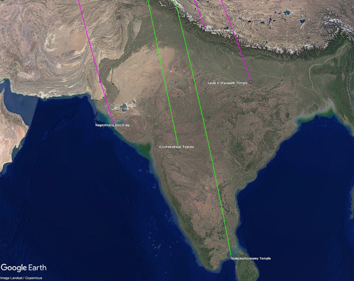
The Twelve Jyotirlinga Temples
The Shri Kashi Vishwanath Temple in Benaras and the Nageshvara Jyotirling Temple in Dwarka are two of twelve Jyotirlinga, which are devotional temples and shrines devoted to Shiva. In examining the alignments of all twelve Jyotirlinga, which are located throughout India, three are aligned to the cardinal directions, one to solstices, and five to previous locations of the North Pole in Hudson Bay and Greenland (see above figure). The Nageshvara Jyotirling is aligned in the same direction as the two other temples in Dwarka discussed above. The alignment of these temples to previous locations of the North Pole suggests the possibility that the original sites were established tens of thousands of years before becoming Hindu temples.

Sanchi Stupas
The Great Stupa at Sanchi in central India is believed to be one of the oldest stone structures in India, built under the rule of Ashoka in the 3rd century BCE. Rao (1992) proposes that the Buddhist stupas of Sanchi including the Great Stupa were oriented towards moonrise and sunset on the day of Buddha Purnima when they are thought to have been built, around 2nd century BCE. Like Mohenjo-daro and Benaras, its alignment to solstices relative to the Hudson Bay pole suggests another possibility – that the original site was first established tens of thousands of years when the North Pole was in Hudson Bay and later co-opted by Ashoka as a sacred site. A similar argument has been proposed to explain the orientation of the Parthenon and other structures atop the Acropolis in Athens relative to the Greenland pole as an alternative to the existing explanation that the Parthenon was aligned in the direction of sunrise on the date of Athena’s birthday (Carlotto 1999b). If Athena’s birthday was established based on the pre-existing alignment of the Acropolis to the Greenland pole then perhaps the date of Buddha Purnima was similarly established based on pre-existing alignments at Sanchi.
Discussion
Without a “rosetta stone” or some other means of translating the Indus script it is far from certain how the Indus Valley civilization began. One theory is that it developed from earlier agricultural societies such as those at Mehrgarh in the 7thmillennium BCE with cities such as Harappa and Mohenjo-daro established much later during the 3rdmillennium BCE.
Another theory is that the Indus Valley was once a part of a larger and older civilization. This theory is supported by Badrinaryan’s discovery of ruins off the coast of Gujarat in western India in the late 1990s. According to Badrinaryan “Most of the structures that were discovered in the Gulf of Cambay had many similarities to the CITADEL, GREAT BATH and grid-iron pattern habitation sites, grannery, etc. of the Harappan civilization.”
Considering Badrinaryan’s discoveries, Robinson (2018) argues that it may be time to revise history once again:
Is this lost city the stuff of legends and myth? Badrinaryan’s discovered city feels similar to the lost city of Troy before Heinrich Schliemann found it in the 1870s.
Based on their location and depth, the ruins below the Gulf of Cambay must be at least 10,000 years old. Thermoluminescence dating of pottery shards recovered at several locations in the gulf revealed even more ancient dates, some as old as 31270±2050 years BP, more than 10,000 years before the last glacial maximum.
Evidence of widespread trading with neighboring regions including Mesopotamia and Central Asia (Bactria–Margiana Archaeological Complex) suggests the Indus Valley was at one time part of a larger civilization in this part of the world. According to Bakry (2006):
Due to the big amount of Indian or Indian related objects discovered in Central Asian sites (more than Central Asian in India), one can say that the Indus people were the initiators for these relations at their initial stage, or the direction of relations was more from India to Central Asia. Later on, after the formation of BMAC in Central Asia, such relations took direction more from Central Asia to India. This happened especially when Harappan civilization started to decay in the beginning of the second Mill. BC, as if BMAC peoples sensed a vacuum in the Indus Valley region and moved in to fill it.
We propose that the Indus Valley Civilization and the BMAC were the descendants of an even earlier civilization. Badrinaryan (2010) sums it up:
So, from the foregoing it is very evident the prehistoric civilization that matured and developed in the present day Gulf of Cambay was the forerunner and model to the subsequent advanced Harrapan civilization known to history. This wonderful twin prehistoric metropolis of Cambay lasted from about 13000 BP to about 3000 BP making it the most ancient and largest city civilization not only in Asia but in the entire world. It is seen to be at least 7500 years older than the oldest Mesopotamian city civilization. However strong evidence supports the presence of humans from at least 31000 BP who were evolving and developing and formed a great hitherto unknown civilization that were submerged by the flood, giving credence to local and global flood myths.
The alignment of numerous archaeological sites in this part of the world to previous locations of the North Pole supports Badrinaryan’s discoveries in the Gulf of Cambay. In his opinion, the sudden appearance of a technically advanced civilization in this part of the world suggested that there was a “missing link between the ancient hunter gatherer group of people and ‘Harappan’ civilization. In India, there were many Paleolithic, Mesolithic and Neolithic stone-age cultures. But none of them have any remote resemblance of the type of civilization found in the Harappan sites.” He goes on to suggest that
It is possible that the missing link between the two is either under cover or has been submerged due to major sea level rise caused by melting of ice-sheets.
Perhaps it is both. Complementing Badrinaryan’s discoveries under the Gulf of Cambay we believe that the alignments of Indus Valley and other sites in India to previous locations of the North Pole is the other half of this missing link that together can lead to a better understanding of the origin of early civilizations in this part of the world.
References
Charles H. Hapgood (1958) Earth’s Shifting Crust: A Key to Some Basic Problems of Earth Science, Pantheon Books.
K. Thapar (1979) “Kalibangan: A Harappan Metropolis beyond the Indus Valley,” in Ancient Cities of the Indus (Gregory L. Possehl, ed.), Vikas Publishing House.
Arthur Cotterell (1980) “The Indus Civilization,” in The Penguin Encyclopedia of Ancient Civilizations (Arthur Cotterell, ed.), Penguin Books.
Jansen (1984) “Preliminary results on the ‘forma urbis’ research at Mohenjo-Daro,” In Interim Reports on Fieldwork Carried out at Mohenjo-daro 1982-83, Vol. 2, (M. Jansen and G. Urban, eds.).
Wanzke (1984) “Axis systems and orientation at Mohenjo-Daro,” ibid.
R. Rao (1990) “Excavation of the legendary city of Dvaraka in the Arabian Sea,” Marine Archaeology, Vol. 1: 59-98.
George F. Dales and Jonathan Mark Kenoyer (1991) “Summaries of Five Seasons of Research at Harappa (District Sahiwal, Punjab, Pakistan), 1986-1990” in Harappa Excavations 1986-1990 – A Multidisciplinary Approach to Third Millennium Urbanism (Richard H. Meadow ed.)
Kameswara Rao (1992) “History of Astronomy – Astronomy with Buddhist stupas of Sanchi,” Bull. Astr. Soc. India, Vol. 20:87-98.
S. Gaur, Sundaresh and Sila Tripati (2004) “An ancient harbour at Dwarka: Study based on the recent underwater explorations,” Current Science, Vol. 86, No. 9.
Badrinaryan (2010) “Gulf of Cambay Cradle of Ancient Civilization,” in Lost Knowledge of the Ancients (Glenn Kreisberg, ed.)
Subhash Kak (2010) “Visions of the Cosmos: Archaeoastronomy in Ancient India,” Journal of Cosmology, Vol. 9: 2063-2077.
Bakry (2016) “Prehistoric Contacts between Central Asia and India,” Transactions of Margiana Archaeological Expedition, Vol. 6:422-565, Moscow.
Marsha R. Robinson (2018) Disobedient Histories in Ancient and Modern Times: Regionalism, Governance, War and Peace, Cambridge Scholars Publishing.
Carlotto, M. J. (2019a). “Archaeological dating using a data fusion approach,” Signal Processing, Sensor/Information Fusion, and Target Recognition XXVIII, Baltimore MD.
Mark Carlotto (2019b) “New Models to Explain the Alignments of Greek Temples,” https://dx.doi.org/10.2139/ssrn.3501950.
Mark Carlotto (2020) “Ruins in the ‘Stans: Evidence of a Lost Civilization in Central Asia,” Available at SSRN: http://dx.doi.org/10.2139/ssrn.3677452.\
Acknowledgement
Discover more from Before Atlantis
Subscribe to get the latest posts sent to your email.


An outstanding share! I have just forwarded this onto a coworker who was conducting a little homework on this. And he actually bought me lunch because I discovered it for him… lol. So allow me to reword this…. Thank YOU for the meal!! But yeah, thanx for spending the time to discuss this issue here on your blog.
LikeLike