


Before Atlantis introduces the idea that many ancient sites throughout the world might be far older than previously thought based on the alignment of these sites to previous locations of the North Pole. This article discusses one of the sites, Machu Picchu, in greater detail.
Introduction
Unlike so many other places that were destroyed by the Spanish, Machu Picchu remained unknown to the outside world until its rediscovery by Hiram Bingham in 1911. Most archaeologists believe Machu Picchu was built by the Incas for their emperor Pachacuti in the fifteenth century; however, no one has been able to adequately explain all of the structures at the site in terms of technology that is thought to have been available to the Incas at that time.

For the purpose of understanding the layout and orientation of the site, Giulio Magli divides Machu Picchu into four sectors (Figure 1). Sectors I and II occupy the southeast and northeast portions of the site consisting of numerous compounds called kanchas. The kanchas at Machu Picchu contain structures constructed from coarsely fitted stones that conform to the terrain and are oriented in generally eastern facing directions. Magli sites evidence that the Incas could have conducted accurate celestial observations related to the solstices within these two sectors.
Skipping Sector III for the moment, Sector IV contains the enigmatic Temple of the Three Windows and the Intihuatana. In contrast with the kanchas, the structures in Sector IV consist of much more massive and precisely cut and fitted stones. Archaeologists believe that the structures in Sector IV were constructed last and left unfinished by the Incas. Another possibility is that the structures in this part of the site are the ruins of something that is much older, constructed by an earlier pre-Inca civilization. Is there any evidence of an earlier civilization at Machu Picchu?
Temple of the Three Windows
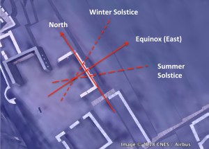
Sector III is an open northwest facing area that Magli associates with a range of directions between 135° to 155° (or -55° to -25°) that are thought to have been important to the Incas. Too far south of east to be aligned to the Sun or Moon, Magli suggests that this range of orientations might reference certain celestial features such as the Milky Way – the celestial counterpart of the Vilcanota river, which could have been used to determine the timing of the equinox based on its relation to the Sun. This direction also turns out to point to a possible pole in the Bering Sea 80,000 to 85,000 years ago or more. Could this direction have been important to the Incas simply because it was once north?

That this direction once pointed north seems consistent with the alignment of the Temple of the Three Windows (Figure 2). The orientation of the eastern wall, -34° (or 34° west of north) is aligned to within a few degrees of the Bering Sea pole. This means that if the North Pole were in the Bering Sea, the three windows would have faced due east and the Sun would have risen in line with the temple on the equinox (Figure 3).

Intihuatana
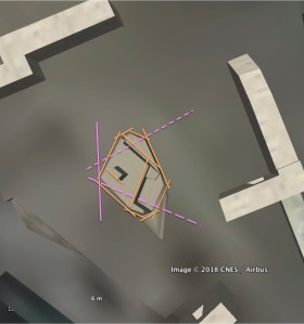
It has been suggested that the Intihuatana (Figure 4) or “hitching post of the Sun,” a name attributed to Bingham, was designed to mark dates when the Sun would be directly above the Intihuatana and so would cast no shadow. A simple gnomon with a vertical shaft casts no shadow at noon on the equinox only if it is at the equator (Figure 5) Since Machu Picchu is about 13° south of the equator the device must be tilted in the direction of the Sun for it to disappear on a given date (Figure 6). For example, if it is intended to mark the date of the summer solstice, it must be tilted in the direction of the sun on that date by approximately 11°; if it is intended to mark the date of the equinox, it must be tilted due east by approximately 13°.


If the function of the Intihuatana is just to mark the days when the shadow of the sun disappears why is its shape so complex?

Before the Bering Sea to Norway Sea pole shift, Machu Picchu would have been rotated approximately 34° counterclockwise (i.e., west of north) relative to its current orientation and shifted about 6° further south in latitude. Figure 7 is a 3D model of the Intrihuatana with alignments relative to the Bering Sea pole. Being even further south than it is now, the surface would have to have been tilted even further toward the east for the Sun to disappear on the equinox. Although some sides and edges of the Intihuatana stone appear to be somewhat aligned to the pole and the winter solstice sunrise directions, its shape seems inconsistent with that of a device designed to mark either solstices or the equinox at this time.

After the pole shift, the Temple of the Three Windows would no longer face east. A new way might have been required to mark the cardinal or other important directions at Machu Picchu. It is hypothesized that several versions of the Intihuatana were constructed over time. The original device could have been constructed after the Bering Sea to Norway Sea pole shift (Figure 8) at which time the gnomon and several sides appear to closely reference the directions of the pole and the summer solstice. Was the original Intihuatana created at the time when the North Pole was in the Norway Sea to mark the summer solstice?

A later pole shift from the Norway Sea to Greenland would rotate Machu Picchu to within a few degrees of its current orientation and shift its position to within 2° of the equator (Figure 9). At this point, the original device was no longer aligned to the summer solstice, but with a vertically oriented gnomon would have been virtually shadowless at noon on the equinox. Perhaps it is at this point in time that the device serendipitously became the “hitching post” of the Sun.
After the next pole shift from Greenland to Hudson Bay, Machu Picchu shifted south several degrees and rotated clockwise several degrees. It is possible that the Intihuatana could have been modified to once again be an equinoctial marker by adjusting its inclination slightly to account for its new latitude and alignment to north.
Figure 11 summarizes possible alterations to the shape of the Intihuatana stone based on its past alignment to ancient poles and corresponding solar directions. Could the complex and otherwise inexplicable shape of the Intihuatana be the result of numerous incremental changes that had to be made to the device, originally designed as a solsticial marker, for it to continue to function later as an equinoctial marker?

Summary
Application of Charles Hapgood’s hypothesis that the Earth poles have shifted several times over the past 100,000 years provides new insights into many ancient sites that have defied conventional explanation. Our analysis suggests that the Temple of the Three Windows might be one of the oldest structures at Machu Picchu, and that the Intihuatana, constructed sometime later could have functioned first as a solsticial marker and later as an equinoctial marker over most, if not all, of its long history.
Featured photo credit: pululante, Machu Picchu, Peru-21Sept2013 (18), CC BY 2.0
Discover more from Before Atlantis
Subscribe to get the latest posts sent to your email.


.jpg)