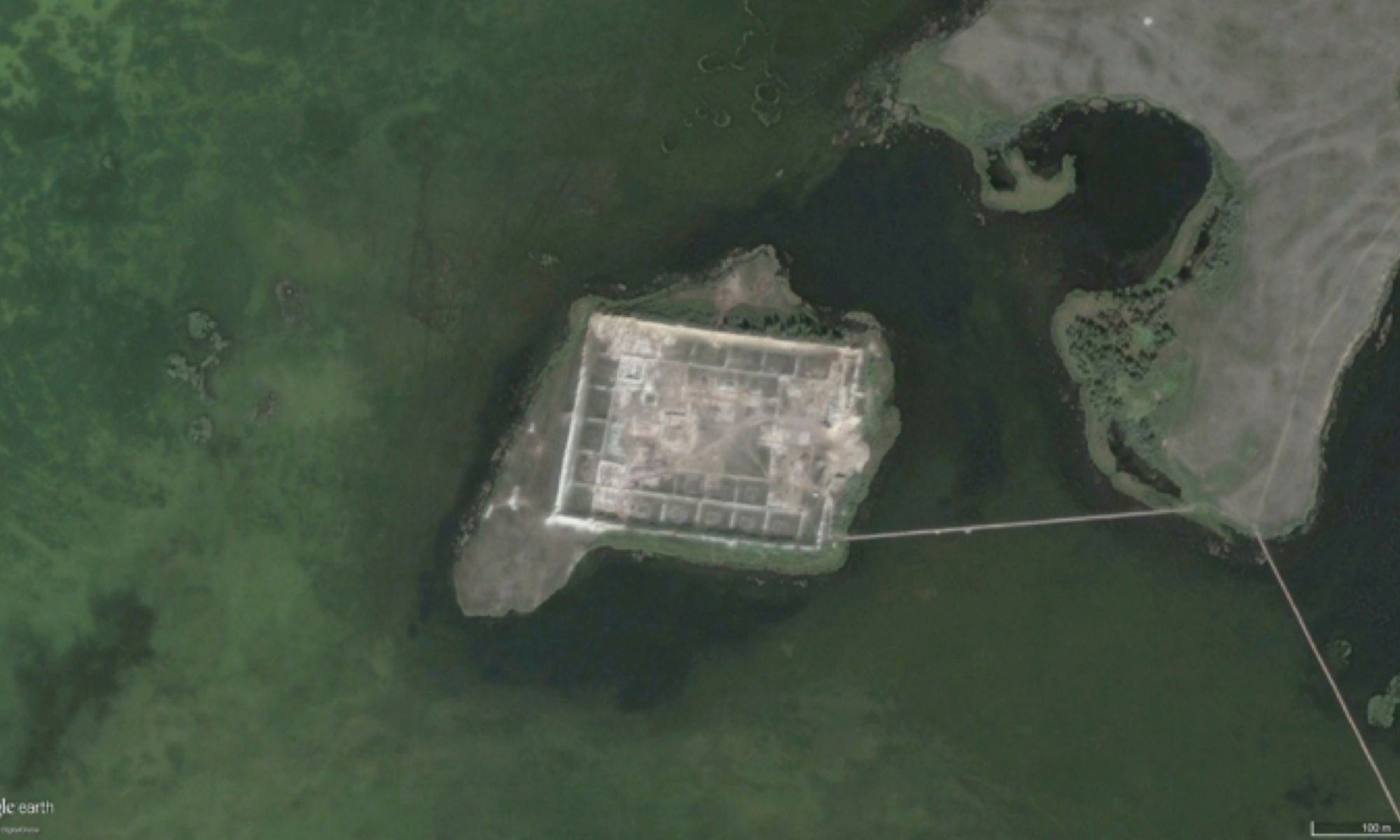
Por-Bajin is a remote archaeological site located in the mountains of southern Siberia. The walls of the site, which resemble a fortress, are massive – up to 10 meters tall and 12 meters thick at the base – enclosing an area of about seven acres containing the remains of dozens of buildings. Constructed from clay supported by wooden beams, the buildings within the site are thought to have been built around 780 CE by a nomadic people known as the Uighurs.
What is particularly unusual about the site is that it is located on an island in the middle of a shallow lake almost literally in the middle of nowhere. If it were a fort, a shallow lake would offer little protection. Adding to the mystery is a lack of artifacts and evidence of sustained occupation. Perhaps this should come as no surprise as the ground beneath the buildings is permafrost and the buildings had no apparent heating system. Archeologists admit that after two years of intensive fieldwork, with one-third of the site excavated, Por-Bajin remains a mystery.
Although the site is said to be oriented east-west, Por-Bajin is, in fact, rotated 7.5 degrees east of north. Can its orientation offer any clues about when it was built, and by whom?

Chinese Influence
In China, there are numerous earthen pyramids that were constructed as mausoleums and burial mounds containing the remains of early emperors and their families. Some of these pyramids are oriented to the cardinal directions, but some are not. Historically, the art of placing, arranging, and orienting cities, streets, palaces, houses, and tombs, known as divination, geomancy, or Feng shui, has been an important element in Chinese landscape design and city planning.
Researchers from the Czech Republic have shown that there is a correlation between the orientation of many Chinese pyramids and the location of the magnetic pole at the time they were built. The magnetic pole wanders slowly over time. By using a model of the past motion of the magnetic pole and knowing the approximate construction date of the site, the Czech study shows that some form of magnetic compass, which was known to the Chinese as early as the fourth century BCE, could have been used to align the pyramids to magnetic north.
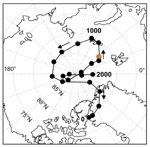
Archaeologists have noticed that the architecture and construction methods at Por-Bajin are similar to those in China at the time. Did the builders of Por-Bajin use a compass to align the site to magnetic north? At the time of construction in 780 CE, the north magnetic pole was located near 83°N 40°E (Figure 2). A compass reading at Por-Bajin would have pointed 10° west of north, about 17.5° west of the site’s alignment to north. It is thus highly unlikely that a compass was used to align the site since it would have pointed in the wrong direction.
Past Celestial Alignment
Does the azimuth angle of the site, 97.5°, coincide with solar or lunar events such as solstices or lunar standstills? Table 1 lists sunrise azimuths at the summer and winter solstices and moonrise azimuths at the major and minor lunar standstills at Earth’s minimum and maximum obliquity angles. Clearly, the site is not rotated enough to the east to line up to any of these events.
Was Por-Bajin aligned to a previous location of the North Pole? The Hudson Bay, Greenland, Norway Sea, and Bering Sea poles are located at azimuth angles −2.4°, −4.4°, −28.2°, and 47.9°, respectively. Again, the answer is no.
There is one last possibility – that Por-Bajin could have been aligned to solar or lunar events referenced to earlier positions of the pole.
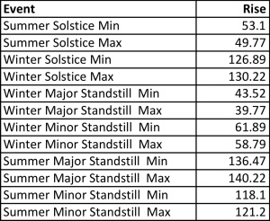
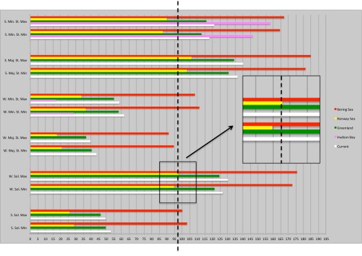
Figure 3 compares the alignment angle of the site to summer and winter solstices and major and minor lunar standstills in summer and winter at minimum and maximum obliquity angles for the current pole (white), Hudson Bay pole (magenta), Greenland pole (green), Norway Sea pole (yellow), and Bering Sea pole (red). For an alignment to have been possible it must lie between the minimum and maximum obliquity values. Comparing the orientation of Por-Bajin to these alignments we find that it would have lined up with the winter solstice sunrise if the pole were located in the Norway Sea.
The Norway pole is −28.2° or 28.2° west of the current North Pole. The site would have been aligned at an azimuth angle of 28.2° + 97.5° = 125.7°, which is within 0.3° of the winter sunrise/summer sunset solstice angle of 126° at the latitude of the site when the pole was in the Norway Sea and Earth was at maximum obliquity (Figure 4).
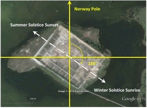
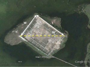
Notice that the diagonal of the site is aligned due east-west. This means that the solstice angle relative to east, 126° −90° = 36°, is also encoded in the aspect ratio of the site’s bounding rectangle; i.e., W/L = tan 36°.
As shown in Figure 3 Por-Bajin would have aligned to the solstice when Earth’s obliquity was close to its maximum value of 24.2°, which occurred 9,000 years ago and reoccurs every 41,000 years. Using a modified version of Charles Hapgood’s original pole shift timeline places the North Pole in the Norway Sea 75,000 to 125,000 years ago. During this period of time, the site would have lined up to the solstice 9,000 + 2 x 41,0000 = 91,000 years ago.
What is particularly intriguing about this date is that at this time, near the end of the Sangamon interglacial period, this part of the world would have been warmer, making the existence of Por-Bajin here in central Siberia much more plausible than it is today. The only problem with this dating is that according to accepted genetic timelines modern humans had not yet left Africa.
A Denisovan Connection?
Evidence of Denisovans – a long extinct humanoid species who coexisted with the Neanderthals about a half-million years ago – was first discovered in a cave located about 900 km west of Por-Bajin. Archaeologists there have mapped out 22 layers of sediment. The earliest evidence of occupation is in the deepest layer (1) going back 282,000 years. In 2008 a stone bracelet was found in layer 11 that has been dated to about 70,000 years ago. The bracelet shows evidence of manufacturing technology typical of much later periods, including a hole made with what appears to have been a high-speed drill.
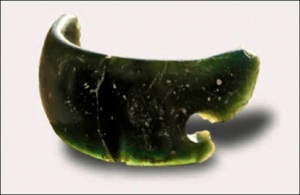
Given the apparent fine-scale technological sophistication of the Denisovans 70,000 years ago, and evidence suggesting that they inhabited this part of the world on and off for 200,000 years or more, could they have built larger structures during this period of time? Pushing the limits of what we know, given the Denisovans possessed an appreciation for jewelry and art perhaps they lived in other places besides caves.
Earlier we wondered how and why a nomadic people built an enormous site on an island in the middle of a lake in such a harsh climate. Perhaps they did not. Could places like Por-Bajin have been first established by Denisovans that were co-opted by later civilizations, the last being the Uighurs? Perhaps deeper excavations at Por-Bajin and other nearby archaeological sites might reveal the true origin of these sites.
Finally, one has to wonder if the Russian government’s interest in Por-Bajin, including its support of the excavation with paramilitary troops starting 2007, had anything to do with the discoveries being made in the nearby Denisova Cave at around the same time. Do they suspect, or have they already discovered a Denisovan connection between these two sites?
Finding evidence of Denisovans at Por-Bajin would support the hypothesis proposed in Before Atlantis that the site was not built by modern humans in historical times but by an earlier indigenous technological civilization in the distant past.



One Reply to “”