


An investigation of astronomical orientations at Göbekli Tepe and other ancient Anatolian sites explores the hypothesis that a significant number of early structures were intentionally aligned to lunar standstills. We find that of 54 pillars at Göbekli Tepe, 9 are oriented approximately east–west (equinox), 4 toward minor lunar standstills, and 10 toward major lunar standstills. The probabilities that these alignments occurred by chance are extremely small, implying intentional design. Extending the analysis to more than 300 sites across Anatolia, we identify 34 additional examples of astronomical alignment toward the equinoxes, solstices, and both major and minor lunar standstills, distributed across multiple civilizations from the late Neolithic to the Roman period. A comparative study of luni-solar orientations worldwide shows that lunar alignments occur more frequently than solar ones, suggesting that knowledge of the Moon’s 18.6-year Metonic cycle was more widespread and ancient than previously recognized. Approximately 90% of the sites examined are unexplained within a fixed geographic pole reference frame. Applying Hapgood’s theory of Earth crustal displacement, we show that alignments at Adada, Selge, Hattusa, Termessos, and other sites are consistent with lunar standstills and solstices relative to former pole locations. Our findings suggest a continuity of astronomical orientation practices extending from the late Pleistocene into historical times and support the possibility that cultural knowledge of celestial cycles predates the Neolithic Revolution. Interpreted within Furter’s model of static human behavioral archetypes, these results imply that the alignment of sacred and monumental architecture to the Sun and Moon may reflect a universal and enduring aspect of human cognition rather than a localized or time-dependent innovation. By incorporating crustal displacement as a working hypothesis, the study provides a quantitative and potentially unifying framework for understanding global patterns of ancient site orientation within a broader geophysical and anthropological context.
Göbekli Tepe and the Moon
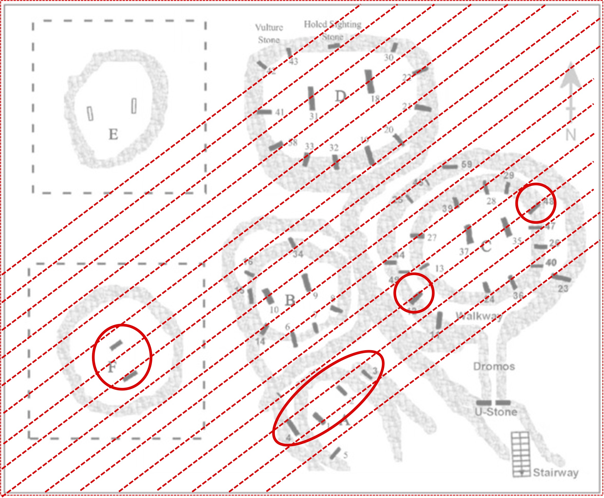
Excavations at Göbekli Tepe revealed the existence of monumental, circular enclosures built from massive T-shaped stone pillars. Believed to be the world’s oldest known temple, the site is dated to a period in human prehistory known as the Neolithic Transition, when our nomadic hunter-gatherer ancestors began to lead a more settled lifestyle, growing crops, building permanent settlements, and developing new technologies like pottery.
Analysis of the six enclosures at Göbekli Tepe reveals several possible astronomical alignments De Lorenzis and Orofino show that four of the enclosures (B, C, D, and E) are oriented towards the setting of the star Deneb, enclosure F is aligned to the rising of the Sun on a day roughly halfway between the summer solstice and the autumn equinox, and enclosure A is aligned to lunar standstills.


Lunar Standstills
Most people have a basic understanding of the motion of the Sun – that it rises in the east and sets in the west. In the Northern Hemisphere, the most northernly sunrise and sunset occur on the summer solstice and the most southernly sunrise and sunset occur on the winter solstice. The situation is reversed in the Southern Hemisphere. Generally speaking, the Moon does in a month what the Sun does in a year. The Moon’s orbital plane tilts up to about 5.1 degrees above and below the ecliptic plane over an 18.6-year cycle. This together with changes in obliquity affect the angle at which the Moon rises and sets. The northernmost moonrise/moonset is called a major lunar standstill. The southernmost moonrise/moonset is called a minor lunar standstill. The most recent major lunar standstill occurred in 2024-2025 and the most recent minor lunar standstill occurred in 2016.

Lunar Alignments in Anatolia
There is a long history of settlement in Anatolia from the late Neolithic to the Roman and Byzantine period. Four of the site established by these civilizations that are aligned to minor lunar standstills are shown below.
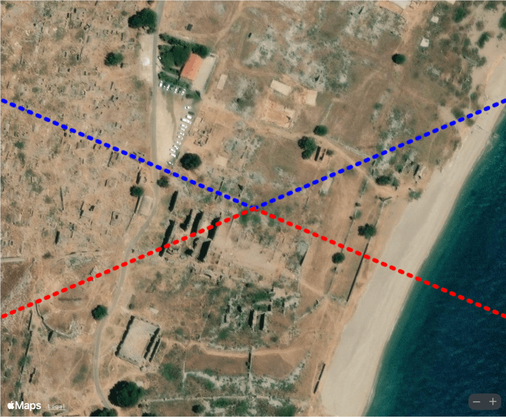
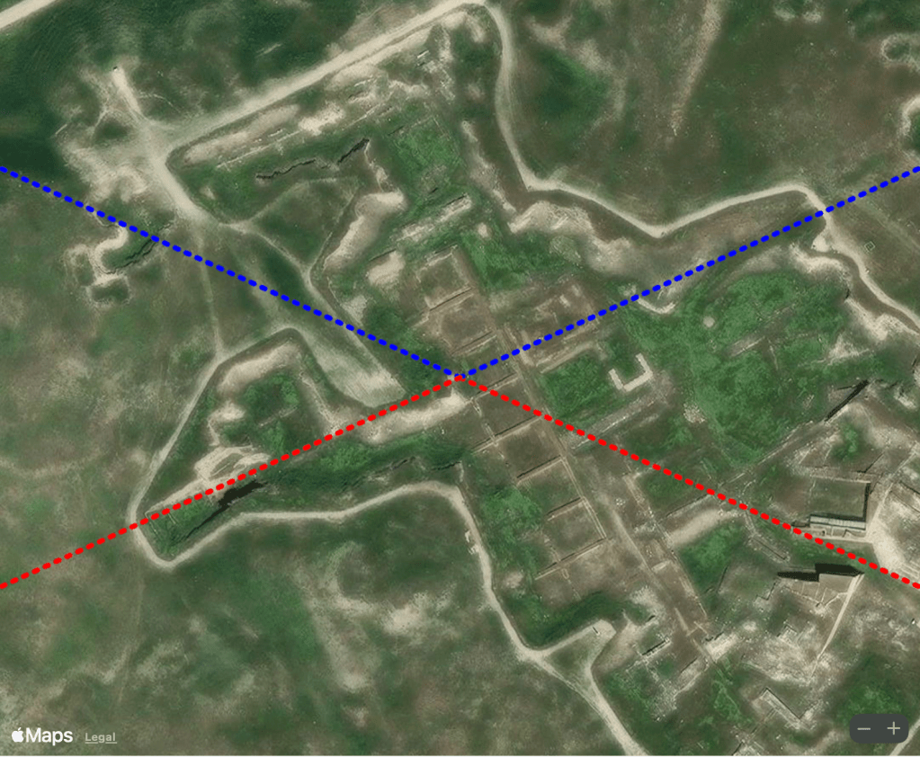
Alignments to minor lunar standstills at Anemourion (top left), Sagalassos (top right), Arslantepe (bottom left) and Gordion (bottom right). (Apple Maps)
Evidence of Lost Civilizations in Anatolia
Hundreds of sites worldwide have been found that reference four previous locations of the geographic poles over the past 120,000 years (Carlotto 2022a). We have argued that Charles Hapgood’s theory of Earth crustal displacement provides an alternative explanation for unexplained archaeological site alignments, late Pleistocene climate changes, and certain mass extinction events and have used crustal displacement as a tentative/hypothetical theory to explore the possibility of previous civilizations during the last ice age. Using this method, we examined the other 90% unexplained sites and found 14 sites containing structures oriented in luni-solar directions relative to previous locations of the North Pole. Four of these sites are examined below.
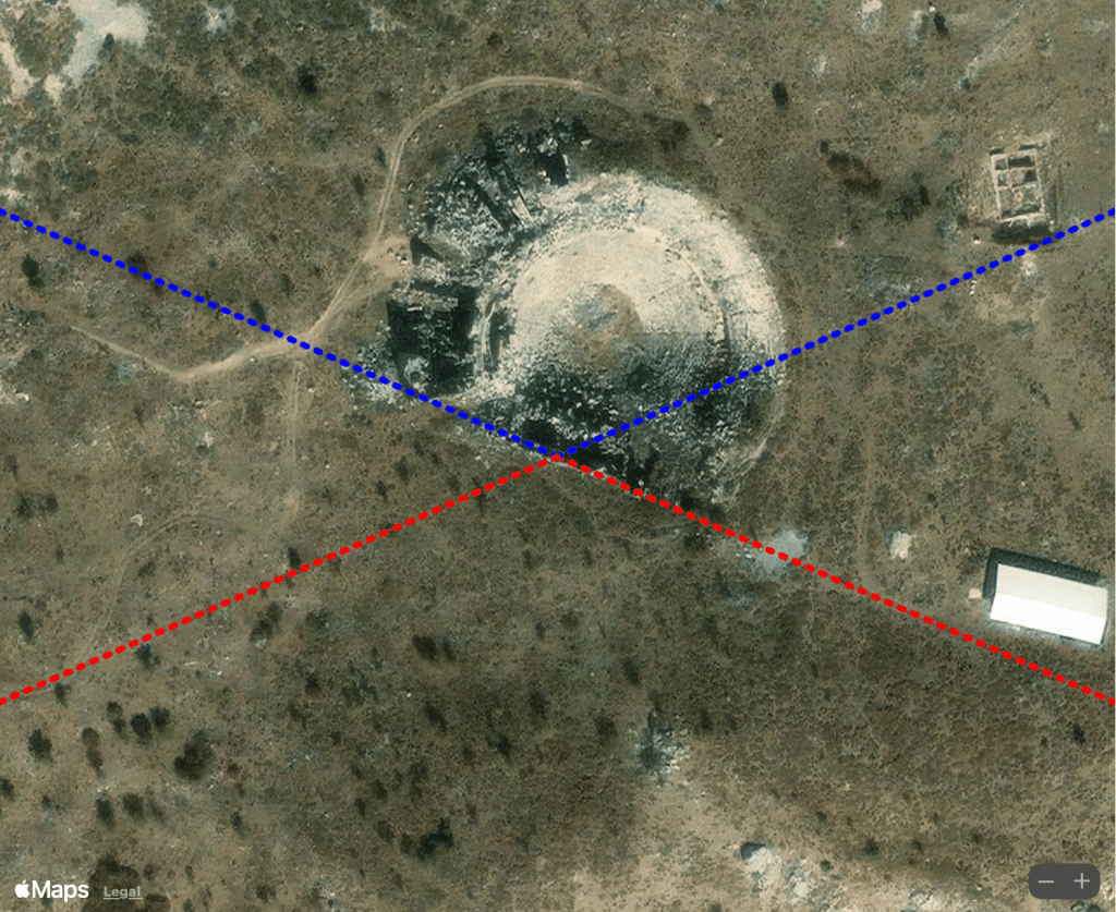
Adada
Like Sagalassos, Adada was one of the ancient cities of Pisidia mentioned by the Greek historian Strabo (Book XII, Chapter 7):
Artemidorus says that the cities of the Pisidians are Selgê, Sagalassus, Petnelissus, Adada, Tymbriada, Cremna, Pityassus, Amblada, Anabura, Sinda, Aarassus, Tarbassus, and Termessus. Of these, some are entirely in the mountains, while others extend even as far as the foot-hills on either side…
However, unlike Sagalassos, Adada does not appear to have been aligned to the Moon or in any other known astronomical direction. However, shifting the frame of reference to the Norwegian Sea pole, the main complex at Adada lines up in the direction of minor lunar standstills relative to the earlier pole as shown above. A smaller structure to the north is oriented in the direction of solstices relative to the Norwegian Sea pole.

Adada was a prosperous Roman city from the 1st century BCE through the 3rd century CE, flourishing particularly during the reigns of Emperors Trajan, Hadrian, and Antoninus Pius, as evidenced by the well-preserved temple complexes dedicated to the emperors and the city’s imperial coinage (right). The orientation of Adada in the direction of minor lunar standstills relative to the Norwegian Sea pole (left) suggests the possibility that it was built on top of pre-existing foundations that could be more than 42,000 years old. (Hasan Karabay/Google Earth and Apple Maps)
Selge
According to Strabo, Selge was founded by the Greek city-state Sparta, but alludes an even earlier founding by the mythical figure Calchas. The amphitheater, which was rebuilt by the Romans in the 3rd century CE is aligned to minor lunar standstills. The acropolis of Selge to the west of the theater known as Cesbedium is mentioned by Polybius in a battle with the Seleucid general, Achaeus. What is particularly interesting is that much of the site, which is ruins, appears to be organized differently. Those atop the acropolis appear to be aligned in the direction of solstices relative to the Greenland pole, as are several other ruined structures to the south (see above). There is also evidence of alignments to major lunar standstills relative to the Greenland pole, and to the Greenland pole itself, all of which support the possibility of an even earlier city founded in myth.
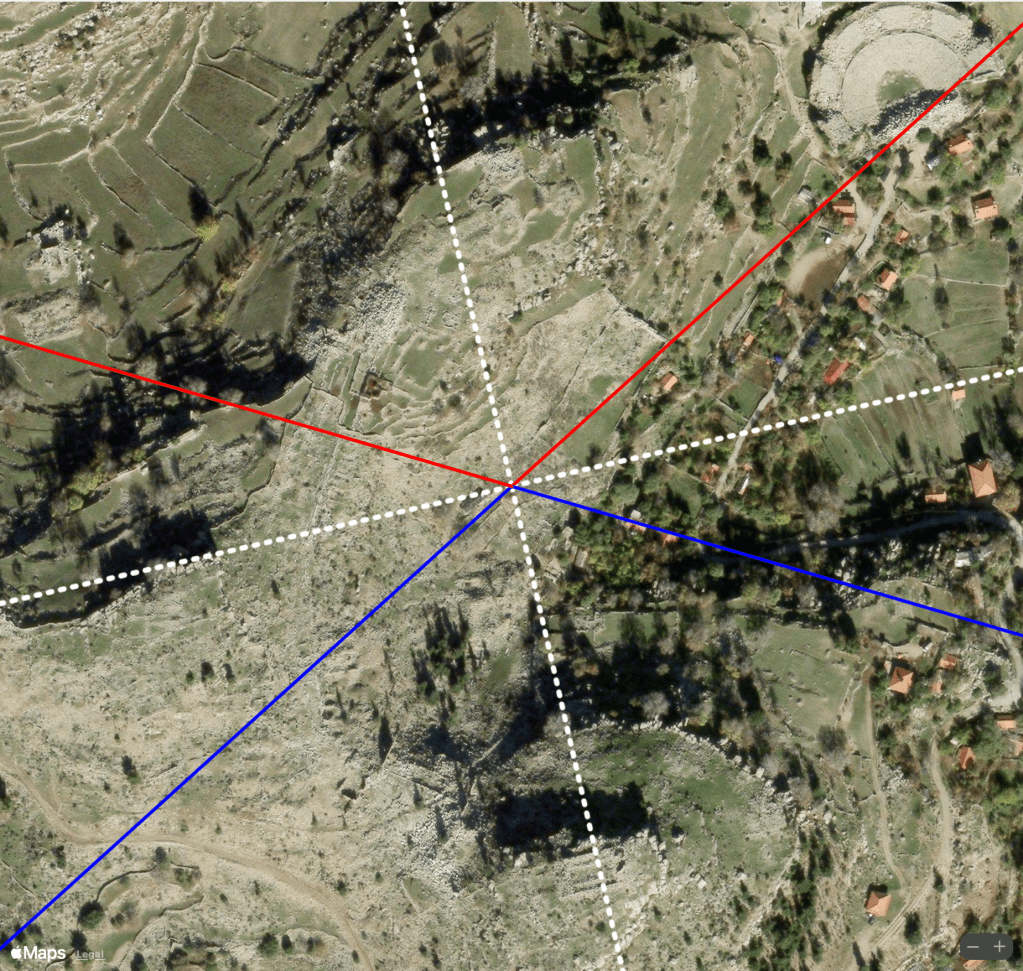
View of the acropolis at Selge from east of the amphitheater (left). Although the amphitheater, which is closely aligned to minor standstills relative to the current pole was built by the Roman, ruins to the south and west (right) appear to be aligned to the Greenland pole (white dotted line) and to solstices relative to the Greenland pole (red/blue). (Dosseman/Creative Commons and Apple Maps)
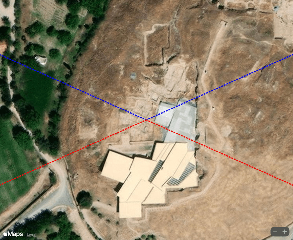
Hattusa
The earliest traces of Hattusa are from the sixth millennium BC during the Chalcolithic (Copper Age) period. The complex contains numerous features aligned in a variety of ways. The orientation of the King’s Gate on the east side of the site is closely aligned to minor lunar standstills. The Lion’s Gate, on the west side, is closely aligned to minor lunar standstills relative to the previous pole in Hudson Bay. Other structures within the site appear to reference both the current and previous pole. The mysterious Green Nephrite Stone within the Great Temple complex is aligned to solstices relative to the Hudson Bay pole.
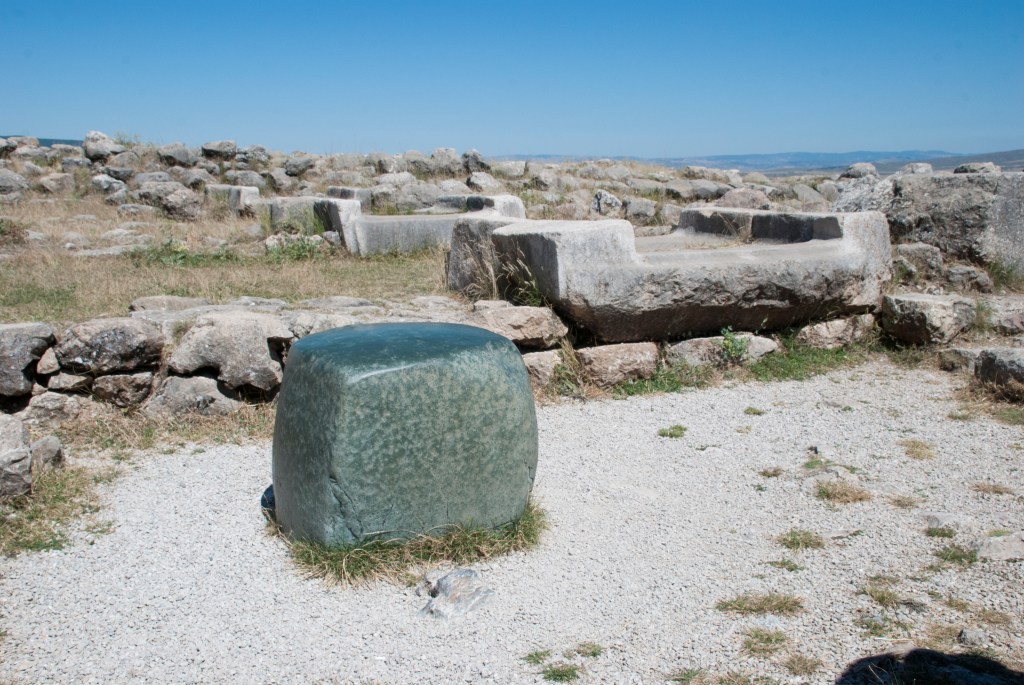
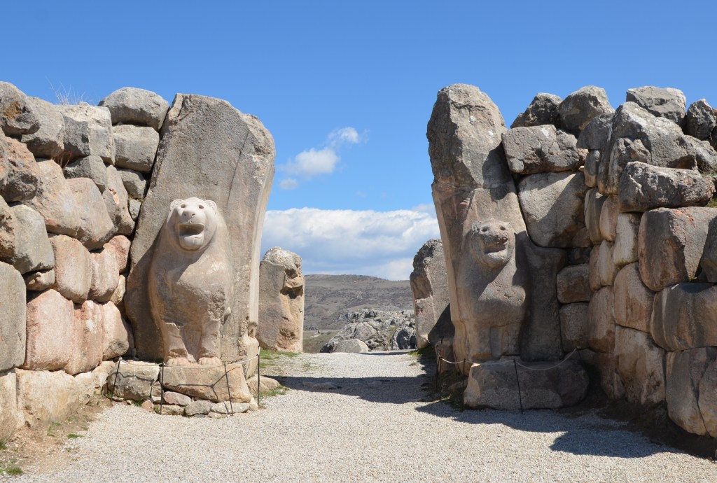


Lion Gate at Hattusa (top right) is aligned in the direction of minor lunar standstills relative to the Hudson Bay pole (bottom right). Green Nephrite Stone at Hattusa and surrounding structures (top left) are aligned in the direction of the summer solstice sunrise and winter solstice sunset relative to the Hudson Bay pole (bottom left). (Acar54/Creative Commons, Carole Raddato/Creative Commons and Apple Maps
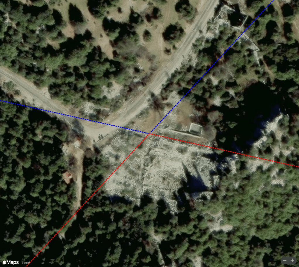
Termessos
Termessos, which is one of the best-preserved ancient cities in Turkey, is linked to the Solymi people, who are mentioned in Homer’s Iliad in relation to the legend of Bellerophon. Termessos was founded by the Solymi, a tribe likely related to the peoples of Isauria and Cilicia. The city’s name, according to Strabo, is derived from the Anatolian god Solymeus, later identified with Zeus. One of the most intriguing aspects is that Alexander the Great failed to conquer Termessos in 333 BC, despite his extensive campaigns. The city’s location on a high mountain, combined with its strong natural defenses, made it nearly impossible to breach. The city was eventually abandoned, likely due to an earthquake that destroyed its essential water supply. The specifics of the disaster and the full timeline of the city’s abandonment remain subjects of mystery. Despite its importance, the site has seen limited excavation, leaving many questions about the city’s history and daily life unanswered.
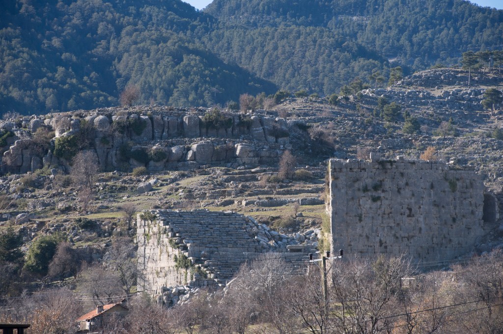
The most distinctive feature is the amphitheater built in the Hellenistic period, showcasing Greek architectural styles. Later, the theater was rebuilt by the Romans. Unlike similar structures aligned to the equinox sunrise such as the amphitheater at Cyrrhus, the one at Termessos is rotated about 14° south of east. Sites misaligned several degrees south of east can usually be explained by the Sun rising over an elevated horizon such as a mountain range. This is not the case here as the amphitheater is oriented 10 degrees south of the equinox sunrise direction, which is 4° south of east at the height of the hill to the east. Aside from this problem, we find that some of the structures are aligned in luni-solar directions including the gymnasium, buildings, and residential ruins. Changing the frame of reference to the Bering Sea pole provides a possible explanation for the unusual alignment of the amphitheater and some of the other structures in the ancient city (see below).


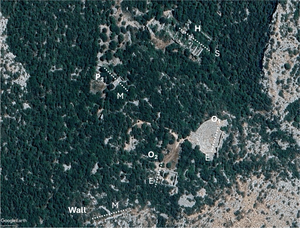
Alignments at Termessos relative to the Bering Sea pole. Current equinox sunrise direction which is 4 degrees south of east is shown for comparison (top left). Two kinds of stonework at Termossos at the amphitheater and bouleuterion (top center and right). Alignments of specific structures to the Bering Sea pole (bottom) include the amphitheater (O1), bouleuterion (O2), and portico (L3) cardinally aligned to the Bering Sea pole, building P3 and a wall aligned to major lunar standstills, and gymnasium (H) aligned to solstices relative to the Bering Sea pole. (Apple Maps, Sedat Boz/Google Earth and Ansgar Bovet/Creative Commons, and Turkish Museums).
Discussion
Is the long history of settlement in Anatolia from the late Neolithic to the present just the latest chapter in an even longer history of this region, extending back to the last ice age?
In contrast to the prevailing paradigm that modern human culture developed as a response to climate and ecological changes at the end of the ice age, Furter offers a different perspective:
The entire conscious, fundamentalist, common sense paradigm of archaeo astronomy is wrong. The “mysterious” thing in the cultural record, is that we have a large universal repertoire of standard subconscious behaviour. That behaviour is imprinted all over the cultural record. But our conscious mind finds it hard to see what is hidden in plain sight. The consequences for our self-image are significant. We did not invent, develop, or change culture. Culture is part of the human package, at least since Gobekli at BC 8000, cave art about BC 20 000, Blombos shelter about BC 70 000, and perhaps even Border Cave about BC 100 000, with the usual ensemble of tools, clothing, cosmetics, and trade. Human behaviour is static, and thus predictable, down to the structure of artworks and building sites.
If Furter is correct – that human behavior is static down to the structure of ancient sites, perhaps human societies have always aligned buildings to the Sun and the Moon. In other words, there is nothing special about Göbekli Tepe – it is simply an example of how the people at that time were expressing the same patterns of behavior that have existed throughout human history.
The inability of conventional archaeoastronomy to explain the alignment of so many ancient sites across the world has led to mixed approaches that often rely on local knowledge (context). Furter asks:
Could archaeo astronomy tell the difference between a myth cycle, a calendar, a zodiac, and a star map? And could it reveal the core content of culture, or explain perception? Correspondences simply mix and match shapes and star lore. Archaeo astronomy needs better theories, and a more scientific paradigm, to rise above the level of parlour games.
If crustal displacement theory is correct, by shifting the geographic reference frame we can explain the alignment of most ancient sites across the world using the same basic alignments we find at Göbekli Tepe, thus supporting Furter’s “universal repertoire” and offering a more scientific foundation (albeit tentative and hypothetical) for archaeoastronomy.
Click here to read a more detailed working paper.
(Feature image at the top of the article courtesy Sue Fleckney/Creative Commons)
Discover more from Before Atlantis
Subscribe to get the latest posts sent to your email.


Have there been studies that calibrate alignments based on the combo of Earth’s natural precession and crustal displacement [theory]?
Thanks for the article so full of fascinating details and mysteries, and for raising awareness about alignments and crustal displacement.
LikeLike
Hello! Not that I know of. Most theories about past civilizations are based on precession and the use of the zodiac to date ancient sites based on their alignment to stars assuming fixed geography (i.e., minimal crustal displacements). Crustal displacements affect how sites align geographically and thus astronomically. My analysis involves luni-solar alignments (e.g., equinox, solstices, and lunar standstills) which don’t change with precession but do change slightly with changes in Earth’s axial tilt. Analysis of site alignments with respect to the stars relative to previous poles would require a calibration as you suggest. Thanks for your question.
LikeLike