A New Theory of Earth Crustal Displacement

Breathing new life into Charles Hapgoodโ€™s theory of earth crustal displacement/pole shifts, a new paper proposes that short-term reversals of the geomagnetic field may โ€œunlockโ€ the crust sufficiently to allow tidal forces to pull it over the mantle in the same way they move earthโ€™s oceans. With existing climate theories unable to provide a satisfactory explanation of glacial cycles and ice ages, a revised version of Hapgood’s theory has been developed that explains sea-level changes resulting from the buildup and melting of polar ice over ice age/glacial cycles by a combination of Milankoviฤ‡ cycles and Hapgood pole shifts.

Click here to read the paper.

Watch a video presentation sponsored by the Society for Scientific Exploration.

Introduction

In this article, we begin by revisiting Hapgoodโ€™s theory of earth crustal displacement in the context of recent developments in climate and geoscience and show that it may be the missing link in understanding not only the rise and fall of past civilizations, as we first set out to do in Before Atlantis, but ice age/glacial cycles as well. A modified version of Hapgood’s theory is then described based on a new mechanism that is triggered by short-term reversals of the geomagnetic field that โ€œunlockโ€ the crust from the mantle and driven by earth-moon-sun tidal forces, the same forces that move earthโ€™s oceans. 

Courtesy University of Wisconsin-Madison.

Milankoviฤ‡ Cycles

In the 1920s, Milutin Milankoviฤ‡ proposed that changes in earthโ€™s eccentricity, axial tilt (obliquity), and precession result in cyclical variations in the amount of incident solar radiation (insolation) reaching the earth. Insolation is generally assumed to be a major driver of climate change over long periods. From 1โ€“3 million years ago, climate patterns were correlated with the earthโ€™s 41 Ky-long obliquity cycle. Then, about a million years ago, patterns began to follow a 100 Ky cycle that is between the 95 Ky and 125 Ky cycles in earthโ€™s orbital eccentricity. Why the period of climate patterns changed, the origin of the 100 Ky cycle, and why insolation lags rather than leads climate changes are among some of the problems that cannot be explained by Milankoviฤ‡ cycles. Perhaps the greatest shortfall of Milankoviฤ‡โ€™s theory is the inability of insolation in itself to accurately account for the periodic buildup and melting of polar ice over glacial cycles.

Average daily mean top of the atmosphere (TOA) insolation at 65ยฐN over the past 250 Ky and global sea level, which is inversely related to the amount of polar ice. 

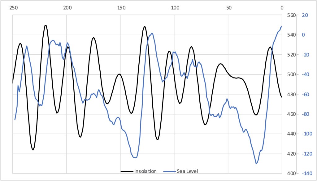
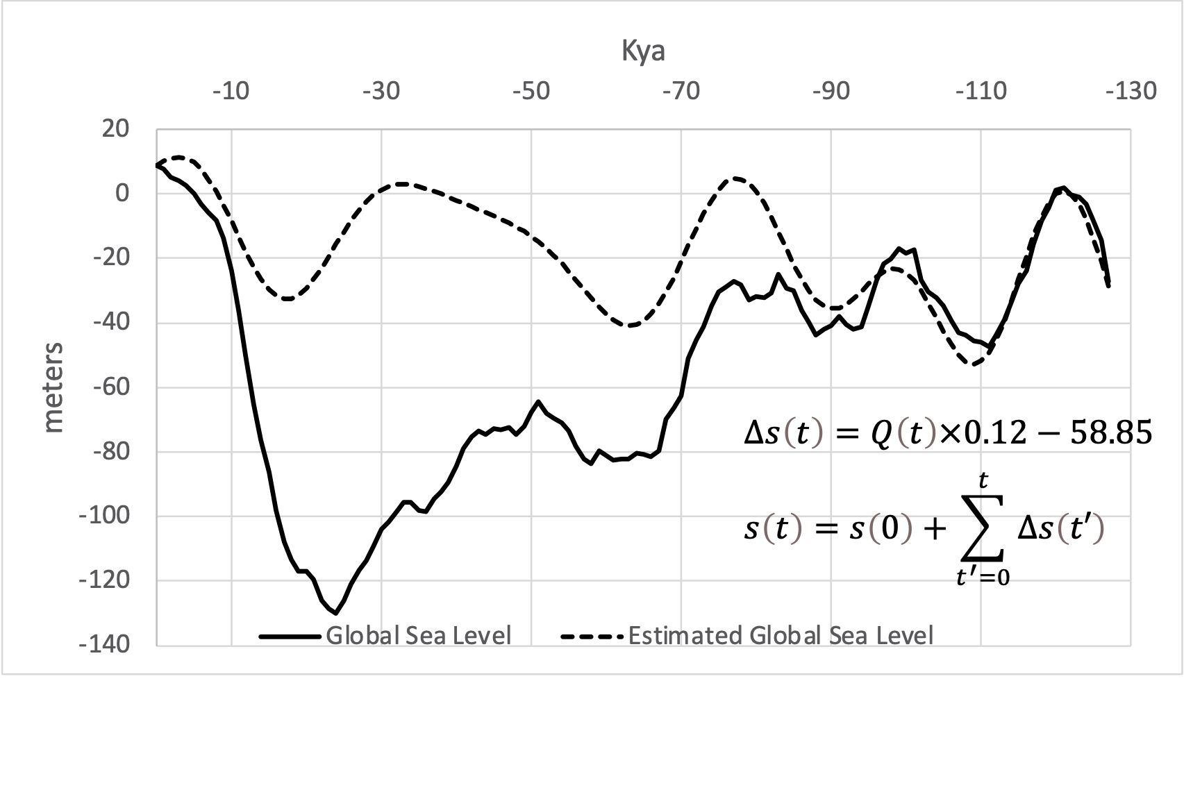
The two time series, insolation and global sea level, shown above are weakly correlated (R=0.14). There is a somewhat higher (R=0.33) correlation between insolation and temperature, and an even greater correlation (R=0.63) between insolation and changes in sea level as a function of time. The reason for the increased correlation is that as insolation increases, temperatures increase, polar ice melts, and sea levels rise. Conversely, as insolation decreases, temperatures decrease, precipitation freezes and accumulates at the poles, and sea levels fall. Exploiting this correlation, we can estimate mean sea level change โˆ†s(t) as a function of insolation Q(t) that when summed provide an estimate of sea level s(t) as a function of insolation over time.

Global sea level change predicted from insolation, which when summed provides an estimate of global sea level as a function of insolation.

What Insolation Does Not Predict

Over the last two glacial cycles, insolation tends to underpredict sea level (over predict polar ice) at the beginning of a cycle and over predict sea level (under predict polar ice) at the end. In other words, a greater amount of ice melts at the beginning and accumulates at the end of a glacial cycle than what is predicted by insolation. 

Difference between sea level predicted from insolation and actual sea level over the last glacial cycle.

Pole Shifts and Sea Level Changes

Insolation increases as we move toward the equator. Allowing the geographic location of the earthโ€™s poles to shift relative to the rotational axis as Hapgood proposed provides a means that can potentially account for the difference between the above sea-level curves. Before the start of a glacial cycle, a large amount of water is stored in an ice sheet around the pole. If the crust displaces enough to move the ice sheet out of the polar zone, the increased amount of solar radiation at lower latitudes will cause the ice to melt raising sea levels. After a period, an ice sheet begins to form at the new pole causing sea levels once again to fall.

Crustal displacements cause former polar regions to shift south toward the equator.(Google Earth)

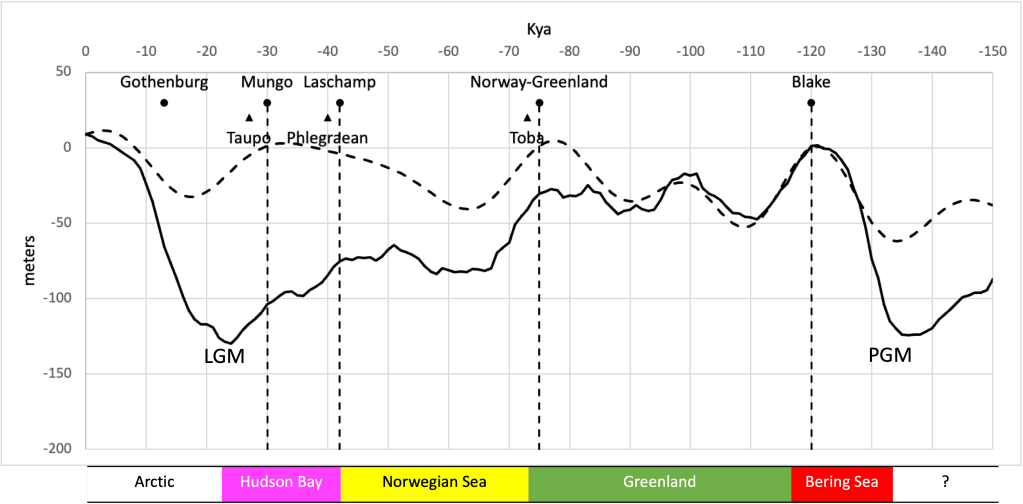
Sea levels decrease in stages during a glacial cycle suggesting a continued buildup of ice near the poles. Notice the land area around the pole is different at different pole locations. Since ice forms and accumulates more readily on land than over the ocean, if the land area at the new pole is greater than the land area at the old pole, sea levels after a pole shift should eventually fall to a lower level as there is a greater area for ice to accumulate. Based on measurements of land area in the Arctic circle and former polar regions there is a strong correlation between the size of the ice sheet (assumed to be determined by land area) and sea level for the current and four prior pole locations. Successive increases in available land area following the Bering Sea to Greenland pole shift have led to successive decreases in sea level. This suggests that the magnitude of crustal displacements during a glacial cycle, i.e., before the last glacial maximum (LGM) and penultimate glacial maximum (PGM) were small enough to keep the accumulating mass of ice in the polar zone. The precipitous rise in sea level after the LGM and PGM suggests that larger magnitude crustal displacements shifted the ice sheet farther south to melt a significant fraction of the accumulated ice. 

A Possible Mechanism for Crustal Displacements

In his original theory, Hapgood proposed polar ice creates mass imbalances that can cause the crust to slip over the mantle shifting the geographic location of the North Pole. Einstein later argued that the force of the ice was not sufficient to cause a crustal displacement. Using models of the crust and ice sheets at the LGM to estimate the degree to which the ice could have affected the earthโ€™s moments of inertia, it has been determined that if the crust were free to move, the ice would have shifted the pole by less than 0.25ยฐ relative to its present position. 

If the first part of Hapgoodโ€™s theory is wrong, that ice cannot move the pole, is there another way to save the rest of his theory?

An analysis of alternative mass distribution models reveals the theoretical axis of rotation (TRA) of the crust deviates significantly from the earthโ€™s rotational axis and so may not be in equilibrium with the earth. We have determined the crustโ€™s TRA is at 1.21ยฐN, 18.52ยฐ W. This location lies in the zone of the tropics almost on the equator. At the equinox, the equator is parallel with the ecliptic plane. At other times of the year, the ecliptic passes through the earthโ€™s equatorial region between the tropics of Cancer and Capricorn. The path of the sun, moon and most other bodies in the solar system lies along the ecliptic. That the crustโ€™s TRA points in this direction suggest the possibility the crustal disequilibrium may have an external (i.e., extraterrestrial) cause.

The influence of the moon, and to a lesser extent, the sun, are responsible for the earthโ€™s tides. The balance between gravitational and centrifugal forces causes the earth (primarily its oceans) to elongate in the direction of the moon by 1.34 meters and the direction of the sun by 0.61 meters. As the earth rotates, tidal forces cause the oceans to rise and fall twice a day. These forces also pull on the crust. It has been proposed that tidal forces acting on the crust could be a possible trigger for certain kinds of earthquakes. 

Possible role of tidal forces in changing the position of the crustโ€™s theoretical axis of rotation (TRA).

Tidal torques acting on the earth and moon dissipate energy. With the crust โ€œlockedโ€ to the mantle, the energy loss manifests as the frictional heating of the crust and oceans. If, however, the crust became โ€œunlockedโ€ the effective work could result in a displacement of the crust over the mantle. The key to crustal displacement thus becomes the question of whether there is a way for the crust to become unlocked from the mantle. 

A growing body of evidence suggests changes in the earthโ€™s magnetic field may influence climate. Over the last 83 million years, 183 geomagnetic reversals have taken place in which the poles changed polarity. Geomagnetic reversals occur, on average, 450 Ky years apart. Long periods (millions of years) in which the magnetic poles do not flip preceded the four largest extinctions on earth: the Cretaceous-Tertiary (KT), Triassic-Jurassic (TJ), and the Permo-Triassic (PT) and Guadalupian-Tatarian (GT) doublet. Between geomagnetic reversals, events known as geomagnetic excursions take place where the field temporarily reverses for a shorter period (thousands of years or less).

Earthโ€™s magnetic field (top). Bottom left to right shows the normal polarity of core and crust, polarity during a geomagnetic excursion, rotation of crust, and return to original field polarity

One possibility is that changes in the magnetic field during a geomagnetic excursion may affect the ease with which the crust can move over the mantle. Magnetic dipoles of ferromagnetic minerals in the crust normally line up in the same direction as those in the core resulting in continental ferromagnetic fields. It is conjectured that when the core magnetic field flips during a geomagnetic excursion, the dipoles in the crust temporarily point in the opposite direction to produce a repulsive force between the crust and core fields. If this force, perpendicular to the crust, is sufficient to reduce the frictional force between the crust and mantle, it may be possible for forces acting on the crust parallel to the surface to move the crust over the mantle while the geomagnetic field is reversed. When the geomagnetic field flips back the crust is once again locked to the mantle maintaining disequilibrium.

Sea level predicted from insolation (dotted) and actual (solid) curves. Approximate dates of geomagnetic excursions (circles) and volcanic eruptions (triangles).

Correlated Events

Although there is no way to test our conjecture directly, correlations between geomagnetic excursions, super-volcanic eruptions, and glacial events could imply causation. The Blake geomagnetic excursion occurred 15โ€“20 Ky after the PGM. The Volcanic Explosivity Index (VEI) is a relative measure of the explosiveness of volcanic eruptions.  The next two geomagnetic excursions were each followed by massive VEI 8 magnitude volcanic eruptions. The most recent Toba eruption 73โ€“75 Kya followed the Norwegian-Greenland Sea excursion. The Oruanui eruption of New Zealandโ€™s Taupo volcano followed the Lake Mungo excursion 28โ€“30 Kya. The somewhat smaller VEI 7 Phlegraean Fields eruption followed the Laschamp event 40โ€“42 Kya.

Although the trigger mechanism for geomagnetic reversals is not clear, crustal shifts could provide an explanation for earthquake activity, volcanic eruptions, and other events that follow geomagnetic excursions. The Blake, Norwegian-Greenland Sea and Lachamps geomagnetic excursions precede three episodes of sea level decline/increase of polar ice. The Lake Mungo geomagnetic excursion occurs just before the LGM after which global sea levels began to rise to current levels. According to the model, crustal displacement(s) triggered by the Mungo Lake and possibly the Gothenburg geomagnetic excursions shifted most of the ice sheet that had formed up to the LGM almost 2,000 miles south well into the temperate zone leading to rapid melting and sea-level rise. The Younger Dryas event was also likely a significant contributor to glacial melt. All four events appear to be somewhat correlated with Milankoviฤ‡ cycles evident in the insolation curve. Three precede major volcanic eruptions. 

Conclusion

We show how Hapgood pole shifts working in conjunction with Milankoviฤ‡ cycles provide a possible explanation for climate changes over past glacial cycles. That the crust does not appear to be in equilibrium with the whole earth in terms of their moments of inertia suggests the possibility that an unknown force could be at work. We propose earth-moon-sun tidal forces may be responsible, and that these forces, which move the earthโ€™s oceans might provide sufficient energy to displace the crust a significant distance during a geomagnetic excursion. It is our hope that these new findings will lead to further work in these and other related areas of research.

The featured image at the top of the article was captured by the astronauts about the International Space Station.

Rome Wasn’t Built In a Day: New Evidence the Eternal City May be Older Than We Think

Although most historical accounts are rooted in the legendary founding of Rome by Romulus and Remus in 753 BCE we present new evidence based on astronomical alignments that the place we now call Rome may have been first established tens of thousands of years earlier.

Click here to download paper from SSRN.

Introduction

Analysis of the alignment of Roman towns reveals the distribution of geographic orientations is decidedly non-random (Magli 2008). Most are laid out in solar directions from due east-west to directions north and south that are within the range of sunrise/sunset directions over the course of the year. These alignments span the range of lunar directions except for extreme northerly and southerly moonrises and moonsets at the time of major lunar standstills which occur every 18.6 years. Spiravigna (2016) has found evidence of lunar alignments at Roman sites including the Decumani of Naples, Augusta Emerita, known today as Merida, in Spain, and Curia Julia in the Forum of Rome. 

Lunar Alignments

Most are familiar with the seasonal path of the sun โ€“ that it rises in the east and sets in the west, more or less. The motion of the moon, however, is more complex and perhaps, as a result, is seen as being more mysterious. The moonโ€™s movements are more complex than the sunโ€™s for several reasons. The moon completes one orbit around us in a much shorter time than we do around the sun and so does in a month what the sun does in a year, in terms of the changing rising and setting direction along the horizon. The plane of the moonโ€™s orbit is tilted by 5.1ยฐ relative to the ecliptic and so can rise and set more northerly and more southerly than the sun. Due to the effects of the sunโ€™s gravity, the moonโ€™s orbital plane does not stay fixed in space but precesses, causing the monthly angles of moonrise and moonset to change over an 18.6-year cycle. Every 18.6 years the moon rises and sets at its maximum northerly and southerly directions, which is known as a major lunar standstill. 9.3 years later a minor lunar standstill occurs when the moon rises and sets at its minimum northerly and southerly directions. Both of these times appear to have been important to ancient builders throughout the world.

Ancient ruins on Palatine Hill.

The City of Rome

According to legend, the city of Rome was founded by the sons of Mars, the twin brothers Romulus and Remus on April 21, 753 BCE. Seven hills comprise the city of Rome. Temples dedicated to the Roman goddess Luna once existed on Aventine and Palatine hills.

The alignment of grid patterns on both Aventine and Palatine hills lie in the direction of most southerly moonrises and northerly moonsets. The alignment of the Roman Senate building, Curia Julia, in the Roman Forum is in the direction of most northerly moonrises and southerly moonsets. Alignments in all three areas are in major lunar standstill directions.

The Field of Mars

West of the old city lies Campus Martius – The Field of Mars. One of the oldest Roman temples, the Pantheon, is here just east of Piazza Navona. Unlike the Roman Forum, and Palatine and Aventine hills, this part of Rome is laid out in a direction that currently has no known astronomical or geographic significance. 

In a study of more than two hundred archaeological sites (Carlotto 2020a), it was discovered that the alignment of almost half of the sites examined could not be explained in terms of known directions. Approximately 80% of the sites were found to reference four locations within 30ยฐ of the North Pole (Carlotto 2019a) that, if Hapgoodโ€™s theory of earth crustal displacement is correct, could have been former locations of the North Pole over the past 100,000 years (Carlotto 2020b). 

The orientation of the Pantheon (right) and surrounding area including the Piazza Navona (left) are in the direction of major lunar standstills relative to the Hudson Bay pole.

The Pantheon is one of these sites. Shifting the geographic reference point from the current North Pole to a previous pole in Hudson Bay, the Pantheon and surrounding area become aligned in the direction of major lunar standstills relative to the Hudson Bay pole. Based on the chronology established by Gaffney (2020), if the Romans had built the Pantheon over a previous structure that was aligned to a former pole in Hudson Hay, based on its alignment, the original site could have been established at least 12,000 to 18,000 years ago.

Ancient Foundations

Examples of newer structures built over older pre-existing structures can be found throughout the world. Seven stages of construction are evident at Baalbek. Under the Parthenon in Athens lies an older Parthenon (Beard 2010). There are many examples of this practice, now known as adaptive reuse, in Rome. Walking through the old city modern buildings built over and alongside ancient ruins are everywhere.

Previous constructions at San Clemente basilica (https://brewminate.com/adaptive-reuse-of-ancient-buildings-in-rome/)

But what lies underneath Rome? According to Tom Mueller in his article โ€œUnderground Rome,โ€ something is buried beneath everything in Rome. Roman architects tore the roofs from old buildings filled their interiors and used them as foundations for newer structures. Four levels have been excavated within San Clemente, a twelfth-century basilica just east of the Coliseum. 

Descend the staircase in the sacristy and you find yourself in a rectangular hall decorated with fading frescoes and greenish marbles, lit by sparse bulbs strung up by the excavators. This is the original, fourth-century San Clemente, one of Rome’s first churches. It was condemned around A.D. 1100 and packed full of earth, Roman-style, as a platform for the present basilica. A narrow stair near the apse of this lower church leads down to the first-century structures upon which it, in turn, was built: a Roman apartment house and a small temple. The light is thinner here; cresses and fungi patch the dark brick and grow delicate halos on the walls behind the bare bulbs. Deeper still, on the fourth level, are several rooms from an enormous public building that was apparently destroyed in the Great Fire and then buried by Nero’s architects. At about a dozen yards below ground the massive tufa blocks and herringbone brickwork are slick with humidity, and everywhere is the sound of water, flowing in original Roman pipes. No one has excavated below this level, but something is there, for the tufa walls run another twenty feet or so down into the earth.[5]

The fourth-century church was filled with rubble and used as the foundation of the current basilica, whose aisle and nave were lined up with that of the one below it. In this way, the alignment of the original structure defines that of later structures built over and around it.

The Oculus

Spiravigna (2018) considers the question of what could have been seen through the opening (oculus) of the Pantheon. Rome is located approximately 42ยฐ north of the Equator. Relative to the Hudson Bay pole, its latitude would have been about 35ยฐ.

35ยฐ parallel relative to current pole (bottom) and Hudson Bay pole (top).

Earthโ€™s axial tilt or obliquity is currently 23.5ยฐ. Numerical models suggest the obliquity, which varies cyclically could be as large as 24.5ยฐ. The declination of the moon at a major standstill at maximum obliquity would be approximately 24.5 + 5.1 = 29.6ยฐ. The diameter of this opening or oculus at the top of the structure subtends a 10ยฐ region centered at the zenith. The angular diameter of the moon is about 0.5ยฐ and so would have been almost visible through the oculus at this time from below. If one looked up and stepped back toward the doorway, the moon would become visible at its zenith.

Side view of the Pantheon. Directly below the oculus, the moon would be hidden. Walking a few steps to the north the limb of the moon would become visible during a major lunar standstill.

Discussion

The Parthenon is thought to have been aligned toward sunrise on August 15, the date of Athenaโ€™s birthday (Carlotto 2019b). Using a similar rationale, we have been unable to find any structure in Rome aligned in the direction of sunrise (74ยฐ) or sunset (286ยฐ) on the cityโ€™s founding date of April 21. The orientation of the Roman Forum (294ยฐ), which is well north of this direction, like structures on Palatine and Aventine hills, is aligned to lunar standstills, in this case, minor standstills.

Worship of the moon is thought to have originated in the early years of the Roman Kingdom. That so much of ancient Rome is aligned to the moon and one of its oldest buildings, the Pantheon, is aligned to the moon relative to the Hudson Bay pole may be no coincidence, particularly in light of the Roman practice of building over older structures, a practice that they could have inherited from an earlier civilization that also held a special reverence for the moon.

References

Giulio Magli (2008), โ€œOn the orientation of Roman towns in Italy,โ€ Oxford Journal of Archaeology 27 (1), 63–71.

Mary Beard, The Parthenon, rev. ed. (Harvard University Press, 2010).

Amelia Carolina Sparavigna (May 29, 2016) โ€œThe Decumani of Naples and the Minor Lunar Standstill,โ€ PHILICA, Article number 608. Available at SSRN: https://ssrn.com/abstract=2786259.

Amelia Carolina Sparavigna (July 10, 2016) โ€œAugusta Emerita and the Major Lunar Standstill of 24 BC,โ€ PHILICA Article Number 635, Available at SSRN: https://ssrn.com/abstract=2807544.

Amelia Carolina Sparavigna (July 19, 2016) โ€œ A Possible Astronomical Orientation of the Curia Julia in the Forum of Rome,โ€ PHILICA Article number 639, Available at SSRN: https://ssrn.com/abstract=2811625.

Amelia Carolina Sparavigna and Lidia Dastrรน (May 27, 2018) โ€œThe Pantheon, eye of Rome, and its glimpse of the sky,โ€ Available at HAL: https://hal.archives-ouvertes.fr/hal-01800694.

Mark Carlotto (2019a) โ€œArchaeological Dating Using a Data Fusion Approach,” SPIE Defense + Commercial Sensing Conference on Signal Processing, Sensor/Information Fusion, and Target Recognition XXVIII (11018), Baltimore MD, April 14-18, 2019.     

Mark Carlotto (2019b) โ€œNew Models to Explain the Alignments of Greek Temples.โ€ Available at SSRN: https://ssrn.com/abstract=3501950 or http://dx.doi.org/10.2139/ssrn.3501950

Mark Gaffney (2020) Deep History and the Ages of Man. Independently Published.

Mark Carlotto (2020a) โ€œAn Analysis of the Alignment of Archaeological Sites,โ€ Journal of Scientific Exploration 34(1):13. DOI: 10.31275/2020/1617

Mark Carlotto (2020b) โ€œA New Model to Explain the Alignment of Certain Ancient Sites,โ€ Journal of Scientific Exploration 34(2):209-232. DOI: 10.31275/20201619

Mark Carlotto (2022) โ€œToward a New Theory of Earth Crustal Displacement,โ€ Journal of Scientific Exploration 36(1):8-23. DOI: 10.31275/20221621


Featured image at the top of the article courtesy Jรถrg Bittner (Unna). Creative Commons.