A New Interpretation and Dating of the Sphinx based on the Moon

This article explores the possibility that the Great Sphinx in Egypt was conceived as a temple to a lunar deity in the form of a lion facing the rising of a full moon circa 21,000 BCE. We hypothesize an alignment at the fall equinox with the sun setting behind the Sphinx instead of in front of it at the spring equinox as Bauval and Hancock have proposed. Based on predictions derived from Charles Hapgoodโ€™s theory of earth crustal displacement, this hypothesis places the origin and early history of the Sphinx in the tropics where heavy rainfall over time could have eroded the original structure so as to appear as it does today.

Introduction

The Sphinx is thought to have been built by the 4th-dynasty pharaoh Khafre, around 2500 BCE. Inspired by the research of Schwaller de Lubicz, John Anthony West believed it to be much older. West along with geologist Robert Schoch proposed a dating of 5000 BCE based on indications of water erosion, water erosion that could only have occurred when the climate was wetter. Graham Hancock and Robert Bauval suggested the Sphinx was built circa 10,500 BCE in the astrological age of Leo. They believed the symbolism of the Sphinx facing the sun as it rose on the first day of spring โ€œmirroredโ€ the alignment of the sun in the sky with the constellation Leo at that time. West later went on to propose an even earlier date of 36,000 BCE during the time of the legendary predynastic rules of Egypt.

A Warmer Wetter Egypt

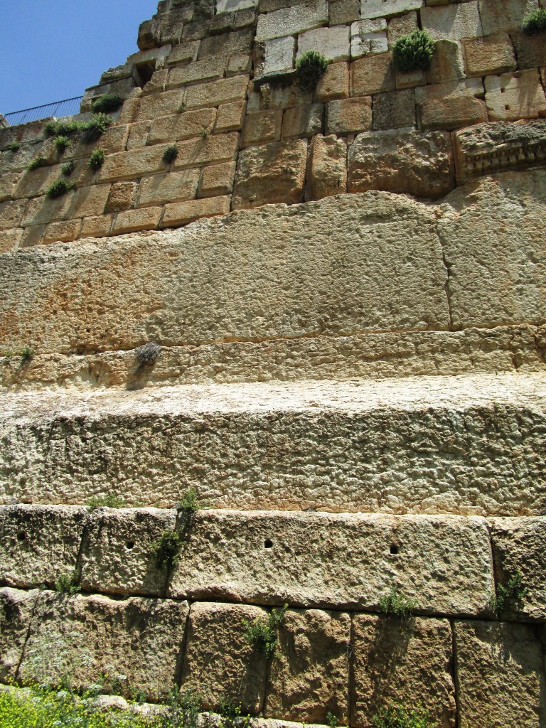
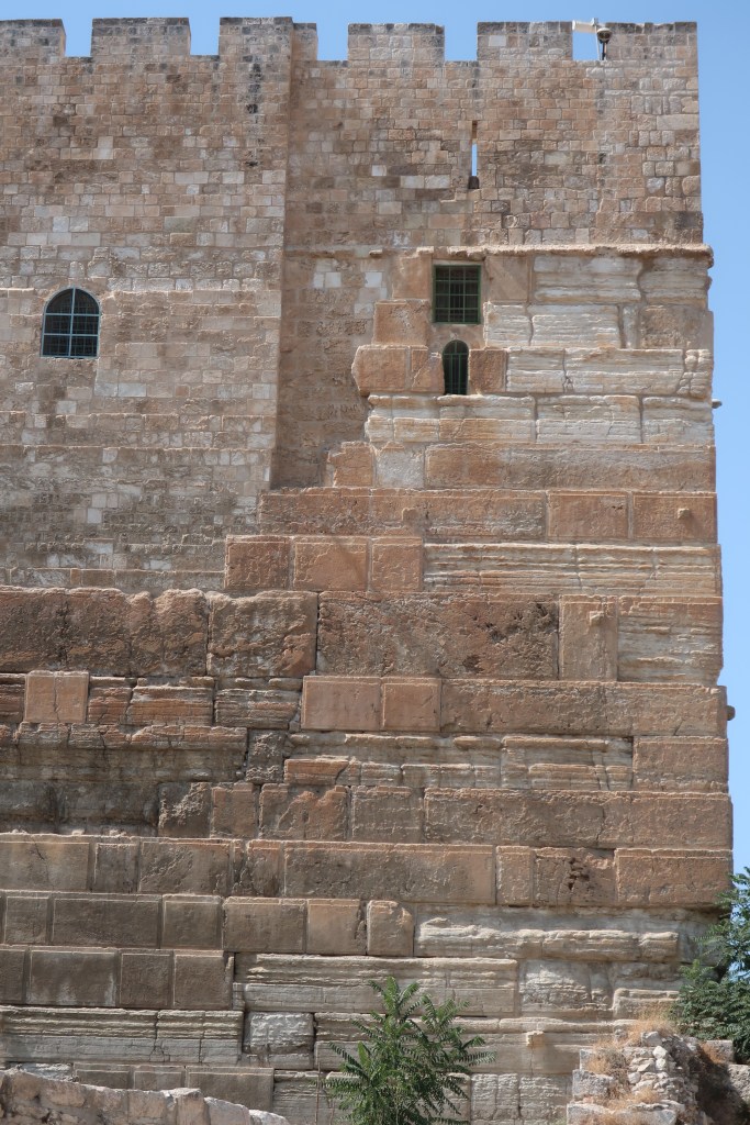
Evidence of water erosion on the Sphinx suggests that it once existed within a much wetter environment. Today, the climate in Lower Egypt is dry due to it being north of the tropic of Cancer within the range of latitudes in the northern hemisphere that has the least amount of rainfall. 

Climate zones relative to the Hudson Bay pole. Egypt would have been located in the tropical zone between the red and orange lines.

Charles Hapgood proposed that ice ages and other climate events were due to displacements of the earthโ€™s crust that shifted the geographic location of the North Pole. As the pole shifts, so too do climate zones. If the North Pole were in Hudson Bay before the latest crustal displacement, which Hapgood estimated occurred 12,000 to 18,000 years ago, Egypt would have had a warm and wet climate.

Anomalous Alignments in Giza

Before Atlantis considers the archaeological implications of Hapgoodโ€™s theory, in particular, that certain ancient sites were aligned to previous locations of the geographic pole. In Giza, if the geographic pole were in Hudson Bay, North would have been about 30ยฐ west from its current direction. 

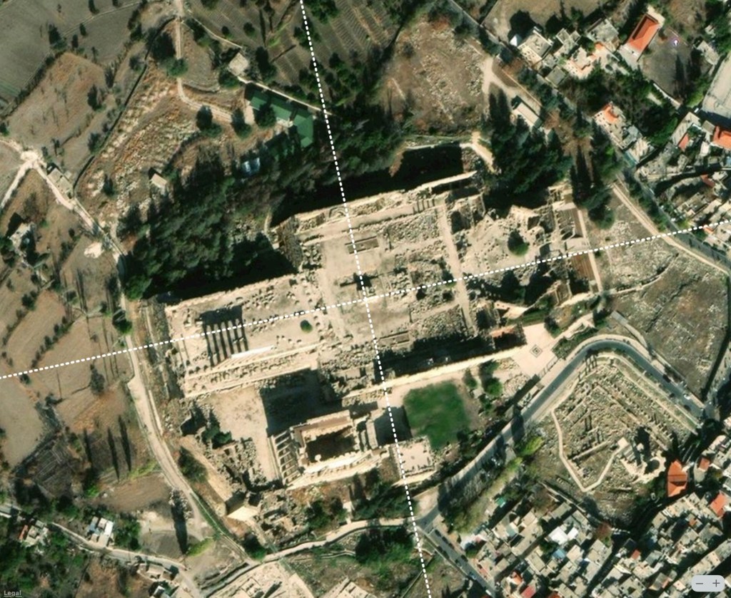
The three great pyramids and associated temples in Giza are accurately aligned within fractions of a degree to north. Much of the surrounding area contains later-day tombs, settlements, and other structures that are similarly aligned although not as accurately. Like the pyramids, the Sphinx also appears to be aligned to the cardinal directions. 

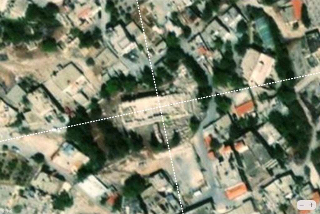
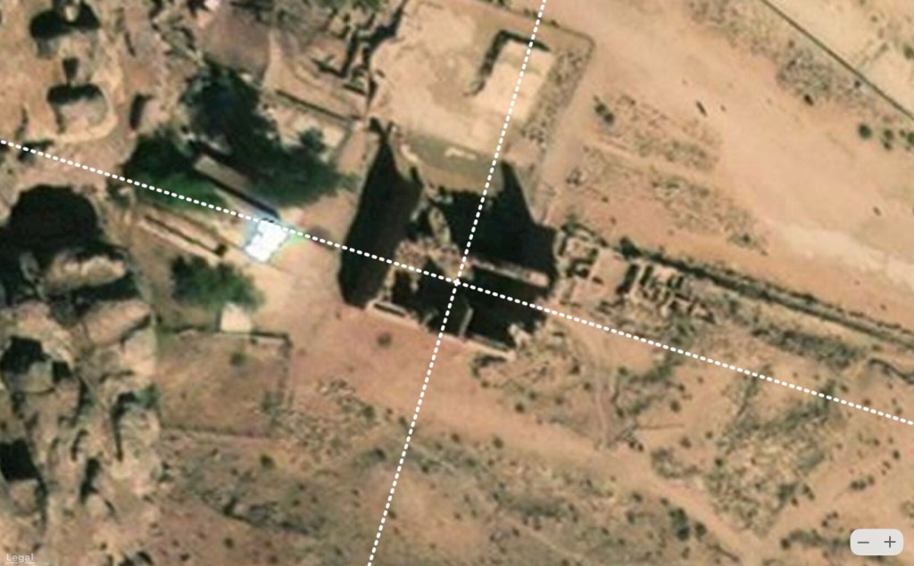
An area surrounding the Sphinx on the east side of the Giza Necropolis contains structures that are aligned differently. The Temple of Amenhotep II northeast of the Sphinx is rotated about 45ยฐ clockwise from the cardinal directions. The temple was built over the then yet to be revealed temple in front of the Sphinx that was discovered after his son Thutmose IV excavated the Sphinx around 1400 BCE. The Pyramid of Khentkaus I is a two-stepped tomb south of the Sphinx that was constructed during the 4th-dynasty. The tomb, built in two phases coinciding with its two steps, was originally known as the fourth pyramid of Giza. It is unusual in that unlike the other three Giza pyramids this structure is misaligned by a considerable amount, about 6ยฐ west of north.

What is interesting about the Hudson Bay pole hypothesis is that it explains the alignment of these two structures in a simple way. If the North Pole were in Hudson Bay, the Temple of Amenhotep II would be aligned in the direction of minor lunar standstills. The Pyramid of Khentkaus I and neighboring structures east and west would have been aligned in the direction of the winter solstice sunrise/summer solstice sunset relative to the Hudson Bay pole. Even more interesting, we find that the direction of major lunar standstills circa 21,000 BCE corresponds to due east today. In other words if the Sphinx were originally built in alignment with the moon at this time, after the pole shift from Hudson Bay it would now appear to be cardinally aligned.

Alignments to the Moon 

According to Wendell  Phillips, the โ€œIndiana Jonesโ€ of his time, โ€œthe moon was the chief deity of all the early South Arabian kingdoms โ€“ particularly fitting in that region where the soft light of the moon brought the rest and cool winds of night as relief from the blinding sun and scorching heat of day.โ€ 

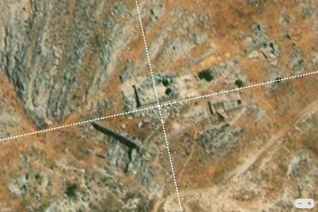
Sites dedicated to moon gods exist throughout Arabia to the east. The ancient cities of Timna and Marโ€™ib along the southern border of the Rubโ€™al Khali are aligned in the direction of minor lunar standstills. The Temple of Awwam in Marโ€™ib, dedicated to the moon god  Ilumquh is aligned to sun and moon relative to the Hudson Bay pole. Structures in the ancient town of Shabwa to the east are also aligned to the moon relative to the direction of the Hudson Bay pole. (See a previous article for a discussion of these sites.)

A Lunar Temple?

In considering the widespread worship of the moon in this part of the world, was the Sphinx, once thought to have been the representation of a lion, actually a shrine to a lunar deity? 

Lions do not live in arid desert regions but in warm tropical savannas. Like most predators, they sleep during the day and hunt at night. 
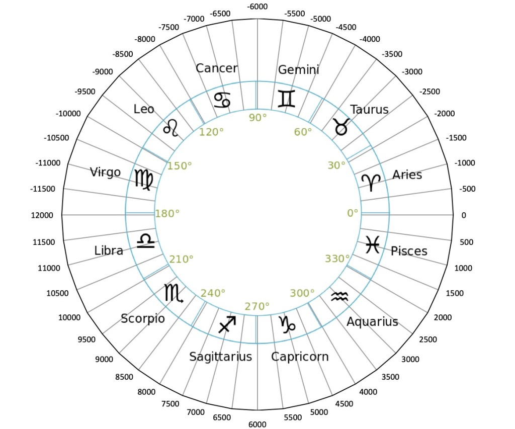
Lion at sunset. (Photo by Lynn Carlotto)

Westโ€™s 36,000 year-old dating of the Sphinx is Bauval and Hancockโ€™s plus one precessional cycle of 24,000 years. At that time the sun would have risen in the constellation Leo, and set in Aquarius on the spring equinox. One half precessional cycle earlier, circa 21,000 BCE, the situation would have been reversed with the sun rising in Aquarius and setting in Leo.

24,000 year processional cycle divided into 12 astrological ages.

One can argue that the symbolism of a lion sitting upright at twilight with the sun setting behind it in the constellation Leo, facing the moon as it rises in the opposite direction, is just as compelling (perhaps even more so) as that of a lion facing the sunrise.ย 

A Complex Argument

Similar to Marco Vigatoโ€™s argument that the Giza pyramids could have once been earlier predynastic mastabas or similar structures that were later expanded into pyramids, could the base of the Pyramid of Khentkaus have been built even earlier before the last pole shift aligned to the solstices relative to the pole at the time, the Hudson Bay pole?

Clearly, the Temple of Amenhotep II built over the Sphinx Temple has nothing to do with the origin of the Sphinx itself. However, its presence in Giza together with similarly aligned sites in Upper Egypt suggests the Egyptians aligned structures to the sun and moon relative to the current and previous geographic poles and so could have aligned the Sphinx in this manner as well.

The Temple of Karnak, Hypostyle Hall, Temple of Thutmose II, and Temple of Ramesses II are all lined up in the direction of the winter solstice sunrise/summer solstice sunset relative to the current pole in the Arctic. The Mortuary Temple of Thutmose III and the Colossi of Memnon in Thebes are also aligned in this direction, about 26ยฐ south of east, along with the Mortuary Temple of Hatshepsut. The Mut Temple in Luxor is aligned in a direction a few degrees away that is toward minor lunar standstills.

There are other sites in Upper Egypt oriented in directions around 45ยฐ south of east that are not currently aligned to the sun or moon. One possibility is they were aligned to the stars as proposed by Norman Lockyer. Another is that they were aligned to the sun and moon relative to previous poles.  An analysis of Luxor Temple reveals two sections are aligned with solstices and minor lunar standstills relative to the Hudson Bay pole. Across the Nile River, the Ramasseum is aligned to major lunar standstills relative to the Hudson Bay pole. 

The Temple of Amenhotep II in Giza is aligned in the same direction as the Ramasseum in the Theban Necropolis more than 300 miles away. The Mortuary Temple of Thutmose III in Thebes is aligned to solstices relative to the Hudson Bay pole as is the Pyramid of Khentkaus. Why did father and son rulers Thutmose III and Amenhotep II align temples in Giza and Thebes to directions that have no obvious reference other than to the Hudson Bay pole?

Over 60 temples, mostly in Upper Egypt, are aligned to previous hypothesized locations of the North Pole. A study of how these alignments correlate with different rulers could provide further insight into the question of whether the structures were built over earlier sites or oriented in โ€œsacred directionsโ€ in acknowledgment of mythical rulers or โ€œgodsโ€ of past ages.


Featured image at the top of the article is a painting by K. F. Schinkel entitled “Garden scene with the Sphinx in moonlight.”

New Evidence of Prehistoric Civilizations in the Holy Land and Surrounding Regions of the Levant

The Holy Land and surrounding regions in the Levant contain some of the most sacred and enigmatic places in the world. It has been determined that some of these places contain structures that are aligned to what could have been previous locations of the North Pole over the past 100,000 years or more. This article reveals that these places are not exceptional in this regard but are among numerous other sites in this part of the world that appear to be aligned to former poles and thus could be much older than mainstream archaeological theories maintain.

Click here to read the full paper.

I put to Emir Hangar the question, who built Baalbeck? His answer was โ€“ “There have been three builders; the first was Sanoud, the second was (I have forgotten the name), and then came the Deluge; after that it was repaired by Solomon.”

David Urquhardt, The Lebanon: A History and a Diary, 1860

Baalbek

This site on which a succession of temples and other structures have been built contains, at its base, the largest megalithic blocks in the world. In all, seven stages of construction are evident. The plan of the original structure is a square enclosure (Urquhardt 1860):

A small portion only of this has been completed in the old work, namely, the angle of the north-west, and the adjoining walls. It is there that may be seen the 70 feet stones built into the walls in tiers, and hoisted up 20 feet, and placed on several layers of smaller stones. 

Two unknown periods of construction are above this:

The remainder of the space is filled up with piles of stones, entirely of another order. Through these, two vaults are open, leading to the inference, that it is all vaulted below: these again may be divided into two orders; one [second period] may be called Cyclopic, the stones being irregular, the sides varying from 5 to 6 and 7 feet. The other [third period] is more systematic, and combines some thing of the Etruscan and the Egyptian, an arch being traceable in the one style, and a portal in the other.

Platform of the Temple of Jupiter, west wall, triliton (Baalbek). (Creative Commons/Lodo27)

Above these ancient foundations are four historical periods of construction. According to Urquhardt

In one of the vaults, about eight feet from the ground, a stone has, by some accident, been removed, and my attention having been called to it by traces of fodder, I had myself lifted up, and got into a crypt beyondโ€ฆ I could not doubt that I stood in a Phoenician Temple, perhaps the only one that still exists.

Next are the restored Greek and Roman ruins, an enormous peristyle known as the Temple of Jupiter.

Robinson (1852) describes Baalbekโ€™s megalithic foundation in greater detail:

Not less wonderful than the other parts of the great temple are the immense external substructions, by which the walls supporting the peristyle are enclosed and covered; if indeed that term can be properly applied to huge masses of masonry, on which nothing rests. This external substruction wall is found on the north side and west end of the peristyle; and exists also probably on the south side beneath the mounds of rubbishโ€ฆ

The most imposing of these substructions is the western wall, as viewed from the outside. It rises to the level of the bottom of the columns, some fifty feet above the surface of the ground; and in it is seen the layer of three immense stones celebrated by all travelers. Of these stones, the length of one is sixty-four feet; of another, sixty-three feet eight inches; and of the third, sixty-three feet; in all one hundred ninety feet eight inches. Their height is about thirteen feet; and the thickness apparently the same, or perhaps greater. They are laid about twenty feet above the ground; and below them are seven others of like thickness, and extending somewhat beyond the upper ones at each end.

In a quarry less than a kilometer from the temple lies an enormous stone block approximately 20 x 4 x 4 meters in size and weighing an estimated one thousand tons. It is likely the quarry dates back to the time of the original construction:

On the north, the substruction wall is only about twenty feet in height, and was never completed. It also is built up of cyclopean work; immense stones laid as brought from the quarry, but never dressed smooth. Here are nine stones, measuring on an average thirty-one feet in length, nine feet seven inches in breadth, and thirteen feet in depth. In speaking of the huge block still lying in the quarry, I have said that there would seem to be no place for it in the plan of the present structures. Still, it may not be impossible, that the said block was intended to be placed upon this very wall, in a line with the similar course at the west end; but for some reason the work was abandoned, and the wall left in its present unfinished state.

Interesting, like the uncompleted temple at Ollantaytambo containing the Wall of the Six Monoliths, the megalithic foundations at Baalbek were never completed. To Urquhardt, its great antiquity is clear:

The builders of Baalbeck must have been a people who had attained to the highest pinnacle of power and science; and this region must have been the centre of their dominion. We are perfectly acquainted with the nations who have flourished here or around, and their works; they are the Assyrians, Chaldeans, Medes, Persians, Egyptians, Canaanites, and Jews. These complete the catalogue of ancient empires, and this work is none of theirs.

Baalbek is cardinally-alignment with respect to the Greenland pole. (Apple Maps)

The orientation of the original square enclosure is rotated approximately 12ยฐ west of north. This direction, which has no known astronomical or cultural significance, points directly toward the Greenland pole. By virtue to its alignment to this former pole the earliest foundations at Baalbek could be 85,000 to 130,000 years old.

Jerusalem

No less remarkable than Baalbek are the megalithic foundations in Jerusalem. The Temple Mount is a flat trapezoidal plaza surrounded by retaining walls built during the reign of Herod. The northern wall, together with the northern section of the western wall, is hidden behind residential buildings. The eastern wall is 1530 feet long and oriented approximately 7.5ยฐ west of north. The western wall, which includes the Wailing Wall, is about 1560 feet long and oriented 11.5ยฐ west of north. The southern wall, a little over 900 feet long, is laid out at a right angle to the western wall. Robinson (1852) observes:

A comparison of the antique portions of the southern wall with the masonry of the Jews’ wailing place, and that at the southwest and southeast corners, left upon our minds the strong impression, that instead of this portion of the substructions being of later date than those further north, these remains of the southern wall and southeast corner present decided evidence of higher antiquity, than almost any other portions.

Temple Mount enclosure, showing the courses of stone. (Creative Commons/Davidbena)

The largest stone block is in a section of the western wall foundation that is now below ground. Its estimated weight is 200-300 tons. According to Robinson โ€œit might certainly be conceded that Herod may at least have rebuilt these vaults and substructions upon more ancient foundations. In this way, if necessary, most of the present appearances might doubtless be satisfactorily accounted for.โ€

The cardinal orientation of the site, defined by its western and southern walls to the Greenland pole, suggests the original foundations that defined the plan of Temple Mount, such as those at Baalbek, could be 85,000 to 130,000 years old. Like the Romans, nearly a thousand years later, perhaps Solomon built his temple over an even more ancient foundations that had already been in existence for many tens of thousands of years.

Western and southern walls of Temple Mount are aligned to the Greenland pole. (Apple Maps)

Other Sites Aligned to the Greenland Pole

Of all the former poles, almost as many sites are aligned to the Greenland pole alone than to the current North Pole. A site known as Ain Dara in northern Syria noted for its similarities to King Solomon’s Temple is aligned to the summer solstice sunrise/winter solstice sunset relative to the Greenland pole. Several Roman temples in Niha, Lebanon are aligned in the direction of the Greenland pole, which again raises the question as to the extent to which Roman and other previous civilizations built over earlier sites preserving their relation to former poles.

The Dead Cities

There are more than 700 ruins in northwest Syria that are believed to have been ancient settlements along long-abandoned trade routes dating back to the Byzantine Empire and earlier times. Ten of these locations have been found to contain structures aligned to former poles.

Petra

The rock-hewn city ancient city of Petra in southern Jordan is thought to have been built by the Nabateans, a nomadic people, in the fourth century BCE. Independent researcher Brien Forrester argues that the Nabateans did not build Petra but co-opted and embellished what were already ancient structures.

Recent discoveries made during an excavation at the site of the Temple of the Winged Lions (Corbett and Ronza 2014) support Forrester’s hypothesis. A goal of the excavation was to attempt to reach the level of the natural sandstone bedrock over which the temple was built:

Most perplexing was the discovery that the temple appears to have been built without proper foundations, with the bottom courses of its west wall laid down directly on a thick layer of compacted soil and rubble. What is more, there are indications that the temple was built atop earlier structures, evidenced most clearly by a fragmentary stone pavement that was laid down before the west wall of the temple was built.

Following up with geophysical survey methods they found “clearly defined, higher resistivity anomalies to a depth of 2 m below the surface, suggesting the presence of a lower layer of previously unknown structures, walls, and pavements associated with the temple. Particularly intriguing and worthy of further investigation are several chamber-like voids identified beneath the temple’s inner sanctuary.

Solar paths plotted at Petra. On the equinox, sunrise is at an azimuth of 94.5ยฐ and an elevation of 7.6ยฐ over a hill to the east (intersection of orange and black dashed lines). The point in the sky at the top of the hill that is in line with the Winged Lions temple (intersection of two black dashed lines) is 17ยฐ south of east does not correlate with either the equinox or winter solstice sunrises or moonrise during a minor lunar standstill.

The Temple of the Winged Lions, along with a temple to the south known as Qasr el-Bint, and the surrounding landscape are all oriented in the same direction. Due to the presence of a hill to the east, if the sites were designed to face sunrise on the equinox, they would have to be rotated clockwise by a specific amount, about 4.5ยฐ as calculated graphically (see above figure). Plotting the paths of the sun on the equinox and winter solstice and the path of moon during a minor lunar standstill shows that these structures do not line up to the sun or the moon. The orientation of these sites, approximately 17ยฐ south of east, is in line with the Bering Sea pole suggesting the original foundations could have been established more than 130,000 years ago.

In the hills to the south, using satellite imagery to cue higher resolution UAV surveys, Parcak and Tuttle (2016) discovered a flat plaza approximately 56×49 meters in size with remains of the foundation stones of an old building, paving stones, and a column drum. The site does not appear to be aligned astronomically but is oriented in the same direction as The Great Temple east of the Qasr el-Bint. This direction is toward Baalbek about 250 miles to the north. In a similar manner, the eastern wall of Temple Mount, the Dome of the Rock, and the Church of the Holy Sepulcher in Jerusalem, and several Nabatean sites in the Levant appear to be oriented toward Petra.

Conclusion

Why do certain structures in Jerusalem appear to face Petra, and certain structures in Petra face Baalbek? Why are the ancient foundations of these sites constructed from stones weighing hundreds to thousands of tons? Why do these and dozens of other sites in this part of the Levant reference four former locations of the North Pole?

Proving what ancient people in this part of the world could or could not have done using the technology of the times is problematic. That the layout of so many sites here and in other parts of the world cannot be explained in conventional terms is a problem that has yet to be solved by the mainstream academic community. Like the legend of the Gordian Knot perhaps the solution involves “cutting the knot” by looking at the problem in a different way. We propose the simple explanation that the ancient builders aligned these sites to the sun and moon much as we have for thousands of years. But due to shifts in the location in the North Pole over the past 100,000 years the sites no longer line up in our current frame of reference, that is in relation to the current pole in the Arctic. By analyzing sites relative to former poles, the alignments of a significant number of sites are easily explained.

Our findings reveal that a series of previous (unknown) civilizations could have existed in the Levant far longer than scholars currently believe suggesting that a new interpretation of the archeological evidence may be in order.

References


Edward Robinson (1852) Later Biblical Researches in Palestine, and in the Adjacent Regions: A Journal of Travels in the Year 1852.

David Urquhardt (1860) The Lebanon (Mount Souria): A History and a Diary (Vol 2).

G. Corbett and M. Elena Ronza (2014) “What Lies Beneathโ€”New Insights into Petra’s Temple of the Winged Lions.” ACOR 26, 4: 1-6.

Sarah Parcak and Christopher A. Tuttle (2016) “Hiding in Plain Sight: The Discovery of a New Monumental Structure at Petra, Jordan, Using WorldView-1 and WorldView-2 Satellite Imagery,” American Schools of Oriental Research. BASOR 375 (2016): 35โ€“51.

Mark Carlotto (2019) “Computing Solar, Lunar, and Geographical Alignments of Archaeological Sites,” Available at SSRN: http://dx.doi.org/10.2139/ssrn.3484144

Mark Carlotto (2020) “A New Model to Explain the Alignment of Certain Ancient Sites,” Journal of Scientific Exploration 34(2):209-232. DOI: 10.31275/20201619.


Feature image at the top of the article, “Aerial views of the Temple Mount and parts of the Old City of Jerusalem (2007),” courtesy Andrew Shiva / Wikipedia / CC BY-SA 4.0