

Could climate changes caused by pole shifts explain the rise and fall of ancient civilizations in certain parts of the world? We explore this possibility in Southern Arabia, where evidence supports the existence of a previous civilization tens of thousands of years ago in what is now one of the most inhospitable places in the world.
Click here to read the full paper.

Introduction
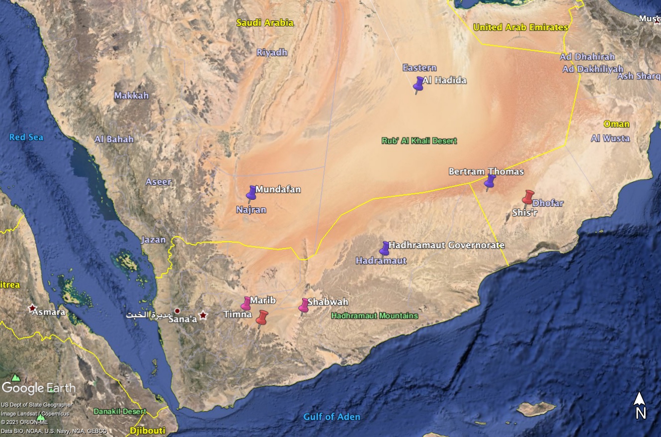
The Arabia Desert, the largest in Asia, and the fifth largest in the world, occupies most of the Arabian Peninsula. In the south, between Yemen and Oman, lies the Rub’al Khali – “The Empty Quarter” – one of the most extreme environments on earth. In the second century BCE, the Egyptian astronomer, cartographer, and philosopher Claudius Ptolemy drew the first map of this region, showing mountains, rivers, and cities. One of these cities, Mar’ib, Mariama in Ptolemy’s map, was the capital of the ancient kingdom of Saba – the legendary land of Sheba. Another city, Shabwa (Sabbatha), was the capital of the Hadhramaut. The Quran [46:21] tells us that the tribe of ‘Ad lived in the al-Ahqaf – the sand dunes in the southern part of the Arabian Peninsula. The late 19th century Muslin scholar Abdullah Yusuf Ali, defines this region as “extending from Umman at the mouth of the Persian Gulf to Hadhramaut and Yemen at the southern end of the Red Sea.” He describes its people as being tall in stature and great builders irrigating their land with canals. According to the Quran [89:6-13]
Did you not see how your Lord dealt with ‘Ad — the people of Iram—with their great stature, unmatched in any other land; and Thamûd who carved their homes into the rocks in the Stone Valley; and the Pharaoh of mighty structures? They all transgressed throughout the land, spreading much corruption there. So your Lord unleashed on them a scourge of punishment.
The punishment is described in Book 29, Verse 40:
So We seized each people for their sin: against some of them We sent a storm of stones, some were overtaken by a mighty blast, some We caused the earth to swallow, and some We drowned. Allah would not have wronged them, but it was they who wronged themselves.
According to the 12th-century Yemeni historian, Nashwān ibn Saʻīd al-Ḥimyarī, “Wabar is the name of the land which belonged to ‘Ad in the eastern parts of Yemen; to-day it is an untrodden desert owing to the drying up of its water. There are to be found in it great buildings which the wind has smothered in sand.”
Ptolemy’s map, together with these and other ancient references inspired 19th-century Western archaeological expeditions. Bertram Thomas, who crossed the Rab’al Khali in 1930, provides the first clues about the possible location of a lost city in Southern Arabia:
Suddenly the Arabs … pointed to the ground. ‘“Look, Sahib,” they cried. ‘”here is the road to Ubar. It was a great city, our fathers have told us, that existed of old; a city rich in treasure, with date gardens and a fort of red silver [gold?]. It now lies buried beneath the sands in the Ramlat Shu’ait, some few days to the north.” Other Arabs on my previous journeys had told me of Ubar, the Atlantis of the sands, but none could say where it lay. All thought of it had been banished from my mind when my companions cried their news and pointed to the well-worn tracks, about a hundred yards in cross section, graven in the plain. They bore 325°, approximately lat. 18° 45′ N., long. 52° 30’ E. on the verge of the sands.
The British explorer John Philby believed Ubar and Wabar referred to the same place. Roughly 250 miles northwest from Thomas’s location lies Al Hadida, where year later, Philby set out to find Wabar. Instead, he found five blackened meteor craters filled with sand and declared “So that was Wabar, the city of the wicked king ‘Ad destroyed by fire from heaven.”
Climate Change
How did the rich lands of Sheba, and numerous other places depicted in Ptolemy’s map exist in what is now a harsh, dry climate? Like the Sahara Desert, which once had a wetter climate, different global climate patterns could have made southern Arabia much more habitable thousands of years ago. According to Thomas:
This tradition of ancient trade routes across what is now an almost prohibitive barrier of sands should not be lightly dismissed as impossible. South Arabia is held never to have had an Ice Age, so that when the higher latitudes of the northern hemisphere lay beneath an ice cap, Arabia was enjoying a pluvial period, from which epoch date the great gorges draining the coastal mountains, and the limestone fossils washed down to the edge of the sands. This very different climate may have long persisted in modified form and made possible a very early civilisation in this region.
He goes on to say
Another interesting link in the chain of evidence has been established by zoologists from the distribution of animal life in South Arabia. The animals I collected in the Qara Mountains have proved to be mainly African or Ethiopic in affinity; they form an enclave there, for those I collected to north, east and west have been found to be exclusively Palaearctic. This enclave may well be a relic of the former animal population of the entire southern part of the peninsula when India, South Arabia and Africa had a common climate and fauna. Later, desiccation may have confined this primitive fauna to the Dhufar province, which alone in Arabia has continued to enjoy a tropical rainfall and flora, thanks to an adventitious south-west monsoon, while the denuded spaces round about have come to be re-populated by another group of animals from the north.
Were Mar’ib, Shabwa, and other places in Ptolemy’s map simply towns along ancient caravan routes as many scholars believe or were they the vestiges of an ancient prehistoric civilization whose great cities remain to be discovered beneath the sands of the Arabian Desert?
It is clear from satellite imagery that this part of the word has not always been arid. Extensive and well-developed drainage patterns seen in satellite imagery prove rivers once flowed throughout a much different landscape. In “Middle Palaeolithic and Neolithic Occupations around Mundafan Palaeolake, Saudi Arabia: Implications for Climate Change and Human Dispersals,” Crassard et al. present geochronological data supporting the existence a paleolake in the Mundafan region at the western edge of the Rub’al Khali. Lacustrine samples dated using carbon-14 and optically stimulated luminescence indicate that the paleolake first formed during the Marine Isotope Stage 5, roughly a hundred thousand years ago. The presence of freshwater mollusks suggests the lake existed over an extended period time.

Climate Zones
Climate depends on temperature and precipitation, which depend in large part on latitude. The zone of the tropics (tropics of Cancer and Capricorn), which have warm and wet climates extend 15-25° from the Equator. Dry climates tend to exist 15-35° from the Equator. In the Northern Hemisphere this zone is wider than in the Southern Hemisphere. Arabia together with northern Africa lie in a dry belt approximately 20° wide (from 15-35° N). Australia and Southern Africa lie in a thinner dry belt that is only 15° wide from (20 to 35° S). Temperate climates are on average 35-50° from the Equator, and polar climates are above 50°.

If Hapgood’s crustal displacement theory is correct, pole shifts would have caused climate zones across the globe to change in predictable ways as shown above. Considering previous estimated pole locations, if the North Pole were in the Bering Sea, Arabia would have had tropical climate 135,000 years ago. Subsequent crustal displacements that shifted the North Pole to Greenland and then to the Norwegian Sea would have returned Arabia to a dry climate between 65,000 and 135,000 years ago. During the last North American Ice Age, with the North Pole in Hudson Bay, Arabia would again have had a tropical climate roughly 15,000 to 65,000 years ago. The distribution of data collected at Mundafan is consistent with this pattern.
Timna
Considered to have been the “Indiana Jones” of his time, Wendell Phillips organized excavations at Timna and Mar’ib, two archaeological sites along the southern border of the Rub’al Khali in the 1950s (Phillips 1955). Phillips’s journey led his team west from the Hadramawt to Timna, the capital of the Qataban, which was a prominent Yemeni kingdom in the first millennium BCE. After three weeks of work at the south gate of the ancient city, excavations revealed “two massive towers constructed of rough blocks, some as large as eight by two feet.” The masonry work was good but not smoothly finished, indicating that the gate was built prior to the Qataban civilization when more polished work was done. Charred wood was found everywhere suggesting “Timna had suffered a catastrophlc destruction, in whlch fire played a major part.” Copies of a Hellenistic lion statue found in the ruins led Phillips’s archaeologist William F. Albright to date the site to around 150 BCE. However, the presence of structures that were evidently built before the Qatabans begs the question of when the city was first established.

According to Phillips, “the moon was the chief deity of all the early South Arabian kingdoms – particularly fitting in that region where the soft light of the moon brought the rest and cool winds of night as relief from the blinding sun and scorching heat of day.” Although present day aerial imagery does not allow detailed measurements of structures within the ancient city, the site appears to be oriented toward lunar standstills – the extreme directions of moonrise and moonset. But even more interesting is the alignment of the site to the Bering Sea pole shown in the above figure that implies the original site could be more than 100,000 years old.
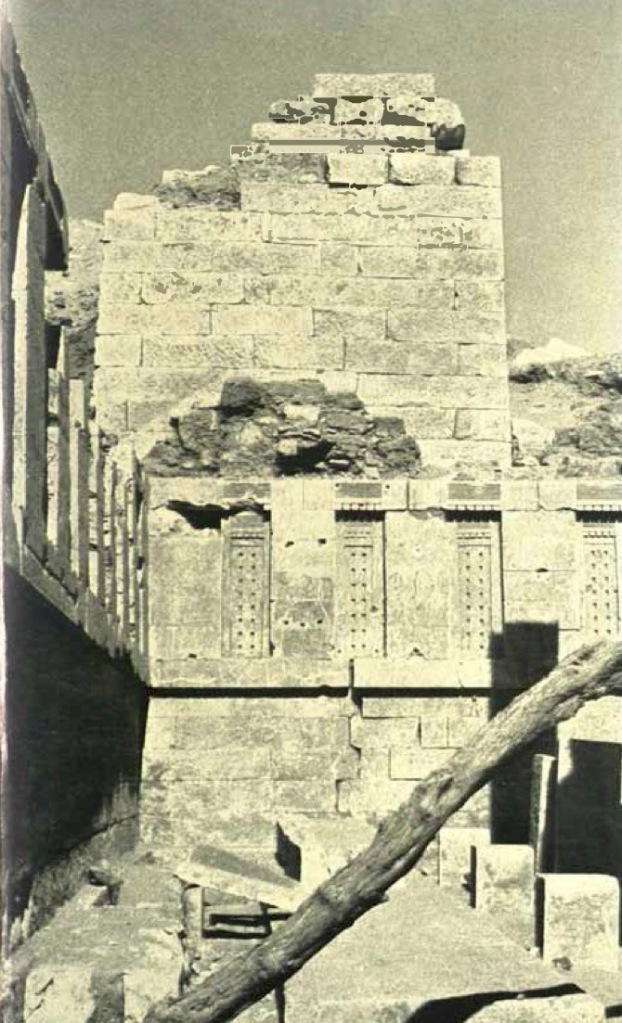

Mar’ib
Later, Phillips’ team conducted excavations at Mar’ib, the capital of the kingdom of Saba (Figure 7).
At our first inspection it seemed to us that ten Timnas might easily fit into the area of Marib. The present Arab village occupied only a small portion of the ancient city area. Columns, walls, and pillars extended everywhere as far as our eyes could see, in an endless crescent. At one point, present-day Yemenis had already dug deep for the beautifully cut Sabean stones from which they had built their ugly fortress and portions of their houses. They had gone down about seventy feet through one stratified layer after another. This depth, when compared with our cut of fifty-one feet at Hajar bin Humeid [near Timna], suggested that Marib was considerably older than the Qatabanian cities…
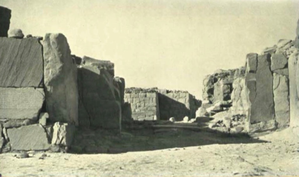
One of the team’s first discoveries was at the ancient dam:
Most amazing was the way the great stone walls had been put together. Huge boulders were so perfectly dressed that they fitted into each other like pieces in a jigsaw puzzle. We saw no trace of mortar of any kind, yet we looked at portions of the wall that were more than fifty feet high…
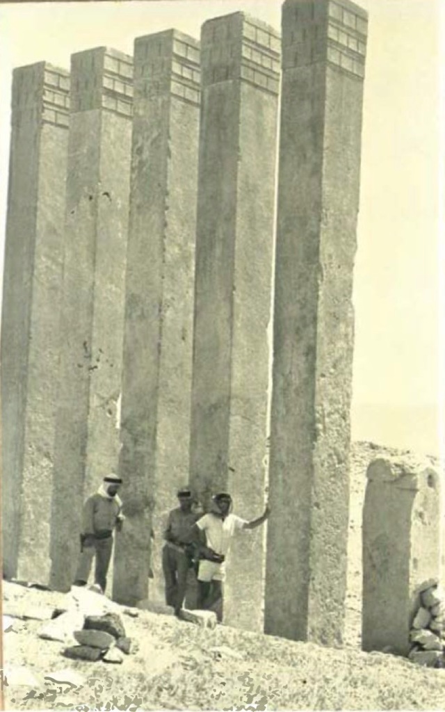
Moving on to the temple area, partially buried limestone pillars over thirty feet tall stood in the sand. At the conclusion of their work, which was cut short by growing tensions with the local population, more than thirty feet of sand had been removed, revealing “an ovoid temple about 1,000 feet in circumference, its long diameter being about 375 feet and its short diameter about 250 feet. There was an elaborate and complicated peristyle hall and complex of buildings terminating in a row of eight tall columns.” The wall of the temple “was about thirteen and a half feet thick, constructed of perfectly fitted ashlar masonry, with a sand and rubble fill. In places, the wall was preserved to a height of more than twenty-seven feet above the floor of the entrance hall. Unfortunately, there was no way of knowing how high it had originally been or how the top was finished. Portions of the wall displayed variations in workmanship, indicating the different contractors or technicians involved and suggesting that the wall had been built over a long period of time…” Inscriptions revealed the “temple itself was called Awwam, and the god Ilumquh to whom it was dedicated was the Sabatean version of the moon god common to all South Arabian religions.”

A large mound-like structure that is part of the ancient city to the northwest of the Awwam Temple appears to be aligned in the direction of minor lunar standstills. It also appears to be cardinally aligned relative to the Hudson Bay pole. The Temple of Awwam itself is not currently aligned to the sun or moon. However, if the North Pole were in Hudson Bay, the Awwam Temple would be oriented in directions consistent with solstices and lunar standstills relative to the former pole as shown in the figure below. That the alignments of the ancient city and the Awwam Temple both reference the Hudson Bay pole suggest Mar’ib could be 15,000 to 65,000 years old.

Shabwa
Although Phillips flew over Shabwa they were unable to excavate there. However, like Mar’ib, certain structures at Shabwa appear to be aligned to the moon relative to the direction of the Hudson Bay pole as shown below.

Shis’r
One has to wonder if the Temple of Awwam could have been the “Iram of the Pillars” mentioned in this alternative translation the Quran [89:6-8]
Have you not considered how your Lord dealt with ʿAad With Iram – who had lofty pillars, The likes of whom had never been created in the land?
It is generally assumed that Iram was Ubar, or Wabar, the lost city sought by Thomas, Philby, and more recently by a team guided by Ranulph Fiennes in the 1990s. Fiennes’s life-long search for Ubar lead to the 1991 excavations at Shis’r that are thought by some to be the ruins of the ancient city of Ubar. Media hype at the time stated that satellite imagery helped the team locate the site. Although the images do show ancient as well as more recent tracks that seem to converge at Shis’r, they provided no direct indication of anything beneath the sands. However, subtle features in an L-band SIR-C radar image (which can penetrate several feet of dry sand) over the area suggests a possible buried linear structure over five miles in length. The impression of a linear structure could be the result of a chance alignment of natural features, or be evidence of an artificial construction, perhaps a wall.
What is particularly interesting is that the long dimension of this feature is aligned in the direction of the Bering Sea pole.

Discussion
Given the historical importance of the moon in South Arabian kingdoms it seems no coincidence that structures at Timna and Mar’ib appear to be aligned to the moon. That structures at Shabwa and Mar’ib also appear to reference the moon but at an earlier time, that is, relative to the Hudson Bay pole suggest the moon was also important to earlier people who lived in this part of the world before the last Ice Age.
It is hard to conceive of how Sheba and other ancient kingdoms not only survived but once prospered in and around the Rub’al Khali unless the climate was much different than it is today. That Hapgood’s theory can account both for climate change in this and other parts of the world and for the alignment of ancient structures such as those discussed in this and previous articles whose orientation is otherwise hard to explain may also be no coincidence.
References
Bertram Thomas (1932) Arabia Felix: Across the Empty Quarter of Arabia.
Wendell Phillips (1955) Qataban and Sheba: Exploring Ancient Kingdoms on the Biblical Spice Routes of Arabia.
Abdullah Yusuf Ali (1934) The Holy Qur’an: Text, Translation and Commentary. See https://en.wikipedia.org/wiki/The_Holy_Qur%27an:_Text,_Translation_and_Commentary
H. Stewart Edgell (2003) “The myth of the “lost city of the Arabian Sands,” Proceedings of the Seminar for Arabian Studies, Vol. 34, London, 17-19 July 2003, pp. 105-120.
See https://www.jstor.org/stable/41223810
William C. Brice (1973) “The Construction of Ptolemy’s Map of South Arabia,” Proceedings of the Seminar for Arabian Studies, Vol. 4, Cambridge, June, 1973, pp. 5-9.
See https://www.jstor.org/stable/41223130
Re ́my Crassard, Michael D. Petraglia, Nick A. Drake, Paul Breeze, Bernard Gratuze, Abdullah Alsharekh, Mounir Arbach, Huw S. Groucutt, Lamya Khalidi, Nils Michelsen, Christian J. Robin, and Je ́re ́mie Schiettecatte (2013) “Middle Palaeolithic and Neolithic Occupations around Mundafan Palaeolake, Saudi Arabia: Implications for Climate Change and Human Dispersals.” PLoS ONE 8(7): e69665. doi:10.1371/journal.pone.0069665.
Ranulph Fiennes (1992) Atlantis of the Sands: The Search for the Lost City of Ubar, Bloomsbury.
Featured image at the top of the article courtesy Javierblas/Creative Commons.


Hi Mark, how are you?
I have to much interesting in Atlantis, some memories from the past too.
I like to study and collaborate more with this theme.
Kind Regards,
Felipe Lobo
Em qua., 7 de jul. de 2021 às 11:48, Before Atlantis escreveu:
> Mark Carlotto posted: ” Could climate changes caused by pole shifts > explain the rise and fall of ancient civilizations in certain parts of the > world? We explore this possibility in Southern Arabia, where evidence > supports the existence of a previous civilization tens of thousan” >
LikeLike
I wanted to thank you for this great read!! I certainly enjoyed every bit of it. I have got you book marked to look at new stuff you post…
LikeLiked by 1 person
Cities from 100,000 years ago…amazing.
LikeLike
Excellent article! Congratulations on the information. 35203707
LikeLike